
Laufenburg, Aargau facts for kids
Quick facts for kids
Laufenburg
|
||
|---|---|---|

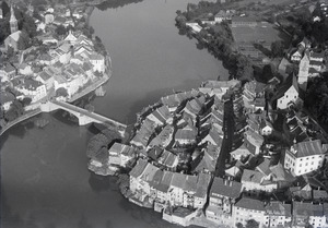
The old town viewed from the German side
|
||
|
||

Laufenburg
Location in Switzerland

Laufenburg
Location in Canton of Aargau
|
||
| Country | Switzerland | |
| Canton | Aargau | |
| District | Laufenburg | |
| Area | ||
| • Total | 14.47 km2 (5.59 sq mi) | |
| Elevation | 315 m (1,033 ft) | |
| Population
(Dec 2020 )
|
||
| • Total | 3,659 | |
| • Density | 252.87/km2 (654.93/sq mi) | |
| Postal code |
5080
|
|
| Surrounded by | Kaisten, Laufenburg (DE-BW), Sulz | |

Laufenburg is a town in Switzerland. It is located in the Aargau canton. Laufenburg is also the main town of its district.
In 2010, the nearby town of Sulz joined with Laufenburg. About 2,000 people live here. Across the Rhine River is another town called Laufenburg in Germany. These two towns used to be one city. But in the early 1800s, Napoleon divided them. Now, two bridges connect the two Laufenburgs.
In 1985, Laufenburg won the Wakker Prize. This award is for towns that do a great job of keeping their old buildings and history safe.
Contents
Discovering Laufenburg's Past

Laufenburg is built on a high spot along the Rhine River. This spot was chosen because it was good for building a bridge. There was a section of fast-moving water, like small waterfalls, nearby.
The town was first mentioned in records in 1207. At that time, a powerful family called the Habsburgs took control of the castles on both sides of the Rhine. Rudolf II of Habsburg helped the area grow into a city. He is known as the founder of Laufenburg.
Later, the Habsburg family split into different branches. One branch was called Habsburg-Laufenburg. In 1386, the last ruler from this branch sold control of Laufenburg to another Habsburg leader. This made Laufenburg part of the Habsburg lands in what is now Austria. It was one of four important "Forest Cities" along the Rhine.
During the Thirty Years War, Laufenburg was occupied for 13 years. In 1792, the French Revolutionary Army used it as a base. In 1801, the Rhine River became the border between parts of the region. This divided Laufenburg into two towns: one in Switzerland and one in Germany. It took many years to sort out how to share the town's buildings and land. Most of the city hall and market were on the Swiss side. Most of the land and forests were on the German side.
Exploring Laufenburg's Landscape

Laufenburg covers an area of about 2.28 square kilometers (0.88 square miles). A good part of this land is covered by forests. Another part is used for farming. Many buildings and roads make up the settled areas. The Rhine River also flows through the municipality.
Laufenburg is the main town of its district. It includes the part of the town on the left bank of the Rhine, which is the Swiss side. The German part of Laufenburg is across the river.
Understanding the Coat of Arms
The coat of arms for Laufenburg shows a red lion standing on a gold background. This design is called Or a Lion rampant Gules in heraldry.
People and Population
Laufenburg has a population of about 2,000 people. Many different nationalities live here. Most people in Laufenburg speak German. Italian is the second most common language, followed by Albanian.
The town has a mix of ages. About 10% of the population are children under 9 years old. Another 11% are teenagers between 10 and 19. The rest are adults of various ages.
Most people in Switzerland are well-educated. In Laufenburg, many adults have finished high school or gone on to higher education. The town has schools for primary, secondary, and university-level students.
Important Landmarks and History
Laufenburg has several important historical sites. These are recognized as national heritage sites in Switzerland. They include:
- The old court house.
- The Catholic parish church.
- The Laufenburg power plant and the village around it.
- The ruins of Laufenburg Castle.
- The remains of an old Roman fort near the Rhine.
The entire old town of Laufenburg is also considered an important heritage site.
-
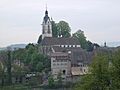
Laufenburg parish church
-
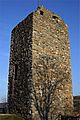
Ruins of the tower of Laufenburg castle


How People Work in Laufenburg
Laufenburg has different types of jobs. Some people work in farming. Many others work in factories or making things. A large number of people work in the service sector. This includes jobs like shops, offices, and healthcare.
Many people who live in Laufenburg travel to other towns for work. Also, many people from outside Laufenburg come into the town to work. Most workers use public transport or private cars to get to their jobs.
Religion in Laufenburg

Based on a census from 2000, most people in Laufenburg are Roman Catholic. A smaller number belong to the Swiss Reformed Church. There are also a few people who follow the Christian Catholic faith.
Getting Around: Transport
Laufenburg is at the end of a railway line that connects to other towns. The Laufenburg railway station serves local trains. This makes it easy for people to travel to and from the town.
Notable People from Laufenburg
- Count Johann I. von Habsburg-Laufenburg-Rapperswil (1295/97 – 1337) – A count from the Habsburg-Laufenburg family.
- Hans Müller von Bulgenbach (1490 – 1525) – A leader of peasants during a war in Germany.
- Christoph Rehmann-Sutter (born 1959) – A Swiss expert in bioethics, which studies ethical issues in biology and medicine.
See also
 In Spanish: Laufenburg (Argovia) para niños
