
Lautém Municipality facts for kids
Quick facts for kids
Lautém
|
||
|---|---|---|
|
||
_with_Jaco_Island_to_left.jpg)
Valu Beach, Tutuala
|
||
|
||

|
||
|
OpenStreetMap
|
||
| Country | ||
| Capital | Lospalos | |
| Administrative posts |
|
|
| Area | ||
| • Total | 1,816.7 km2 (701.4 sq mi) | |
| Area rank | 3rd | |
| Population
(2015 census)
|
||
| • Total | 65,240 | |
| • Rank | 7th | |
| • Density | 35.911/km2 (93.010/sq mi) | |
| • Density rank | 12th | |
| Households (2015 census) | ||
| • Total | 12,050 | |
| • Rank | 7th | |
| Time zone | UTC+09:00 (TLT) | |
| ISO 3166 code | TL-LA | |
| HDI (2017) | 0.607 medium · 7th |
|

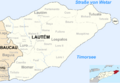
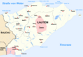
Lautém is a special part of East Timor, located at the very eastern end of the country. It is one of the 12 municipalities (like a large region or district) in East Timor.
Lautém is home to about 65,240 people (as of 2015). It covers an area of around 1,816.7 square kilometers. The main city and capital of Lautém is Lospalos. Lospalos is about 248 kilometers east of Dili, which is the capital city of East Timor.
Contents
What Does "Lautém" Mean?
The name Lautém comes from the local Fataluku language. It's a Portuguese version of the Fataluku word Lauteinu.
This word Lauteinu is a mix of two Fataluku words: lau which means 'cloth', and tein which means 'sacred'. So, Lautém means 'sacred cloth'. Long ago, the people who lived here were known as Lauteinu or Lauteira.
Exploring Lautém's Geography
Lautém is surrounded by beautiful natural features. To the west, it shares borders with the Baucau and Viqueque municipalities.
To the north, you'll find the Banda Sea. To the south, there's the Timor Sea. Lautém also includes the easternmost tip of the island, called Cape Cutcha, which is in the Tutuala area. You can also find the small, lovely Jaco Island here.
The borders of Lautém municipality are the same as they were when East Timor was known as Portuguese Timor. Back then, some places had Portuguese names. For example, the city of Lautém was once called Vila Nova de Malaca.
Natural Beauty and Wildlife
Lautém is famous for its stunning sandy beaches. It also has wild, mountainous areas and rugged, untouched landscapes. It's a great place for nature lovers.
Many unique birds that live only in East Timor can be found here. Near the city of Lautém, there are ancient cave drawings to explore. You can also see many old stone sarcophagi (stone coffins) and special shrines throughout the area.
Lautém is especially known for its amazing birdwatching opportunities. The municipal flag even features the head of a yellow-crested cockatoo, a famous bird from the region.
Administrative Areas of Lautém
The municipality of Lautém is divided into smaller areas called administrative posts. These used to be known as sub-districts.
The administrative posts in Lautém are:
- Iliomar
- Lautém
- Lospalos
- Luro
- Tutuala
People and Languages
In Lautém, people speak a variety of languages. The official languages of East Timor are Portuguese and Tetum.
However, in Lautém, about 30,000 people also speak a language called Fataluku. This is a Papuan language, and many Fataluku speakers live in the eastern part of the municipality. Some of them might not speak any other language.
Images for kids
-
Administrative posts and sucos of Lautém
-
Cities and rivers in Lautém


See also
 In Spanish: Distrito de Lautem para niños
