Lehigh, Iowa facts for kids
Quick facts for kids
Lehigh, Iowa
|
|
|---|---|
|
City
|
|
 |
|

Location of Lehigh, Iowa
|
|
| Country | United States |
| State | |
| County | Webster |
| Area | |
| • Total | 2.17 sq mi (5.63 km2) |
| • Land | 2.11 sq mi (5.47 km2) |
| • Water | 0.06 sq mi (0.16 km2) |
| Elevation | 965 ft (294 m) |
| Population
(2020)
|
|
| • Total | 395 |
| • Density | 187.12/sq mi (72.25/km2) |
| Time zone | UTC-6 (Central (CST)) |
| • Summer (DST) | UTC-5 (CDT) |
| ZIP code |
50557
|
| Area code(s) | 515 |
| FIPS code | 19-44265 |
| GNIS feature ID | 0458277 |
Lehigh is a small city located in Webster County, Iowa, in the United States. In 2020, about 395 people lived there.
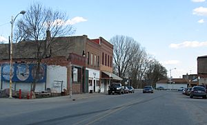
What makes Lehigh special is that the Des Moines River flows right through it, dividing the town into two parts. Long ago, these two parts were actually separate towns! The west side was always called Lehigh. But the east side had a fun name: Slabtown. You can still see a sign that says "Slabtown Traders" near a playground, which might remind people of a summer flea market held there.
For many years, Lehigh was surrounded by coal mines. It also had a large factory that made clay sewer pipes until the 1980s. Today, you can visit beautiful natural spots nearby, like Dolliver State Park, Brushy Creek State Recreation Area, and Woodman Hollow State Preserve.
Contents
A Look Back: Lehigh's History
How Lehigh Began
The first people to settle in the area that became Lehigh were Mr. Reed and Mr. Wright in 1855. They built a steam-powered sawmill there. At first, the town was called Slabtown. This was because they used "slabs"—leftover pieces of wood from the mill—to build things.
By 1870, the town had a Methodist church and a school. A man named Oliver Tyson bought the sawmill and made it bigger, adding a flour mill. He also opened a store. Later, the town's name was changed to Lehigh. This new name was chosen because the local coal mines reminded people of the coal-rich Lehigh Valley in Pennsylvania.
Coal Mining and Railroads
In 1871, a man named W. C. Wilson started a coal mine in Lehigh. He created the Crooked Creek Railroad and Coal Company. This company built a special narrow gauge railway line. It ran from Judd, a town 8.5 miles south, all the way to the mines. The railway even had a long wooden bridge over the Des Moines River. Later, the line was extended to Webster City. By 1894, the company had opened five mines.
Mining was very important to Lehigh. In 1878, the town shipped over 5,600 tons of coal! The amount of coal shipped grew each year. Many people in Lehigh worked in the mines.
The Crooked Creek railroad was made wider in 1880. In 1916, it became part of the Fort Dodge, Des Moines and Southern Railroad. This was Iowa's longest Interurban line, which means it carried both people and goods. The trains switched from electric power to diesel in the 1950s. The railway line was finally closed in 1962.
Other Industries: Bricks and Tiles
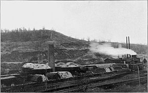
Besides coal mining, Lehigh was also known for making bricks and drainage tiles. These factories used the shale (a type of rock) found near the coal seams. This shale was a good source of clay. They used local coal to heat their kilns (large ovens) to bake the clay products.
One of these companies, the Lehigh Brick and Tile company, even won a contract to provide paving bricks for the city of Dubuque, Iowa in 1896. However, they had a big fire in 1897. By 1901, there were two large brick factories in Lehigh: the Corey Pressed Brick Company and the Lehigh Clay Works. The old Lehigh Brick and Tile works was also being rebuilt. These factories made both bricks for buildings and drainage tiles used in farming.
Lehigh's Location: Geography
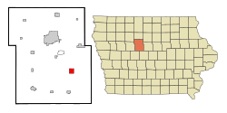
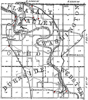
Lehigh is located at 42°21′26″N 94°3′5″W / 42.35722°N 94.05139°W. It sits on the west bank of the Des Moines River.
The United States Census Bureau says that the city covers about 2.15 square miles (5.57 square kilometers) in total. Most of this area, about 2.09 square miles (5.41 square kilometers), is land. The rest, about 0.06 square miles (0.16 square kilometers), is water.
People of Lehigh: Demographics
| Historical populations | ||
|---|---|---|
| Year | Pop. | ±% |
| 1890 | 870 | — |
| 1900 | 806 | −7.4% |
| 1910 | 928 | +15.1% |
| 1920 | 1,090 | +17.5% |
| 1930 | 996 | −8.6% |
| 1940 | 1,004 | +0.8% |
| 1950 | 881 | −12.3% |
| 1960 | 846 | −4.0% |
| 1970 | 739 | −12.6% |
| 1980 | 654 | −11.5% |
| 1990 | 536 | −18.0% |
| 2000 | 497 | −7.3% |
| 2010 | 416 | −16.3% |
| 2020 | 395 | −5.0% |
| Iowa Data Center Source: |
||
Population in 2020
In 2020, the census counted 395 people living in Lehigh. There were 188 households and 113 families. The city had about 187 people per square mile (72.2 per square kilometer).
Most residents (97.2%) were White. About 2.8% of people were from two or more races. A small number (1.0%) were Hispanic or Latino.
The average age in Lehigh was 43.9 years. About 22.0% of residents were under 20 years old. About 22.0% were 65 years or older. The city had slightly more males (56.2%) than females (43.8%).
Learning in Lehigh: Education
Lehigh is part of the Southeast Valley Community School District. Students in Lehigh attend Southeast Valley High School in Gowrie.
Before 2023, Lehigh was part of the Southeast Webster-Grand Community School District. This district was formed in 2005 when two smaller districts joined together. In 2023, the Southeast Webster-Grand district merged into the Southeast Valley district.
Famous People from Lehigh
- Hugh Lester was a professional soccer player who played for Liverpool F.C..
- John Donaldson (pitcher) was a professional baseball player who finished his long career in Lehigh in 1949.
See also
 In Spanish: Lehigh (Iowa) para niños
 | George Robert Carruthers |
 | Patricia Bath |
 | Jan Ernst Matzeliger |
 | Alexander Miles |


