Leisure City, Florida facts for kids
Quick facts for kids
Leisure City, Florida
|
|
|---|---|

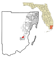
Location in Miami-Dade County and the state of Florida
|
|

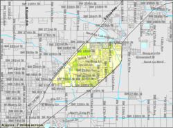
U.S. Census Bureau map showing CDP boundaries
|
|
| Country | |
| State | |
| County | |
| Area | |
| • Total | 3.33 sq mi (8.62 km2) |
| • Land | 3.26 sq mi (8.45 km2) |
| • Water | 0.07 sq mi (0.17 km2) |
| Elevation | 7 ft (2 m) |
| Population
(2020)
|
|
| • Total | 26,324 |
| • Density | 8,069.90/sq mi (3,115.59/km2) |
| Time zone | UTC-5 (Eastern (EST)) |
| • Summer (DST) | UTC-4 (EDT) |
| ZIP code |
33033 (Homestead)
|
| Area code(s) | 305, 786, 645 |
| FIPS code | 12-39950 |
| GNIS feature ID | 0285449 |
Leisure City is a community in Miami-Dade County, Florida, United States. It is a "census-designated place" (CDP), which means it's an area defined by the government for counting people, but it's not an officially incorporated city. Leisure City includes a smaller, older area called Modello in its northwestern part.
One of the most famous places here is the Coral Castle Museum, which is located in the Modello area. Leisure City is part of the larger Miami metropolitan area in South Florida. In 2020, about 26,324 people lived there, which was more than the 22,655 people counted in 2010.
Geography and Location
Leisure City is located about 27 miles (43 km) southwest of Miami. It shares borders with the city of Homestead to the south and east. To the north, you'll find the community of Naranja, and to the northwest is Redland.
Two important roads pass near Leisure City. U.S. Route 1 runs along the northwest side. This road goes south into Homestead and northeast towards Miami. The Homestead Extension of Florida's Turnpike is a highway that runs along the border with Homestead. You can get onto this highway from exits near Leisure City.
The community covers a total area of about 3.33 square miles (8.62 square kilometers). Most of this area, about 3.26 square miles (8.45 square kilometers), is land. The rest, about 0.07 square miles (0.17 square kilometers), is water.
Climate
Leisure City has a "Tropical Savanna Climate," also known as "Aw" in the Köppen Climate Classification system. This means it generally has warm temperatures all year round and distinct wet and dry seasons.
| Climate data for Leisure City, Florida | |||||||||||||
|---|---|---|---|---|---|---|---|---|---|---|---|---|---|
| Month | Jan | Feb | Mar | Apr | May | Jun | Jul | Aug | Sep | Oct | Nov | Dec | Year |
| Mean daily maximum °C (°F) | 25 (77) |
26 (78) |
27 (81) |
29 (84) |
31 (87) |
32 (89) |
32 (90) |
33 (91) |
32 (89) |
30 (86) |
27 (81) |
26 (78) |
29 (84) |
| Mean daily minimum °C (°F) | 12 (54) |
12 (54) |
14 (58) |
16 (61) |
19 (66) |
21 (70) |
22 (71) |
22 (71) |
22 (71) |
19 (67) |
16 (61) |
13 (56) |
17 (63) |
| Average precipitation mm (inches) | 43 (1.7) |
48 (1.9) |
56 (2.2) |
84 (3.3) |
160 (6.4) |
230 (9.2) |
200 (7.8) |
210 (8.2) |
250 (9.7) |
200 (7.7) |
66 (2.6) |
33 (1.3) |
1,600 (62) |
| Source: Weatherbase | |||||||||||||
Population Facts
The number of people living in Leisure City has grown over the years.
| Historical population | |||
|---|---|---|---|
| Census | Pop. | %± | |
| 1960 | 3,001 | — | |
| 1980 | 17,905 | — | |
| 1990 | 19,379 | 8.2% | |
| 2000 | 22,152 | 14.3% | |
| 2010 | 22,655 | 2.3% | |
| 2020 | 26,324 | 16.2% | |
| source: | |||
In 2020, there were 26,324 people living in Leisure City. These people lived in about 7,028 homes, and 6,006 of these were families. This shows a steady increase in population compared to earlier years.
Schools in Leisure City
Students in Leisure City attend schools that are part of the Miami-Dade County Public Schools system. There are three main schools that serve the area:
- Leisure City K-8 (for younger students)
- Homestead High School
- South Dade High School
See also
 In Spanish: Leisure City para niños
 | William L. Dawson |
 | W. E. B. Du Bois |
 | Harry Belafonte |

