
Letocetum facts for kids

View of Letocetum from St. John the Baptist Church
|
|
| Location | Wall, Staffordshire |
|---|---|
| Region | |
| Type | mansio and bath house |
| History | |
| Founded | c. 50 CE |
| Abandoned | 4th century |
| Periods | Roman Empire |
| Cultures | Romano-British |
| Site notes | |
| Condition | Ruins |
| Ownership | National Trust |
| Public access | Yes |
Letocetum was an important Roman settlement in ancient Britain. It was a busy place where Roman soldiers and travelers could stop and rest. The site was located near where two major Roman roads, Watling Street and Icknield Street, met. Today, you can find the remains of Letocetum in the village of Wall, England.
The National Trust owns and manages the site, calling it the Letocetum Roman Baths Site & Museum. English Heritage also helps look after it as the Wall Roman Site.
The Romans first arrived at Letocetum around 50 AD. They built a fortress during their early invasion of Britain. The area couldn't support many soldiers for long. So, Letocetum became a large "posting station" where official travelers could stay. Over time, the settlement grew with bath houses and inns, called mansiones, for both travelers and local people.
Archaeologists learned a lot about Letocetum from digs in 1912–13. These digs focused on the mansio and bath-house areas. The ruins you see today are from a stone bath house and mansio built around 130 AD. By then, Letocetum was no longer a military base but a civilian town.
The town was busiest in the 2nd and 3rd centuries, covering a large area. Towards the end of the 3rd century, the town moved inside strong defensive walls. After the Romans left Britain in the early 5th century, Letocetum slowly faded away. The modern village of Wall now stands where this ancient Roman town once thrived.
Contents
What's in a Name?
The Romans called this place Etocetum. This name likely came from an older British Celtic name, *Lētocaiton. It probably meant "Grey-wood," perhaps because of the ash and elm trees in the area. Some historians think Letocetum might be the "Fort Greywood" mentioned in an old book called History of the Britains.
Letocetum's Story
Early Settlements
Before the Romans came, a small native village probably existed here. It might have been a trading spot between two British tribes: the Corieltauvi from the East and the Cornovii from the West. These tribes didn't fight much against the Romans.
A Roman Military Stop
Around 50 AD, a Roman army unit built a large wooden fort on a hilltop at Letocetum. This fort housed soldiers during battles against other British tribes. It was a good place for defense, but the land wasn't good for farming. So, most soldiers moved to a bigger fort nearby around 58 AD. Letocetum then became a key stopping point for travelers.
A Busy Posting Station

The Romans built a mansio (an inn) for official messengers and travelers using Watling Street. A bath house was also built for these travelers and the growing local population. Workers were needed to supply wood for the baths, care for animals, and fix vehicles. Local people likely provided these services.
The town grew, covering about 20 to 30 acres. Roman graves from the 1st and 2nd centuries have been found along Watling Street. A round dip in the ground might have been a Roman amphitheatre or a training area for horses. A large pot shaped like the goddess Minerva was found near the modern church. This suggests there might have been a temple to Minerva there.
When the Romans first arrived, they used existing paths. But they soon needed better roads. Watling Street was paved with stone around 70 AD. Another important road, Ryknild Street, also connected Letocetum to other major Roman towns. Watling Street was about 7.3 meters (24 feet) wide where it crossed Ryknild Street.
First Inns and Bath Houses
Archaeologists found the foundations of the last mansio and bath house in 1912–13. Below these, they found traces of two earlier wooden mansiones.
The first mansio was built around 54–60 AD. It was made of wood and mud, with plastered and painted walls. It likely had a thatched roof and was destroyed by fire. This happened sometime in the early 2nd century.
The second mansio was also a wooden building with painted walls. It had a large well in its courtyard. This mansio was taken apart around 140–150 AD to make way for a new one. Around this time, the military left Letocetum completely.
The earliest bath house was found in 1956. A coin from 71 AD found there suggests it was built around 100 AD. This bath house was very well built, showing it was likely used by the military.
A Civilian Town: New Inn and Bath House

After 130 AD, the Roman army no longer used Letocetum. The town then became part of the Cornovii tribe's territory. Around this time, a new stone mansio and bath house were built.

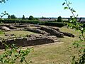
The third mansio was built around 130 AD and was at least two stories high. It had a grand entrance with columns and a tiled roof. Inside, there was a courtyard, possibly with a garden. Some rooms had washing facilities, and the largest room was heated by an underfloor heating system called a hypocaust.
.jpg)
Next to the mansio was the public bath house, separated by a cobbled road. It had a large covered courtyard, possibly a basilica (a public hall). At one end was the "stoke-room" where wood fires heated the water. Hot air from these fires circulated under the floors of the warm rooms, like the tepidarium (warm room) and caldarium (hot room). This kept the floors and walls warm for bathers.
Later Roman Defenses

Towards the end of the 3rd century, Letocetum's public buildings, like the bath house and mansio, were destroyed by fire. Around this time, strong defensive walls were built. These new walls did not include the old bath house or mansio sites. The reason for this change might have been economic.
The new defenses were built around 300 AD, right across Watling Street. They included a stone wall about 2.7 meters (9 feet) thick, with three ditches in front and a turf bank behind. The area inside these walls was about 2.1 hectares (5 acres).
These defenses were likely built because of uprisings by Welsh tribes. To protect against future attacks, a series of strongholds, including Letocetum, were built along Watling Street. All Roman finds from the 4th century come from inside these walls. This suggests everyone lived within the defenses by then. The latest Roman coin found at Letocetum was from 381 AD. Roman rule ended in Britain in the early 5th century, and nothing from after this time has been found at the site.
After the Romans Left
Letocetum remained important for a while, even being listed as a significant city in a 9th-century book. However, we don't know much about what happened right after the Romans left.
Letocetum lost its importance when the nearby town of Lichfield grew in the 7th century. When the area became known again, it had a new name: Wall. This name came from the remains of the old Roman defensive walls, which were still standing in the early 1800s.
Images for kids
-
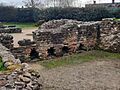
The hypocaust in the tepidarium at the 3rd Bath House, where the pilae stacks would have been
-
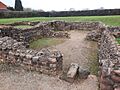
The tepidarium and caldarium at the 3rd Bath House
-
The apodyterium at the 3rd Bath House
-
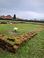
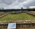
The exercise hall at the 3rd Bath House
-
The heated rooms and apodyterium of the 3rd Bath House from the exercise hall, also from the 3rd Bath House
-
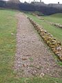
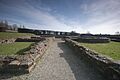
Preserved portion of the street which ran between the 3rd Mansio and the 3rd Bath House; here, the street has been preserved on the side next to the 3rd Bath House
-
Entire length of the street which passed between the 3rd Mansio and the 3rd Bath House
-
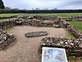
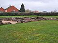
The 3rd Mansio as seen from across the street
-
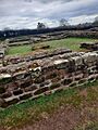
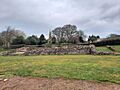
Ruins of the 3rd Mansio
-
Ruins of the 3rd Mansio
-
The atrium of the 3rd Mansio
-
Probable site of the kitchens used to serve the 3rd Mansio
-
Letocetum in 2006
-

Watling Street in Wall, which used to run through Letocetum; the ruins of Letocetum are directly to the east of this stretch of Watling Street


Jul2006.jpg)

See also
 In Spanish: Letocetum para niños
