Liberty, Tennessee facts for kids
Quick facts for kids
Liberty, Tennessee
|
|
|---|---|

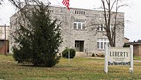
Liberty's Town Hall
|
|

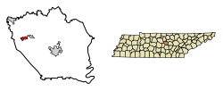
Location of Liberty in DeKalb County, Tennessee.
|
|
| Country | United States |
| State | Tennessee |
| County | DeKalb |
| Settled | 1790s |
| Incorporated | 1850 |
| Area | |
| • Total | 1.16 sq mi (2.99 km2) |
| • Land | 1.16 sq mi (2.99 km2) |
| • Water | 0.00 sq mi (0.00 km2) |
| Elevation | 610 ft (186 m) |
| Population
(2020)
|
|
| • Total | 334 |
| • Density | 289.18/sq mi (111.69/km2) |
| Time zone | UTC-6 (Central (CST)) |
| • Summer (DST) | UTC-5 (CDT) |
| ZIP code |
37095
|
| Area code(s) | 615 |
| FIPS code | 47-42040 |
| GNIS feature ID | 1313986 |
Liberty is a small town located in DeKalb County, Tennessee, in the United States. In 2020, about 334 people lived there. Liberty's main street is quite special. It was added to the National Register of Historic Places in 1987. This means it's an important historical area.
Contents
History of Liberty, Tennessee
Early Settlement and Growth
Liberty was first settled around 1797. An American Revolutionary War veteran named Adam Dale started the community. He came from Maryland and built a mill on Smith Fork Creek. This mill helped the town grow.
Historic Buildings and Places
Many buildings on Main Street in Liberty are part of an historic district. This district is listed on the National Register of Historic Places. One important building is the Liberty High School. It was built using limestone found in the area. The Salem Baptist Church and its cemetery are also part of this historic area.
Tornado of 1889
On March 23, 1889, a strong tornado hit Liberty. It knocked down many trees and badly damaged homes. A local church was completely destroyed. Luckily, no one was reported to have died in the storm.
Geography of Liberty
Liberty is located in the central part of Tennessee. Its exact location is 36.004959 degrees north and 85.972816 degrees west. The town covers about 1.0 square mile (2.99 square kilometers) of land. There is no water area within the town limits.
People Living in Liberty
| Historical population | |||
|---|---|---|---|
| Census | Pop. | %± | |
| 1880 | 285 | — | |
| 1950 | 314 | — | |
| 1960 | 293 | −6.7% | |
| 1970 | 332 | 13.3% | |
| 1980 | 365 | 9.9% | |
| 1990 | 391 | 7.1% | |
| 2000 | 367 | −6.1% | |
| 2010 | 310 | −15.5% | |
| 2020 | 334 | 7.7% | |
| Sources: | |||
In 2000, there were 367 people living in Liberty. These people made up 160 households and 112 families. The town's population density was about 354.5 people per square mile.
About 31.9% of households had children under 18. Most households (53.1%) were married couples living together. The average household had 2.29 people. The average family had 2.70 people.
The population was spread out by age. About 22.1% were under 18 years old. About 10.4% were 65 years or older. The average age in Liberty was 40 years old.
The Allen Bluff Mule
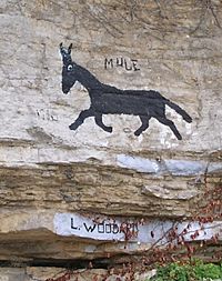
The "Allen Bluff Mule" is a famous painting on a limestone cliff. It's located on U.S. Route 70 in Liberty. People in Liberty have different stories about who painted it. Some say a local man named Lavader Woodard did it. Others think it was an advertisement for a local farm.
Dr. Wayne T. Robinson said he painted the original mule. He claimed he did it in October 1906. He was a 21-year-old college student at the time. He was inspired by a comic strip character named Maud the Mule. This character was from a comic strip called And Her Name Was Maud.
In 2003, residents worried that a road expansion might harm the painting. They wrote letters to the Tennessee Department of Transportation. They also put up "Save the Mule" signs. Luckily, the road expansion was far enough away. The mule painting was never in danger.
Famous People from Liberty
- Bob Griffith – A baseball player.
- Justin Potter (also known as "Jet" Potter) (1898–1961) – A notable person from the area.
See also
 In Spanish: Liberty (Tennessee) para niños
 | John T. Biggers |
 | Thomas Blackshear |
 | Mark Bradford |
 | Beverly Buchanan |


