
Lichfield Canal facts for kids
Quick facts for kids Lichfield Canal |
|
|---|---|

A short section at the eastern end acts as moorings
|
|
| Specifications | |
| Locks | 30 |
| Status | active restoration project |
| History | |
| Original owner | Wyrley and Essington Canal Company |
| Date of act | 1794 |
| Date completed | 1797 |
| Date closed | 1955 |
| Geography | |
| Start point | Huddleford Jn, Coventry Canal |
| End point | Ogley Junction, Brownhills |
The Lichfield Canal is a historic waterway in England. It was once part of the Wyrley and Essington Canal. This section stretched about 7 miles (11.3 km). It ran from Ogley Junction in Brownhills to Huddlesford Junction, near Lichfield.
The canal was closed in 1955, along with other parts of the Wyrley and Essington Canal. Much of it was filled in over the years. However, people started talking about restoring it in 1975. Since 1990, the Lichfield and Hatherton Canals Restoration Trust has been working hard. They are digging out and rebuilding parts of the canal. A big project was building an aqueduct over the M6 Toll motorway. This aqueduct is ready for when the canal reaches it.
Contents
History of the Lichfield Canal
How the Canal Was Built
The Wyrley and Essington Canal was approved by a special law on April 30, 1792. This law allowed a canal to be built from Horseley Junction near Wolverhampton to Sneyd Junction near Bloxwich. The main part of the canal was designed to be flat. It followed a specific height of 473 feet (144 meters) above sea level.
From this main canal, two branches were planned. One branch would go to Wyrley Bank and Essington. This part would need nine locks to change the water level. Another flat branch would go to Birchills, near Walsall.
Expanding the Canal Network
In 1794, the canal company got another law passed. This allowed them to build a long extension from Birchills to Brownhills. This part was also flat. But then, it would go down through 30 locks to reach Huddlesford Junction. This junction was on the Birmingham and Fazeley Canal near Lichfield.
The entire canal system opened on May 9, 1797. However, there were problems with not enough water. These issues were fixed by 1800 when the Cannock Chase reservoir was built.
Life and Closure of the Canal
Even though it wasn't super rich, the canal company made enough money. They started paying dividends, which are shares of profit. These payments eventually reached 6 percent by 1825. The cost of coal in Lichfield dropped a lot because it could be moved cheaply by canal.
On February 9, 1840, an agreement was made. The whole canal became part of the Birmingham Canal Navigations system. This happened in April of that year.
In 1954, another law was passed to close many branches of the original Wyrley and Essington Canal. The section from Ogley to Huddlesford was closed in 1955. Since then, much of the canal bed has been filled in. But a small part at Huddlesford Junction is still used for boats to moor. This branch is now called the Lichfield Canal. Huddlesford Junction is now considered part of the Coventry Canal.
Restoring the Lichfield Canal

Early Ideas for Restoration
Ideas to restore the Lichfield Canal first came up in 1975. At that time, local planning groups had to create plans for their areas. The Inland Waterways Association (IWA) encouraged everyone to make sure local waterways were included in these plans. Ideas for restoring the canal were given to the West Midlands planning team.
Even though the plan was thought to be too difficult, interest in restoring the canal continued. The Lichfield and Hatherton Canals Restoration Trust (LHCRT) was then formed. Its goal was to bring back both the Lichfield Canal and the Hatherton Canal.
Starting the Restoration Work
Lichfield District Council allowed the Trust to begin work in 1990. They started on a half-mile (0.8 km) section near Fosseway Lane. In 1993, the Trust shared detailed plans for the Ogley Locks Branch. This part was officially named the "Lichfield Canal."
The entire 7 miles (11 km) of the canal are within the area managed by Lichfield District Council. The Trust is working on three main sites as they become available. The first site was the half-mile section at Fossway Lane. This part was between locks 18 and 19 and was owned by the council.
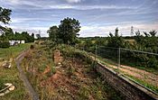
The second site was at Darnford Lane, around lock 29. The council bought this land in 1995 using a special grant for unused land. The third site is at Tamworth Road, covering locks 24 to 26. The upper two sites have been mostly restored. Lock 24 was dug out to check its condition. It was then filled in again to protect it. This is until a decision is made on how the canal will cross Cricket Lane, which is just above the lock. This whole area has been made into a park called Borrowcop Locks Canal Park.
Building the M6 Toll Aqueduct

The building of the M6 Toll motorway around Birmingham threatened the restoration. The motorway cut right across the canal's path. The person in charge of the motorway project decided that the road builders would only create the base for a new aqueduct. This aqueduct would carry the canal over the motorway. The Trust had to raise money for the rest of the structure.
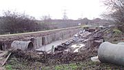
An appeal for funds was started, led by actor David Suchet. With a grant of £250,000 from the Manifold Trust, the total cost of £450,000 was met. The road builders constructed the supporting columns. On August 16, 2003, a large steel trough was lifted into place by a crane. It was built by Rowecord Engineering Ltd from South Wales. The aqueduct is finished, but the canal has not yet reached it, so it looks a bit unusual.
This situation had a good outcome. The Government promised that no new road would ever again be built across a waterway restoration project. They would always provide an aqueduct or tunnel instead.
Recent Restoration Progress
A new bridge carrying Cappers Lane over the canal near Whittington opened on April 21, 2006.
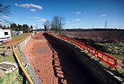
By August 2010, most of the work on a by-wash for lock 25 was done. A by-wash helps control water levels. This work was carried out by members of the Restoration Trust. They also got help from the Waterways Recovery Group during weekend visits. In April 2011, the canal between Lock 25 and 26 was filled with water. This was the first part of the canal to be filled since the restoration began!
- Pound 26 Restoration
-
Lock 25 prior to restoration
-
Lock 25 during restoration
-
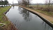
The first part of Lichfield Canal (between Lock 25 and 26) to be re-filled with water (April 2011)


- Restoration at Borrowcop Locks Canal Park 2016-2017
-
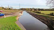
Pound 27 of the Lichfield Canal was completed in November 2016 but will not be fully in water until flood control structures have been agreed with the Environment Agency.
-
The Lichfield Canal in the process of restoration by Lichfield and Hatherton Canals Restoration Trust. This section runs along the A38, where the A51 crosses the route of the canal.
-
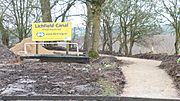
The Heritage Towpath Trail was extended from Borrowcop Locks Canal Park to Cricket Lane in February 2017


Canal Route Highlights
The Lichfield Canal stretches across various landscapes and passes under several important roads and railways. Here are some key points along its route:
- Huddlesford Junction: This is where the canal connects with the Coventry Canal.
- Watery Lane: An old bridge crosses the canal here.
- Cappers Lane: Another bridge that was recently rebuilt.
- Darnford Bridge: A notable crossing point.
- A5 Tamworth Road, Freeford Bridge: A major road crossing.
- A38 road: The canal passes under the busy Lichfield bypass.
- Cross-City Line Rail: The canal goes under this railway line.
- Fosseway Lane: An area where restoration work has taken place.
- Pipehill A451 Walsall Road: Here, the canal meets a disused railway line.
- A461 Walsall Road: Another significant road crossing.
- A5 road, Muckley Corner: A major road junction.
- M6 Toll: The new Lichfield Canal Aqueduct carries the canal over this motorway.
- Ogley Junction: This is where the Lichfield Canal connects with the remaining Wyrley and Essington Canal.
