
Lilongwe facts for kids
Quick facts for kids
Lilongwe
|
|
|---|---|
    From top: Bingu International Conference Centre, K.A.R. Clocktower, National Bank, Malawi Parliament Building
|
|
| Motto(s):
Liľonğwë
|
|

Lilongwe
Location in Malawi

Lilongwe
Location in Africa
|
|
| Country | |
| Region | Central Region |
| District | Lilongwe |
| Area | |
| • Total | 727.79 km2 (281.00 sq mi) |
| Elevation | 1,050 m (3,440 ft) |
| Population
(2018 Census)
National Statistical Office of Malawi |
|
| • Total | 989,318 |
| • Density | 1,482/km2 (3,840/sq mi) |
| Time zone | UTC+02:00 (Central Africa Time) |
| • Summer (DST) | (Not Observed) |
| Climate | Cwa |
| Website | lcc.mw |
Lilongwe is the capital and largest city of Malawi, a country in Africa. About 989,318 people lived here in 2018, and by 2020, the number grew to 1,122,000. The city is in the central part of Malawi, close to the borders of Mozambique and Zambia. Lilongwe is a very important place for business and travel in central Malawi. It gets its name from the Lilongwe River.
Contents
History of Lilongwe
Lilongwe started as a small settlement called a boma around 1902, set up by a local leader named Njewa. By 1904, it became an important administrative center. In the 1920s, its location where several main roads met made it a key market for farm products from the nearby fertile lands.
Becoming a Town and Capital
Lilongwe was officially recognized as a town in 1947. After Malawi became an independent country, Lilongwe grew even more as a major trading hub in the central region. In 1965, Malawi's first president, Hastings Kamuzu Banda, chose Lilongwe to be a main area for economic growth.
Lilongwe became the capital city of Malawi in 1975, taking over from the old capital, Zomba. The last government offices moved to Lilongwe in 2005.
City Growth and Development
During the 1970s and 1980s, many big projects helped Lilongwe grow. These included building the Lilongwe International Airport and creating train links to Salima in the east and the Zambian border in the west. New industrial areas were also built in the northern part of the city. Lilongwe's population is still growing very quickly, with about 4.3% more people each year.
How Lilongwe Was Planned
The first plans for Lilongwe were made in 1955. Later, in 1965, the government decided to move the capital here to make government work more efficient. They also wanted to help the central and northern parts of Malawi grow. The city was designed to have several centers, not just one, to avoid too much traffic and crowding. Each center had homes, jobs, and services nearby, so people would not have to travel far.
The city was planned with a lot of green spaces and a high-quality environment. This was to make it a beautiful and comfortable capital city. Over the years, the city's boundaries have expanded, and new plans have been made to guide its growth. Today, Lilongwe covers an area of 393 square kilometers.
People and Cultures in Lilongwe
The number of people living in Lilongwe has grown a lot, from less than 20,000 in 1966 to almost a million in 2018. This fast growth has led to the development of informal settlements around the city.
Ethnic Groups in Lilongwe
| Ethnic Groups in Lilongwe City (2018 Census) | ||||
|---|---|---|---|---|
| Ethnic Groups | percent | |||
| Chewa | 42.28% | |||
| Ngoni | 17.13% | |||
| Lomwe | 14.48% | |||
| Yao | 12.11% | |||
| Tumbuka | 6.46% | |||
| Mang'anja | 1.86% | |||
| Sena | 1.78% | |||
| Tonga | 1.56% | |||
| Nyanja | 0.67% | |||
| Nkhonde | 0.63% | |||
| Lambya | 0.35% | |||
| Sukwa | 0.04% | |||
| Other | 0.64% | |||
According to the 2018 census, the largest ethnic group in Lilongwe City is the Chewa, making up about 42% of the population. The next largest group is the Ngoni, with about 17%. Other groups include the Lomwe, Yao, and Tumbuka.
Religions in Lilongwe
Religions in Lilongwe City (2018 Census) Church of Central Africa Presbyterian (23.15%) Catholic (17.28%) Seventh-day Adventist/Baptist/Apostolic (10.35%) Pentecostal (8.6%) Anglican (2.31%) Other Christian (21.67%) Muslim (11.12%) Traditional (0.34%) Other (3.38%) No Religion (1.73%)
The most common religion in Lilongwe City is the Church of Central Africa Presbyterian, followed by Catholicism. Many other Christian groups are also present, such as Seventh-day Adventist and Pentecostal churches. About 11% of the population practices Islam.
Geography and Layout of Lilongwe
Lilongwe is located on a high flat area, or plateau, in central Malawi. It is part of the East African Rift Valley and sits about 1,050 meters (3,440 feet) above sea level, along the Lilongwe River.
City Sections
Lilongwe is split into two main parts: the New City and the Old City. The New City has modern hotels, government buildings, and offices. The Old City is where you will find busy markets, bus stations, and local cafes. The city has a mix of modern shops and traditional street markets.
Residential Areas
Lilongwe has different areas for homes, from low-density (fewer homes spread out) to high-density (many homes close together, like apartments). For example, Area 12 is mostly for low-density housing. Areas like 7, 18, and 21 have a lot of high-density housing. There are also areas with high-rise flats, like Area 17.
Commercial Areas
Commercial areas are where businesses are located. The city center has "High-Rise Commercial" zones with tall buildings. The Old Town also has many commercial businesses. These areas are often mixed with residential zones to make the city efficient.
Industrial Areas
Industrial areas are for factories and businesses that make things. Lilongwe has two types: "heavy/large-scale industries" in the Kanengo area and "light industries." These industrial zones are generally kept separate from the main commercial areas.
Green Spaces and Parks
Lilongwe has many open spaces and green areas. These include natural sanctuaries, parks, and places for recreation. There is even a Natural Sanctuary right in the middle of the city, which is protected for future generations.
How the City is Divided

Lilongwe is divided into numbered "Areas." These numbers were given in order, not based on where they are located. The main built-up part of Lilongwe forms an oval shape around the Old Town and the City Centre. The city is made up of Areas 1 through 58. New housing and urban growth are very active, especially in the southern parts of the city.
Lilongwe's Climate
Lilongwe has a warm climate with pleasant summers and mild winters. Because it is high up, the temperatures are cooler than you might expect for a city in the tropics. Lilongwe has a short rainy season from December to March, a long dry winter from April to August, and a warm summer from September to November. During the rainy season, the city gets a lot of rain.
| Climate data for Lilongwe (1991-2020, extremes 1981–present) | |||||||||||||
|---|---|---|---|---|---|---|---|---|---|---|---|---|---|
| Month | Jan | Feb | Mar | Apr | May | Jun | Jul | Aug | Sep | Oct | Nov | Dec | Year |
| Record high °C (°F) | 32.5 (90.5) |
31.2 (88.2) |
30.2 (86.4) |
30.5 (86.9) |
31.5 (88.7) |
28.0 (82.4) |
29.2 (84.6) |
29.5 (85.1) |
33.1 (91.6) |
34.5 (94.1) |
34.2 (93.6) |
32.4 (90.3) |
34.5 (94.1) |
| Mean daily maximum °C (°F) | 26.2 (79.2) |
26.3 (79.3) |
26.3 (79.3) |
25.9 (78.6) |
25.5 (77.9) |
23.5 (74.3) |
22.5 (72.5) |
24.5 (76.1) |
27.2 (81.0) |
29.5 (85.1) |
29.3 (84.7) |
27.7 (81.9) |
26.3 (79.3) |
| Daily mean °C (°F) | 22.0 (71.6) |
21.8 (71.2) |
21.7 (71.1) |
20.3 (68.5) |
18.5 (65.3) |
16.3 (61.3) |
15.4 (59.7) |
17.3 (63.1) |
20.1 (68.2) |
22.6 (72.7) |
23.5 (74.3) |
22.9 (73.2) |
20.2 (68.4) |
| Mean daily minimum °C (°F) | 17.9 (64.2) |
17.5 (63.5) |
17.1 (62.8) |
14.9 (58.8) |
11.9 (53.4) |
9.2 (48.6) |
8.6 (47.5) |
10.3 (50.5) |
13.3 (55.9) |
16.3 (61.3) |
17.9 (64.2) |
18.0 (64.4) |
14.4 (57.9) |
| Record low °C (°F) | 11.8 (53.2) |
11.7 (53.1) |
11.3 (52.3) |
8.1 (46.6) |
3.0 (37.4) |
0.5 (32.9) |
−0.6 (30.9) |
1.4 (34.5) |
5.1 (41.2) |
7.9 (46.2) |
10.0 (50.0) |
11.8 (53.2) |
−0.6 (30.9) |
| Average precipitation mm (inches) | 223 (8.8) |
187 (7.4) |
128 (5.0) |
44 (1.7) |
12 (0.5) |
1 (0.0) |
0 (0) |
0 (0) |
1 (0.0) |
10 (0.4) |
63 (2.5) |
199 (7.8) |
869 (34.2) |
| Average precipitation days (≥ 0.1 mm) | 18 | 16 | 15 | 8 | 4 | 1 | 1 | 1 | 0 | 2 | 8 | 17 | 91 |
| Average relative humidity (%) | 83 | 83 | 82 | 78 | 74 | 69 | 65 | 60 | 52 | 53 | 62 | 78 | 69 |
| Mean monthly sunshine hours | 140.1 | 159.6 | 198.2 | 214.6 | 260.1 | 233.8 | 295.1 | 285.7 | 279.0 | 306.6 | 236.6 | 164.5 | 2,688 |
| Mean daily sunshine hours | 4.4 | 5.1 | 5.5 | 7.1 | 8.5 | 8.1 | 7.8 | 8.5 | 9.8 | 9.1 | 7.8 | 4.5 | 7.2 |
| Source 1: Meteo Climat, Extreme Temperature Around The World | |||||||||||||
| Source 2: Deutscher Wetterdienst (precipitation 1961-1990, precipitation days, humidity 1982-1990, daily sun 1975-1986) | |||||||||||||
Economy and Jobs in Lilongwe
Even though Blantyre is Malawi's main business city, Lilongwe's economy is mostly driven by the government and public organizations. The Kanengo area in the north is the main industrial zone. Here, you'll find businesses that process food, store and sell tobacco, and store maize.
The main jobs in Lilongwe are in finance, banking, retail, construction, transportation, public administration, tourism, and tobacco manufacturing. About 76% of Lilongwe's people live in informal settlements. Around 25% of the population lives in poverty, and 16% are unemployed. Many people work for the government or in the private sector.
Getting Around Lilongwe
Airport Travel

The Kamuzu International Airport (LLW) is located north of the city, about 7 kilometers from the city center. It is the country's oldest airport.
Bus Services
You can take regular buses from Lilongwe to other cities in Malawi like Blantyre, Zomba, Kasungu, and Mzuzu. There are also international buses that go to South Africa, Zambia, and Tanzania every day.
The city has a good road network. There is a main north-south road (M1), an inner ring road, and an outer ring road. These roads help connect different parts of the city and reduce traffic in the main areas.
Train Connections
Lilongwe also has train services. A train line goes west towards Zambia, and another goes east to Salima.
Education in Lilongwe

The University of Malawi was started in 1964. Lilongwe has many schools for children. There are 38 private schools and 66 public primary schools, teaching over 103,000 students. The city also has 29 secondary schools with more than 30,000 students.
Places to Worship
In Lilongwe, you will find many places of worship. Most of them are Christian churches, such as the Lutheran Church of Central Africa, the Church of Central Africa Presbyterian, and the Roman Catholic Archdiocese of Lilongwe. There are also Muslim mosques in the city.
Sports in Lilongwe

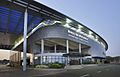
Lilongwe has a large national stadium called Bingu National Stadium, which can hold 40,000 people. It was opened in 2017. Other football stadiums include Silver Stadium, Civo Stadium, and Nankhaka Ground. Popular football teams in Lilongwe are Silver Strikers, Civo Sporting, Blue Eagles, and Kamuzu Barracks.
Basketball is played at places like African Bible College and Don Bosco. Netball is also a popular sport, played at Gateway Mall and other locations. The city also has a Rugby Union competition with several teams.
Sister Cities
Lilongwe is connected with other cities around the world as "sister cities." These partnerships help promote cultural exchange and friendship.
Images for kids
-
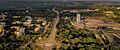
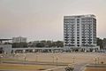
Bird's eye view of Lilongwe
-
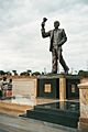
Hastings Kamuzu Banda statue in Lilongwe
-
Bingu International Conference Centre
-
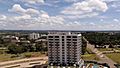
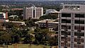
Lilongwe city from capital hill
-
Lilongwe city centre
-
Lilongwe city from the sky


See also
 In Spanish: Lilongüe para niños
