
Limavady Borough Council facts for kids
Quick facts for kids Limavady Borough
|
|
|---|---|
 |
|
| Area | 586 km2 (226 sq mi) Ranked 10th of 26 |
| District HQ | Limavady |
| Catholic | 56.6% |
| Protestant | 41.6% |
| Country | Northern Ireland |
| Sovereign state | United Kingdom |
| EU Parliament | Northern Ireland |
| Councillors |
|
The Limavady Borough Council (which in Irish is called Comhairle Bhuirg Léim an Mhadaidh) was a local government group in Northern Ireland. Think of it like a local team that made decisions for the Limavady area.
This council looked after things like local services and planning for the people living there. In May 2015, the Limavady Borough Council joined up with three other councils: Coleraine Borough Council, Ballymoney Borough Council, and Moyle District Council. Together, they formed a new, bigger council called the Causeway Coast and Glens District Council.
The main office for the Limavady Borough Council was in the town of Limavady. Even though the office was in town, most people (about 63%) lived in the countryside. The area covered by the council was quite large, about 586 square kilometers. It included the beautiful valley of the River Roe. The area stretched from the Sperrin Mountains in the south all the way to Benone beach. Benone beach is a seven-mile long sandy stretch on the Atlantic coast. It was the first beach in Northern Ireland to earn a special award called a Blue Flag. Besides Limavady, other important towns in the area were Dungiven and Ballykelly.
Contents
How the Council Worked
The Limavady Borough Council area was split into three voting areas. These were Limavady Town, Benbradagh, and Bellarena. The council started in 1973. It had 15 members who were chosen by local people in elections. These members usually served for four years. They were elected using a special voting method called the single transferable vote system.
The Limavady area, along with the nearby district of Coleraine, formed a larger area for national elections. This area was known as the East Londonderry constituency. People from this constituency voted for members to go to the Westminster Parliament in London and the Northern Ireland Assembly in Belfast.
Council Members and Elections
In the last election held in 2011, members from several different political parties were chosen to be part of the council.
- Sinn Féin had 6 members.
- The Social Democratic and Labour Party (SDLP) had 3 members.
- The Democratic Unionist Party (DUP) had 3 members.
- The Ulster Unionist Party (UUP) had 2 members.
- The Traditional Unionist Voice (TUV) had 1 member.
The council also had a Mayor and a Deputy Mayor. These important roles were usually rotated each year. This rotation happened between members from the two main community groups in the area. This was part of how the council worked together. For example, in June 2013, Councillor Gerry Mullan from the SDLP was the Mayor, and Councillor James McCorkell from the DUP was the Deputy Mayor.
Changes to Local Government
There was a big plan called the Review of Public Administration (RPA). This plan aimed to combine many smaller councils into fewer, larger ones. Under this plan, Limavady Borough Council was supposed to merge with Coleraine, Ballymoney, and Moyle councils in 2011. This would create the Causeway Coast and Glens District Council. This new council would cover a much larger area of 1796 square kilometers and have a population of about 131,564 people.
The next local elections were planned for May 2009. However, on April 25, 2008, a government official named Shaun Woodward announced a delay. He said the council elections would be postponed until the new, larger councils were ready in 2011. But the plan to create the new councils faced some delays. So, the 26 existing councils, including Limavady, stayed in place. Elections were held in May 2011 for these councils, for what everyone thought would be their last term.
Population of Limavady Borough
According to the 2011 Northern Ireland census, the area that Limavady Borough Council covered had 33,536 people living there.
Images for kids
-
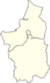
A map showing the different voting areas of Limavady Borough from 1993 to 2014.

