Lime, Oregon facts for kids
Quick facts for kids
Lime, Oregon
|
|
|---|---|

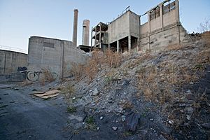
Abandoned cement plant at Lime,
circa 2012 |
|
| Country | United States |
| State | Oregon |
| County | Baker |
| Elevation | 2,234 ft (681 m) |
| Time zone | UTC-8 (Pacific (PST)) |
| • Summer (DST) | UTC-7 (PDT) |
| Area code(s) | 458 and 541 |
| GNIS feature ID | 1167713 |
Lime is a small, quiet place in Baker County, Oregon, in the northwest United States. It's known as an unincorporated community, which means it doesn't have its own local government like a city. It's also considered a ghost town because most people have moved away. You can find Lime about 5 miles north of Huntington, right next to Interstate 84 and U.S. Route 30. It's also close to where Marble Creek meets the Burnt River. The famous historic Oregon Trail even passes through this area.
History of Lime
The town of Lime got its name from the large amounts of limestone found nearby. Limestone is a type of rock used to make building materials. In 1899, a post office was opened in Lime.
Cement Production
The limestone in the area was used to make lime, which was then sent to many places in Eastern Oregon and western Idaho. In 1916, a company called Acme Cement Plaster Company built a factory in Lime. They used the limestone to make plaster.
Later, in 1921, another company called Sun Portland Cement Company bought the factory. They built a new part of the plant to make Portland cement. This is a special type of cement used in concrete. In 1926, Sun Portland Cement Company joined with the Oregon Portland Cement Company. By the 1960s, the factory in Lime was very busy. It made 1,200,000 barrels of cement every year!
Town's Peak and Decline
At its busiest time in 1940, Lime had a population of 18 people. But as time went on, the town started to get smaller. The post office, which was an important part of the community, closed in 1964.
The limestone deposits near Lime eventually started to run out. So, the company had to bring limestone from another area called Nelson, near Durkee. In 1979, a brand new cement plant was built in Nelson. Because of this, the old factory in Lime was closed down in 1980. A few years later, in 1983, Oregon Portland Cement Company became part of the Ash Grove Cement Company.
Recent Years
In 1999, Baker County took over the land where the old factory stood because of unpaid taxes. In 2018, plans were made to tear down the old cement plant. Crews arrived in April of that year to begin the demolition work.
 | Laphonza Butler |
 | Daisy Bates |
 | Elizabeth Piper Ensley |


