
Limestone, Maine facts for kids
Quick facts for kids
Limestone, Maine
|
||
|---|---|---|
 |
||
|
||
| Motto(s):
"Experience our quality of life"
|
||

Location of Limestone, Maine
|
||
| Country | United States | |
| State | Maine | |
| County | Aroostook | |
| Village | Limestone | |
| Area | ||
| • Total | 40.79 sq mi (105.65 km2) | |
| • Land | 40.49 sq mi (104.87 km2) | |
| • Water | 0.30 sq mi (0.78 km2) | |
| Elevation | 521 ft (159 m) | |
| Population
(2020)
|
||
| • Total | 1,526 | |
| • Density | 38/sq mi (14.6/km2) | |
| Time zone | Eastern (EST) | |
| ZIP code |
04750
|
|
| Area code(s) | 207 | |
| GNIS feature ID | Eastern (EST) | |

Limestone is a town located in Aroostook County, Maine, in the United States. In 2020, about 1,526 people lived there.
Limestone is famous for the Loring Commerce Centre, which used to be a big air force base. It's also home to the Maine School of Science and Mathematics (MSSM). This school was ranked as the second-best in the United States in 2019!
The main part of the town, where most people live, is called Limestone (CDP). It's in the east-central area of the town.
Contents
History of Limestone
Mark Trafton, born in 1785, was the first person to settle in Limestone in 1849. He worked as a customs officer for Fort Fairfield. Later, in the early 1850s, Trafton served in the Maine House of Representatives.
In 1846, three years before settling, Mark Trafton, his son, and a friend started the Limestone Mill Company. The town of Limestone officially became a town on March 17, 1869. It was named Limestone because of the natural limestone found in the area.
In 1952, the United States Air Force opened Loring Air Force Base near Limestone. This base caused the town's population to grow a lot. In 1960, Limestone had its highest population ever, with 13,102 people.
However, the Loring Air Force Base closed on September 30, 1994. This happened after a special commission recommended it. After the base closed, the Maine School of Science and Mathematics opened there in 1995. It is a public high school for talented students who want to focus on math and science.
The Wall Street Journal reported in 2024 that Limestone had to cut back on public services after the base closed. For example, its police department closed in 2023. The town has also had many different town managers since the mid-2010s.
Geography and Climate
According to the United States Census Bureau, Limestone covers a total area of about 40.79 square miles (105.65 square kilometers). Most of this area, about 40.49 square miles (104.87 square kilometers), is land. The rest, about 0.30 square miles (0.78 square kilometers), is water.
Limestone's Weather Patterns
Limestone experiences big changes in temperature throughout the year. Summers are usually warm to hot and can be humid. Winters are very cold, sometimes extremely cold.
According to the Köppen Climate Classification system, Limestone has a humid continental climate. This type of climate is often shown as "Dfb" on climate maps.
| Climate data for Limestone 4 NNW, Maine, 1991–2020 normals, 2002–2024 extremes: 737ft (225m) | |||||||||||||
|---|---|---|---|---|---|---|---|---|---|---|---|---|---|
| Month | Jan | Feb | Mar | Apr | May | Jun | Jul | Aug | Sep | Oct | Nov | Dec | Year |
| Record high °F (°C) | 52 (11) |
50 (10) |
73 (23) |
81 (27) |
91 (33) |
94 (34) |
92 (33) |
90 (32) |
90 (32) |
81 (27) |
73 (23) |
58 (14) |
94 (34) |
| Mean maximum °F (°C) | 41.4 (5.2) |
40.9 (4.9) |
49.4 (9.7) |
66.7 (19.3) |
82.9 (28.3) |
85.2 (29.6) |
86.9 (30.5) |
85.3 (29.6) |
81.3 (27.4) |
71.8 (22.1) |
59.6 (15.3) |
46.9 (8.3) |
87.1 (30.6) |
| Mean daily maximum °F (°C) | 19.4 (−7.0) |
22.5 (−5.3) |
32.8 (0.4) |
45.8 (7.7) |
61.4 (16.3) |
70.2 (21.2) |
74.5 (23.6) |
73.8 (23.2) |
65.7 (18.7) |
51.1 (10.6) |
38.1 (3.4) |
26.4 (−3.1) |
48.5 (9.1) |
| Daily mean °F (°C) | 9.4 (−12.6) |
11.8 (−11.2) |
23.0 (−5.0) |
36.5 (2.5) |
50.1 (10.1) |
59.2 (15.1) |
64.3 (17.9) |
62.9 (17.2) |
54.7 (12.6) |
42.3 (5.7) |
30.7 (−0.7) |
18.0 (−7.8) |
38.6 (3.7) |
| Mean daily minimum °F (°C) | −0.6 (−18.1) |
1.1 (−17.2) |
13.1 (−10.5) |
27.1 (−2.7) |
38.8 (3.8) |
48.2 (9.0) |
54.1 (12.3) |
52.1 (11.2) |
43.7 (6.5) |
33.6 (0.9) |
23.3 (−4.8) |
9.5 (−12.5) |
28.7 (−1.8) |
| Mean minimum °F (°C) | −22.2 (−30.1) |
−21.3 (−29.6) |
−11.7 (−24.3) |
11.4 (−11.4) |
27.1 (−2.7) |
36.5 (2.5) |
43.1 (6.2) |
41.2 (5.1) |
30.0 (−1.1) |
20.9 (−6.2) |
4.9 (−15.1) |
−12.2 (−24.6) |
−24.7 (−31.5) |
| Record low °F (°C) | −38 (−39) |
−28 (−33) |
−25 (−32) |
−5 (−21) |
24 (−4) |
30 (−1) |
37 (3) |
36 (2) |
24 (−4) |
12 (−11) |
−5 (−21) |
−26 (−32) |
−38 (−39) |
| Average precipitation inches (mm) | 3.38 (86) |
2.62 (67) |
3.05 (77) |
3.28 (83) |
3.66 (93) |
3.83 (97) |
4.14 (105) |
3.92 (100) |
3.78 (96) |
4.06 (103) |
3.52 (89) |
3.84 (98) |
43.08 (1,094) |
| Average snowfall inches (cm) | 22.3 (57) |
24.1 (61) |
18.6 (47) |
6.5 (17) |
1.1 (2.8) |
0.0 (0.0) |
0.0 (0.0) |
0.0 (0.0) |
0.1 (0.25) |
3.2 (8.1) |
9.4 (24) |
21.5 (55) |
106.8 (272.15) |
| Average precipitation days (≥ 0.01 in) | 16.5 | 14.5 | 14.2 | 15.0 | 15.3 | 15.2 | 14.7 | 14.4 | 11.7 | 14.2 | 14.4 | 18.4 | 178.5 |
| Average snowy days (≥ 0.1 in) | 13.4 | 12.4 | 10.6 | 4.6 | 0.8 | 0.0 | 0.0 | 0.0 | 0.2 | 1.9 | 7.6 | 13.2 | 64.7 |
| Source 1: NOAA | |||||||||||||
| Source 2: XMACIS2 (extremes & Limestone Loring AFB 1951-1970 snow) | |||||||||||||
Population and People
| Historical population | |||
|---|---|---|---|
| Census | Pop. | %± | |
| 1860 | 161 | — | |
| 1870 | 263 | 63.4% | |
| 1880 | 655 | 149.0% | |
| 1890 | 933 | 42.4% | |
| 1900 | 1,131 | 21.2% | |
| 1910 | 1,293 | 14.3% | |
| 1920 | 1,506 | 16.5% | |
| 1930 | 1,953 | 29.7% | |
| 1940 | 1,855 | −5.0% | |
| 1950 | 2,427 | 30.8% | |
| 1960 | 13,102 | 439.8% | |
| 1970 | 8,745 | −33.3% | |
| 1980 | 8,719 | −0.3% | |
| 1990 | 9,922 | 13.8% | |
| 2000 | 2,361 | −76.2% | |
| 2010 | 2,314 | −2.0% | |
| 2020 | 1,526 | −34.1% | |
| U.S. Decennial Census | |||
2010 Census Information
In 2010, a census showed that 2,314 people lived in Limestone. There were 809 households and 489 families. The population density was about 57.1 people per square mile.
Most of the people living in Limestone were White (89.2%). There were also African American (7.0%), Native American (1.3%), and Asian (0.7%) residents. About 3.8% of the population was Hispanic or Latino.
About 24.7% of households had children under 18. Many households (45.5%) were married couples. About 12.6% of households had someone aged 65 or older living alone. The average household had 2.21 people.
The average age of people in Limestone was 34.7 years. About 22% of residents were under 18. About 15.1% were 65 years or older. The town had slightly more males (53.5%) than females (46.5%).
Economy and Attractions
Loring Commerce Centre
Limestone used to be home to the Loring Air Force Base. After it closed in 1994, the area became famous for hosting three large music festivals by the band Phish. Thousands of fans came to Limestone, making it the most populated town in Maine for those weekends.
Today, the former base is known as the Loring Commerce Centre. It is one of Maine's biggest industrial parks.
Natural Attractions
Limestone is home to the Aroostook National Wildlife Refuge. This is a special place where wildlife is protected.
Education in Limestone
The town is proud to host the Maine School of Science and Mathematics. This is a special high school where students live and focus on math and science. It was once ranked as the second-best school in the United States.
Limestone also has the Loring Job Corps Center. This center helps young people get job training and education. It is located on part of the old Loring Air Force Base.
Notable People from Limestone
- Steve Bartalo – An American football player.
- Conrad Keefe Cyr – A federal judge who worked in appellate courts.
Images for kids
-
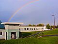
A double rainbow over Limestone, Maine.
-

The flag of Limestone, Maine.
-
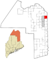
A map showing the location of Limestone, Maine.
See also
 In Spanish: Limestone (Maine) para niños
