
Lincoln Highway (Omaha) facts for kids
Quick facts for kids
[[File:|x70px|alt= marker]] |
|
|---|---|
|
Old Lincoln Highway highlighted in red
|
|
| Highway system | |
| Nebraska Highways | |
|
Lincoln Highway (Omaha)
|
|
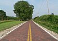
.JPG)
Brick-paved section of Lincoln Highway in West Omaha near Elkhorn.
|
|
| Location | Omaha, Nebraska |
| Built | 1913 |
| NRHP reference No. | 03000104 |
| Added to NRHP | 2003 |
The Lincoln Highway was the very first road to stretch all the way across the United States. It connected Times Square in New York City on the East Coast to Lincoln Park in San Francisco, California on the West Coast.
The Lincoln Highway in Omaha, Nebraska, is a special part of this historic road. It runs from near North 183rd Street and West Dodge Road in Omaha, Nebraska, all the way to North 192nd Street near Elkhorn. This section is about 20 miles (32 km) long and is one of the few parts of the highway in Nebraska that was paved with bricks. It's also one of the best-preserved sections of the Lincoln Highway anywhere in the country! Because of its importance, this roadway was added to the National Register of Historic Places in 1984.
Contents
Building the Lincoln Highway in Omaha
The original Lincoln Highway section in Omaha was built in 1913. It was a big deal because it helped connect people and places across the country.
When the highway first reached Omaha, it crossed the Missouri River on the old Douglas Street Bridge. Then, it traveled west on Dodge Street. From there, it wound its way across Nebraska, often following straight lines that divided land sections.
A Change of Route
Things changed in 1929 when the Abraham Lincoln Memorial Bridge was built near Blair. The next year, the Lincoln Highway was rerouted. It started following U.S. 30 through Blair instead of going through Omaha.
This rerouting caused some tension! Officials from Blair came to Omaha and dug up the Lincoln Highway markers. They then put these markers in their own town. This made people in Omaha very upset and created a long-lasting rivalry with Blair.
Even though the Omaha section was no longer the main route, this change actually helped preserve it. Less traffic meant the road didn't wear out as quickly. This is why we can still enjoy and appreciate it today!
Important Places Along the Highway
Many important buildings and attractions were located along the Lincoln Highway in Omaha. These places were part of the city's history and served travelers on the highway.
Historic Buildings and Businesses
- The Nash Block was a group of buildings at 902-912 Farnam and 901-911 Douglas streets.
- The Blackstone Hotel stood at Farnam Street and 36th Street.
- The Rose Blumkin Performance Arts Center is located at 20th and Farnam Street.
- The Farnam Street Automobile Row, from 30th to 40th Streets, was a place where many car dealerships were located.
Other Attractions and Landmarks
- Jobber's Canyon was a large area of warehouses downtown. It used to supply goods to people heading out to the Old West.
- Peony Park was a popular amusement park. In the 1930s, famous musicians like Lawrence Welk's orchestra played there.
- The Guy Barton Mansion was a grand house built in 1892. It was taken down in 1982.
- The Hupmobile dealership at 25th and Farnam is the last preserved Hupmobile car dealership in the United States.
- John Sutter's Mill was built in 1847. It was a landmark at the intersection of Saddle Creek Road and Dodge Street. This mill was important even before the nearby towns of Dundee and Benson were officially formed.
Keeping the Highway Safe
People in Omaha have worked hard to protect this historic road.
In 1975, the Douglas County Board of Commissioners decided to keep the roadway in good condition. Later, in the 1980s, there were plans to cover the brick road with asphalt. But people who cared about history pushed to restore the highway instead.
Eventually, the section was repaired using the original bricks that were laid in 1920. To protect the old brickwork, large vehicles weighing 6 tons or more are now not allowed on this part of the highway. This helps keep the road in great shape for future generations.
What's There Today
Today, you can still visit and learn about the Lincoln Highway in Omaha.
There's a special pull-off area maintained by the Omaha Public Power District where you can stop and read about the highway. You can also see a rebuilt pony truss bridge that crosses the West Papillion Creek.
Seven historical markers are placed along the roadway. One monument was put up in 1987 by the Elkhorn Lincoln Highway Diamond Jubilee Committee. It has a historic plaque and two copies of the original 1928 Lincoln Highway markers.
The city of Omaha has also planned to improve the roadway. They want to add a 0.75-mile (1.21 km) paved trail next to the highway. They also plan to put up informational kiosks. This trail would be the farthest west trail in Omaha. The Omaha government has already bought the land needed for this new trail.
How to Follow the Old Route
If you want to explore the historic Lincoln Highway in Omaha, here's how you can do it, according to the Lincoln Highway Association:
- Start by exiting I-480 at Dodge Street.
- Follow Dodge Street westward. It will eventually become West Dodge Road.
- At the 180th Street exit, turn north onto 180th Street.
- Continue on 180th Street until it ends at the Old Lincoln Highway.
- Take this paved section of the highway north, driving along the original bricks.
- When you reach the underpass with North 204th Street, take East Park Road to Main Street.
- Then, turn west onto Elkhorn Drive.
- At the intersection with West Maple Road, turn west again.
- After 2.2 miles, merge onto US-275 and you will leave Douglas County.
The next part of the highway was added to the National Register of Historic Places in 2003, showing its continued importance.
Images for kids
-
Brick-paved section of Lincoln Highway in West Omaha near Elkhorn.
