Trails in Omaha facts for kids

Trails in Omaha, Nebraska are awesome paths for walking, running, and biking! Omaha has about 80 miles (129 km) of paved trails. There are also many unpaved paths for fun outdoor activities. These trails are super popular with people who love to bike, run, or just take a walk. They are a big part of plans for the City of Omaha and the areas around it.
Contents
History of Omaha's Trails
Did you know that way back in 1887, the Omaha Bicycling Club helped make a special track for bicycle racing? There were other early trails too. But for many years in the 1900s, Omaha didn't have many trails.
That changed in 1989 when the city started building the Keystone Trail. Since then, Omaha has built about 67 miles (108 km) of paved trails. Even more trails, about 35 miles (56 km), are planned for the future!
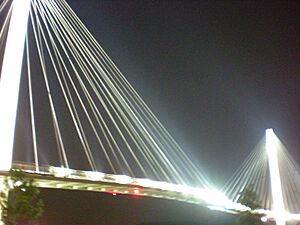
A really cool thing happened on September 28, 2008. Omaha's trails got connected to trails in Council Bluffs, Iowa. This happened thanks to the new Bob Kerrey Pedestrian Bridge. This bridge is super long, over 3,000 feet (914 m) across the Missouri River. It links Omaha's Riverfront Trail with Playland Park in Council Bluffs.
Why Omaha's Trails Are Great
Trails in Omaha offer many cool benefits. A recent study looked at how people feel about them. Most people think the trails are good for the economy. Almost two-thirds of those asked said trails would make their homes worth more money.
People also feel safe on the trails. Problems like trespassing or theft by trail users don't happen very often. Most people who live near the trails believe they make their neighborhood a better place to live. So, trails are good for fun, health, and even your neighborhood!
Future Plans for Trails
There are many exciting plans for Omaha's trails. A local group wants more trails that go from east to west. Right now, the eastern part of the city doesn't have many trails.
There are also plans to connect Omaha to the MoPac Trail. This trail starts in Lincoln, Nebraska. The idea is to link Omaha to this trail system. It will eventually connect to the 144th Street Trail.
The trails are also part of a huge project called the Quad State Trail Project. Imagine linking cities in Nebraska, Iowa, Kansas, and Missouri! This plan wants to connect Omaha to places like St. Louis, Kansas City, and Topeka. This would create 700 miles (1,127 km) of trails. A lot of these trails, about 450 miles (724 km), already exist!
Explore Omaha's Trails
| Trails in Omaha (Alphabetical Order) | |||||
|---|---|---|---|---|---|
| Name | What to Know | ||||
| 144th Street Trail | Starts at Standing Bear Lake and connects to the Mopac Trail. | ||||
| American Discovery Trail | This big trail comes into Omaha over the South Omaha Bridge. It follows the Riverfront South Trail to Haworth Park. It connects to many other trails there. | ||||
| Big Papio Trail | Follows the Papillion Creek for 10 miles (16 km) and meets the Keystone Trail. | ||||
| Field Club Trail | A 1.72-mile (2.77 km) trail that goes through the Field Club neighborhood. | ||||
| Fontenelle Forest Nature Center | Has 26 miles (42 km) of trails through forests, prairies, and wetlands. It's located in Bellevue. | ||||
| Keystone Trail | Runs from north to south, passing the College of Saint Mary. It connects with the West Papio trail and ends in Bellevue. | ||||
| Lewis and Clark National Historic Trail | This super long trail is headquartered in Omaha. It stretches 3,700 miles (5,955 km) through many western states. | ||||
| Military Road Trail | Runs from east to west, from North 90th Street to North 126th Street. | ||||
| Newport Landing Trail | Goes around the Newport Landing housing area near Bennington. | ||||
| Neale Woods Nature Center | A large area of woodlands and restored prairie north of Omaha. | ||||
| Omaha Riverfront North Trail | Runs along the river from the northern end of Florence Boulevard to Dodge Park. | ||||
| Omaha Riverfront South Trail | Runs along the Missouri River, passing by parks and buildings. | ||||
| Q Street Bike Path | Runs from east to west and connects to the 144th Street Trail. | ||||
| Sorenson Parkway Trail | Runs from east to west along Sorenson Parkway. | ||||
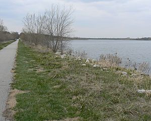
| Standing Bear Lake Trail | A loop trail that goes all the way around Standing Bear Lake. | ||||
| South Omaha Trail | Runs from east to west, connecting the Keystone trail to the Field Club. | ||||
| Swanson Park | Located in Bellevue, this trail is great for mountain biking. It has 6 miles (10 km) of special trails. | ||||
| Tranquility Park | Omaha's first approved off-road trail system in a city park. | ||||
| Turner Boulevard | A 1.4-mile (2.3 km) trail that links the Field Club Trail to Turner Park. It goes through several neighborhoods. | ||||
| Walnut Creek Trail | A trail around the lake at the Walnut Creek Recreation Area. It connects with the West Papio Trail. | ||||
| Walnut Grove Trail | In a small park, this trail connects to both the Zorinsky Lake Trail and the Q Street bike path. | ||||
| Wehrspann Lake Trail | Located in the Chalco Hills Recreation Area. This trail includes Wehrspann Lake and connects to the 144th Street Trail. | ||||
| Westin Hills Trail | Runs from east to west and connects the 144th Street Trail to the West Papio Trail. | ||||
| West Papio North Trail | Runs from north to south. It then splits, going west to Zorinsky Lake and east to the 144th Street Trail. | ||||
| West Papio South Trail | Runs from west to east and connects with the Keystone Trail. | ||||
| Zorinsky Lake Trail | Located near South 168th Street. | ||||
 | Bayard Rustin |
 | Jeannette Carter |
 | Jeremiah A. Brown |


