Lincoln Highway in Greene County, Iowa facts for kids
Quick facts for kids |
|
|
The Lincoln Highway in
Greene County, Iowa |
|
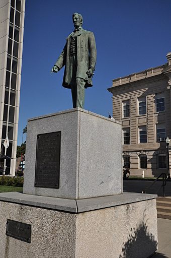
The Lincoln statue in Jefferson.
|
|
| Location | Greene County, Iowa |
|---|---|
| MPS | The Lincoln Highway in Greene County, Iowa MPS |
| NRHP reference No. | 64500168 |
| Added to NRHP | March 29, 1993 |
The Lincoln Highway in Greene County, Iowa is a special collection of historic places. These places are listed on the National Register of Historic Places. This list was approved on March 29, 1993.
It includes five single historic spots and five historic areas. All of them are found in Greene County, Iowa, United States. These spots include old dirt roads that are no longer used. They also include paved roads that are now part of other highways. Plus, there are different objects, buildings, and structures that were once part of the famous Lincoln Highway. The most important years for these sites are from 1912 to 1928.
Contents
The Amazing Lincoln Highway
Imagine a time when there were no good roads to drive across America! That's where Carl Fisher comes in. He was a smart American businessman. In 1912, he had a big idea: to build the first highway that would cross the entire United States. This amazing road would connect New York City all the way to San Francisco.
Building a Road Across America
The plan to build the Lincoln Highway was announced in 1913. People in Iowa were very excited! They raised over $5 million to help build the road. There weren't many good roads in Iowa back then. But the Lincoln Highway Association wanted a direct path between Chicago and Omaha.
So, on September 14, 1913, they announced the route through Iowa. They picked a path already used by drivers crossing the country. This route covered 358 miles (576 km) of dirt and gravel roads. It started in Clinton and went west to Council Bluffs. Iowa's rural roads were known for being very muddy when it rained. The chosen route followed the Chicago Northwestern Railroad tracks. This was because the tracks usually followed the driest and flattest land.
The Highway's Changing Names
In Iowa, the Lincoln Highway was also called State Primary Road No. 6. This was from 1920 to 1926. Then, the federal highway system was created. The road's name changed again in 1926. It became known as U.S. 30.
The Lincoln Highway Association worked until 1927. But the next year, they put up special memorial markers along the route. The old Lincoln Highway stayed a very important road in Iowa. It was used a lot until the 1950s. That's when the state built a new US Highway 30.
Lincoln Highway in Greene County
Greene County was known for having good roads early in the 1900s. It was even the first Iowa county to get mail delivered to homes in rural areas! By 1907, the county had 20 strong bridges. By 1909, it had 175 miles (282 km) of gravel roads.
Greene County's Dedication
The same year the Lincoln Highway route was announced, Greene County made an official road system. This system connected all the towns in the county. People in Greene County worked hard to raise money. They wanted to improve the Lincoln Highway as it passed through their area.
In 1914, the county spent $15,000 to make the road better. Citizens raised another $5,000! In 1918, a statue of Abraham Lincoln was placed in the courthouse square. It was a gift from E.B. and Minnie Wilson. This statue was put there to celebrate the highway.
Paving the Way
Greene County was the first county to accept money from the government to pave roads. This happened in 1919. The very first section of the Lincoln Highway paved in Iowa was near Marion. But Greene County was the first county to pave its entire part of the highway.
The first paved section was 6.5 miles (10.5 km) long. It was located equally far from the center of Jefferson. By 1924, all 30 miles (48 km) of the highway in Greene County were paved. The route through Greene County changed a few times between 1913 and 1924. This happened as road design improved. Curves were made straighter, hills were leveled, and dangerous railroad crossings were avoided.
Special Spots Along the Highway
Lincoln Highway Markers
Lincoln Highway Markers are concrete structures about 48.5 inches (123 cm) tall. They have an octagon-shaped bottom and a rectangular top. A small medal of Abraham Lincoln is set into the front of the top. It says: "This highway dedicated to Abraham Lincoln." Below the medal, an "L" and an arrow are stamped into the concrete.
These markers were the last official signs for the highway. About 3,000 of them were made. Boy Scout troops placed them about 1 mile (1.6 km) apart in 1928. Six markers are known to be in Greene County. Five are along the highway, and one broken marker is in the Greene County Museum. Two markers are so important they are listed on the National Register of Historic Places by themselves.
One marker is near the Lincoln Statue at the Greene County Courthouse in Jefferson. Another marker is also in Jefferson, but its exact spot is kept private.
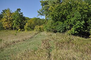
Buttrick's Creek Abandoned Segment
This 600 by 66 foot (183 by 20 m) section of old road was part of the original Lincoln Highway. It was left unused when a curve was straightened in 1920. This part of the road went past the farm of Capt. Albert Head. He was an early supporter of the highway and gave a lot of money to help build it.
The abandoned section now lies off County Road E53. It's on a grassy slope, and you can still clearly see the old road and its banks. This old road is not used for anything anymore.
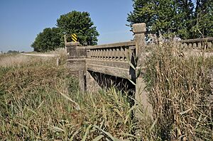
Little Beaver Creek Bridge
The bridge over Little Beaver Creek was built in 1915. It's made of reinforced concrete and has concrete railings. Today, it carries traffic on a gravel rural road over the creek. This road was part of the Lincoln Highway between 1914 and 1922.
The highway route was changed in this area. In 1920, people from Grand Junction asked for the route to be moved south. Both Greene and Boone County agreed. A new section of highway was built and finished in 1922. After that, this bridge and its road were given back to the local township.
Lincoln Statue
This statue of Abraham Lincoln in Jefferson is a copy of another statue in Cincinnati, Ohio. It was a gift from E.B. and Minnie Wilson. It was officially dedicated on September 22, 1918. This was the first statue of Lincoln built right next to, and dedicated to, the Lincoln Highway.
Historic Road Sections
Buttrick's Creek to Grand Junction Segment
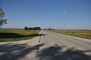
This is an original part of the old Lincoln Highway from 1913. Today, it's part of County Road E53. It stretches for 2.4 miles (3.9 km) across flat farmland. It goes from a curve east of Buttrick's Creek to Iowa Highway 144 near Grand Junction.
The Lincoln Highway in Iowa used to have many Y-shaped intersections. These have since been changed to T-intersections. A bend in this road was straightened in 1920. The whole stretch was paved with concrete in 1924. This historic area includes the road itself, its drainage system, and four culverts (small tunnels for water).
Grand Junction Segment
Most of this 1.75-mile (2.82 km) section of the Lincoln Highway was not on the original 1913 route. It was part of a deal with Boone County to move the highway south of the railroad tracks in 1920. This new path meant building a new road. It also got rid of all railroad crossings on this part of the highway. The new road was finished in 1922.
The western part of this road is in Grand Junction and was paved in 1923. The rural part to the east was paved the next year. Like the section above, it's now part of County Road E53. This historic area includes the urban and rural parts of the road, the West Beaver Creek Bridge, a culvert, and the road's drainage system. There's also a Lincoln Highway Marker in front of the Grand Junction city hall.
Raccoon River Rural Segment
This is another original section of the old Lincoln Highway from 1913. It's now part of County Road E53. It runs for 3.6 miles (5.8 km) through rolling farmland and the Raccoon River Valley. This historic area has 11 important features.
The road itself is broken into three parts. The first part is 1.4 miles (2.3 km) long and was paved in 1924. The second part is 1.3 miles (2.1 km) long and includes "Danger Hill." This hill was made less steep in 1920, and a sharp bend was replaced with a curve. This section was also paved in 1924. The third part is 0.9 miles (1.4 km) long. It was one of the first sections of the Lincoln Highway paved in Greene County in 1920.
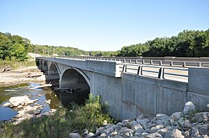
The Eureka Bridge is a large, five-arch concrete bridge. It's 422 feet (129 m) long. It replaced an older bridge that was partly washed away by a flood in 1912. This bridge is one of the earliest arch bridges still standing in Iowa. It was widened in 1924 because more cars were using it. Other historic features include the road's drainage system, six culverts, and a cattle pass. There's also a 600-foot (180 m) section of abandoned road at the top of Danger Hill.
West Beaver Creek Abandoned Segment
This abandoned section of road was part of the original Lincoln Highway from 1913. It lies north of the railroad tracks, near the Grand Junction Segment. The Lincoln Highway route was moved north in eastern Greene County in 1914. This helped connect the Greene and Boone County parts of the highway. It also removed some dangerous railroad crossings.
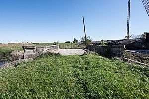
This section of road stayed part of the highway until 1922. That's when the road was moved south of the railroad tracks, and a new road was built. This change removed another railroad crossing at Grand Junction. This historic area has three important features: two structures and one site. One structure is an 18 by 24 foot (5.5 by 7.3 m) concrete bridge with concrete railings. It was built in 1915. The other structure is a partially buried concrete culvert. The site is a 0.1-mile (0.16 km) section of the old dirt road, which was never paved. This historic area is on a farm. The old road and bridge are still used to move farm machinery.
West Greene County Rural Segment
This is another original section of the old Lincoln Highway from 1913. The east-west part of this road is now County Road E39. The north-south part is now Iowa Highway 25. These roads are on fairly flat farmland. This historic area has 13 important features: 11 structures and two objects.
The structures include 4.35 miles (7.00 km) of roadway, the road's drainage system, eight culverts, and a special I-beam bridge. This section of the Lincoln Highway was paved in 1924. A new bridge was also built as part of this project. It replaced an older wooden bridge.
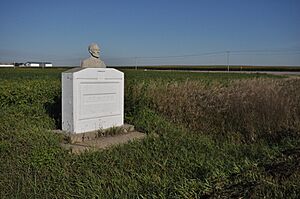
The two objects are special property markers. They are on private land where the road turns south from County Road E39 onto Iowa 25. These markers were placed there by James E. Moss. He farmed the land and was a big supporter of the Lincoln Highway. Moss was a veteran of the American Civil War. He had these identical markers put up in 1926. They were memorials to Abraham Lincoln, whom he called "one of our greatest citizens." They are concrete structures with a concrete bust (head and shoulders) of Abraham Lincoln on top. An "L" is stamped on the side, and "J.E. Moss" is stamped on the front.


