
Lincolnshire Wildlife Trust facts for kids

The Lincolnshire Wildlife Trust is a special group in Lincolnshire, England, that works to protect wild animals and plants, and their homes. It's part of a bigger family called the Wildlife Trusts partnership. This group started way back in 1948. Their main goal is to look after Lincolnshire's amazing wildlife and natural places. They also help people learn about and enjoy the natural world around them.
What the Trust Does
The main office for the Lincolnshire Wildlife Trust is in Horncastle, at a place called Banovallum House. The Trust has more than 27,000 members, which is a lot of people! They manage 95 different nature reserves across Lincolnshire. These reserves cover a huge area, about 34.49 square kilometers (or 8,523 acres).
Some of their most popular nature reserves, which are great for visitors and learning, include:
- Gibraltar Point National Nature Reserve This was the very first reserve the Trust bought in 1949. It's on the coast, about 5 kilometers (3 miles) south of Skegness. Here you can explore sand dunes, salt marsh, and even some brackish (slightly salty) pools. It has car parks and a visitors' centre with a cafe, shop, and toilets.
- Far Ings National Nature Reserve Opened in 1973, this reserve is in the north of the county, right by the Humber Estuary. It has beautiful lakes, reedbeds, and meadows. You can find car parking, toilets, a shop, and a classroom here.
- Whisby Nature Park This park opened in 1989 and is located near the A46 Lincoln by-pass. It features lakes, meadows, and young woodland. It's a fantastic place with car parking, an education centre (with a laboratory and classroom), and even an adventure playground for kids! There's also the 'Natural World Centre' with a cafe, shop, and cool exhibitions. (Just so you know, the car parks, playground, and 'Natural World Centre' are looked after by North Kesteven District Council).
- Snipe Dales Country Park & Nature Reserve This reserve opened in 1974 and is in the middle of the county. It has wet grassland, scrub, and some conifer (pine-like) woodland. The Trust is slowly replacing the conifer trees with native broadleaved trees. You'll find car parking and toilets here.
- Deeping Lakes Nature Reserve Opened in 2004, this reserve is in the south of Lincolnshire, next to the River Welland. It has lakes and young woodland. For now, only car parking is available as they continue to develop the site.
The Trust has 78 full-time and part-time staff members. But they also get a lot of help from over 1,300 volunteers! These volunteers often come from the Trust's 16 local groups, which are based in different towns across the county. These groups also arrange fun meetings, visits, and social events. They help with fundraising and finding new members too.
Did you know that about 5,000 of the Trust's members are under 16 years old? These younger members are part of a special group called Wildlife Watch. This group runs seven smaller clubs around the county, organizing exciting events just for children.
The Trust gets its money from different places. A lot comes from members paying their subscriptions, and from money raised by the local groups and other members. They also receive donations, grants from local councils and government groups (often for special projects), and money from sales in their shops. Sometimes, people even leave money to the Trust in their wills.
Nature Reserves and Special Places
The Lincolnshire Wildlife Trust looks after many different nature reserves. These places are important for protecting all sorts of wildlife, from tiny insects to large birds and mammals. Some reserves are open for everyone to visit, while others might need you to arrange a visit beforehand to protect sensitive habitats.
Here are a few examples of the types of places they manage:
- Ancaster Valley is known for its beautiful limestone grassland, full of wildflowers like pasqueflower and bee orchid. You might even spot birds like the Eurasian green woodpecker here.
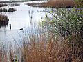
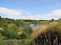
- Barrow Blow Wells features reedmarshes and woodland around natural springs called "blow wells."
- Barrow Haven Reedbed is another reedbed area, found in old, flooded clay pits.
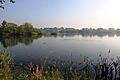
- Deeping Lakes is a wetland site with flooded gravel pits, perfect for wildfowl and other water birds.
- Donna Nook National Nature Reserve is a famous coastal salt marsh. It's especially known for its annual grey seal breeding season, where many seals come to have their pups.
- Far Ings National Nature Reserve (mentioned above) is a very important wetland site, recognized internationally for its reedbeds and wildfowl.
- Fiskerton Fen is another example of a fen habitat they protect.
- Gibraltar Point National Nature Reserve (mentioned above) is a key coastal reserve for birds and other wildlife.
- Saltfleetby – Threddlethorpe Dunes is a large coastal reserve with dunes, important for many species.
- Snipe Dales (mentioned above) offers a mix of wet grassland and woodland.
- Whisby Nature Park (mentioned above) is a popular spot with lakes and woodlands, great for family visits.
- Woodhall Spa Airfield Nature Reserve is a unique site on a former airfield and gravel quarry.
These are just a few of the many places the Trust works hard to protect, ensuring that Lincolnshire's natural beauty and wildlife can thrive for years to come.
Images for kids
-
Barrow Blow Wells Nature Reserve
-
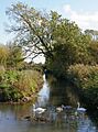
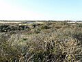
Barrow Haven Reedbed
-
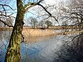
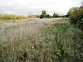
Baston Fen Nature Reserve
-
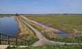
Dawson City Clay Pits Nature Reserve
-
Deeping Lakes Nature Reserve
-
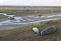
Grey seals at Donna Nook
-
Far Ings National Nature Reserve
-
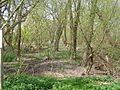
Fiskerton Fen Nature Reserve
-
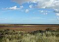
Frampton Marsh
-
Gibraltar Point National Nature Reserve
-
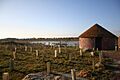
Great Casterton Road Banks
-
Saltfleetby – Threddlethorpe Dunes
-
Snipe Dales
-
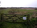
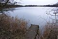
Stanton's Pit Nature Reserve
-
Whisby Nature Park
-
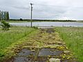
Woodhall Spa Airfield Nature Reserve


.jpg)
