Lingeigh facts for kids
| Meaning of name | heather island |
|---|---|
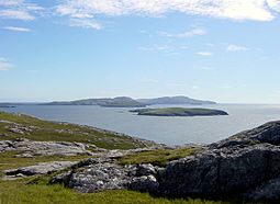
 Lingeigh from Vatersay. It is the small island behind the first small one. |
|
| OS grid reference | NL602896 |
| Coordinates | 56°52′12″N 7°34′48″W / 56.87°N 7.580°W |
| Physical geography | |
| Island group | Uists and Barra |
| Area | 27 ha (0.10 sq mi) |
| Highest elevation | 83 m (272 ft) |
| Administration | |
| Sovereign state | United Kingdom |
| Country | Scotland |
| Council area | Na h-Eileanan Siar |
| Demographics | |
| Population | 0 |
Lingeigh (also spelled Lingay) is a small, empty island located in the Outer Hebrides of Scotland. It's a peaceful place with no people living on it. This little island is part of a chain of islands that stretch along the northwest coast of Scotland.
Contents
Discovering Lingeigh: A Scottish Islet
Lingeigh is a fascinating, uninhabited islet. It's known for its quiet beauty and natural features. Even though no one lives there, it plays a small part in the amazing landscape of the Outer Hebrides.
Where is Lingeigh Located?
Lingeigh is found in the southern part of the Outer Hebrides. It sits just north of another island called Pabbay. It's also about 5 kilometers (3 miles) south of Vatersay, which is a larger island. These islands are part of the Uists and Barra island group. The local government for this area is Na h-Eileanan Siar.
What Does Lingeigh Look Like?
Lingeigh is quite small, covering an area of about 27 hectares (which is about 67 acres). Its highest point reaches 83 meters (272 feet) above sea level. One cool feature of Lingeigh is a cave found on its southeast side. Imagine exploring a hidden cave on a quiet island! The island's name, "Lingeigh," actually means "heather island." This suggests that the island might have a lot of heather plants growing on it, which are beautiful purple flowers common in Scotland.
Why is Lingeigh Uninhabited?
Like many small islands in the Outer Hebrides, Lingeigh is uninhabited. This means it has no permanent residents. Small islands often lack fresh water, good soil for farming, or safe harbors. These things make it hard for people to live there all the time. However, these islands are often important for wildlife, like seabirds.
 | William L. Dawson |
 | W. E. B. Du Bois |
 | Harry Belafonte |

