
List of National Natural Landmarks in Texas facts for kids
Texas is a big state with many amazing natural places! Some of these special spots are called National Natural Landmarks. These landmarks are chosen because they show off the best examples of America's natural history. They might have unique plants, animals, rocks, or landforms that are super important for science and for us to learn about. There are 21 of these cool landmarks in Texas, and each one tells a story about our planet's past and present.
Contents
Incredible Natural Wonders of Texas
Texas is home to many incredible natural landmarks. These places are protected because they show off unique parts of our planet's history and nature. Let's explore some of them!
Amazing Caves and Sinkholes
Texas has some fantastic underground worlds!
Caverns of Sonora

The Caverns of Sonora are famous for their incredibly beautiful and unusual cave formations. You can see delicate, blade-like shapes called helictites and coral-like growths. It's like an art gallery created by nature! This landmark was recognized in 1965.
Devil's Sinkhole
Devil's Sinkhole is a giant, bell-shaped hole in the ground. It formed when limestone rock collapsed. This deep sinkhole is a special home for many bats. It became a landmark in 1972.
Ezell's Cave
Ezell's Cave is a very important cave because it's home to at least 36 different kinds of cave animals. Many of these animals live only in caves and nowhere else! It was named a landmark in 1971.
Longhorn Cavern

Longhorn Cavern is a state park that shows off amazing cave features. These features were formed when the cave was completely filled with water a long, long time ago. It became a landmark in 1971.
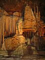
Natural Bridge Caverns

Natural Bridge Caverns is a huge cave system with many levels. It has unusual rock formations called speleothems and intricate helictites, similar to those in Caverns of Sonora. This landmark was recognized in 1971.
Cave Without a Name

The Cave Without a Name has some of the rarest and most amazing speleothems in the country. These formations are truly special and beautiful. It was added to the list of landmarks in 2009.
Dinosaur Footprints and Meteor Craters
Imagine walking where dinosaurs once roamed or seeing where a space rock hit Earth!
Dinosaur Valley State Park

Dinosaur Valley State Park is super cool because it's the only place where you can see clear, full-sized footprints of giant plant-eating dinosaurs called sauropods. It's like a prehistoric sidewalk! This park became a landmark in 1968.
Odessa Meteor Crater

The Odessa Meteor Crater is a site with two craters made by meteorites hitting Earth. The biggest crater is about 550 feet (168 meters) wide! It's a great place to learn about space impacts. It was recognized in 1965.
Unique Rock Formations and Canyons
Texas has some stunning landscapes carved by nature.
Enchanted Rock

Enchanted Rock is a giant, rounded granite dome. It's a perfect example of a batholith, which is a huge mass of igneous rock that formed deep underground. You can also see how layers of rock peel off like an onion, a process called exfoliation. It became a landmark in 1971.
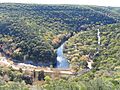
Palo Duro Canyon State Park

Palo Duro Canyon State Park features a spectacular canyon. It's an amazing example of how running water can carve out huge landforms over millions of years. It's often called the "Grand Canyon of Texas." This landmark was recognized in 1976.
Wildlife and Natural Habitats
Many landmarks protect important homes for plants and animals.
Attwater Prairie Chicken Preserve

The Attwater Prairie Chicken Preserve protects one of the last remaining parts of the Gulf Coastal Prairie. This special grassland is home to the endangered Attwater's prairie chicken. It was named a landmark in 1968.
Bayside Resaca Area
The Bayside Resaca Area is part of the Laguna Atascosa National Wildlife Refuge. It has a great example of a resaca, which is an old, dried-up river channel that now holds water and supports wildlife. It became a landmark in 1980.
Fort Worth Nature Center and Refuge
The Fort Worth Nature Center and Refuge has excellent examples of the unique oak-hickory forests known as "cross timbers." These forests are important habitats for many animals. It was recognized in 1980.
High Plains Natural Area

The High Plains Natural Area is one of the best examples of natural shortgrass prairie left in the Great Plains. This type of grassland is very important for many species. It became a landmark in 1980.
Lost Maples State Natural Area

Lost Maples State Natural Area is a wonderful place to see the plants and animals of the Edwards Plateau. It's especially famous for its bigtooth maples, which put on a beautiful fall color show. This area was recognized in 1980.
Muleshoe National Wildlife Refuge

Muleshoe National Wildlife Refuge protects saline lake beds and shortgrass grasslands. These areas are typical of the high plains and provide important homes for many birds, including sandhill cranes. It became a landmark in 1980.
Santa Ana National Wildlife Refuge

The Santa Ana National Wildlife Refuge is like a living museum of the lowland forests in the Lower Rio Grande Valley. It's a critical spot for many bird species and other wildlife. It was named a landmark in 1966.
Other Important Natural Sites
Greenwood Canyon
Greenwood Canyon is a very important place for scientists because it's full of early Cretaceous mammalian fossils. These fossils help us understand ancient mammals. It was recognized in 1975.
Images for kids
-
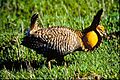
An Attwater's Prairie Chicken.
-
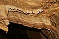
Unusual formations inside the Caverns of Sonora.
-
Dinosaur footprints preserved at Dinosaur Valley State Park.
-
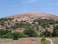
The massive granite dome of Enchanted Rock.
-
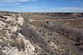
Buffalo Lake National Wildlife Refuge, part of the High Plains Natural Area.
-

The entrance to Longhorn Cavern.
-
Beautiful fall colors at Lost Maples State Natural Area.
-
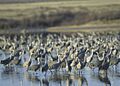
Sandhill cranes at Muleshoe National Wildlife Refuge.
-
The Odessa Meteor Crater.
-
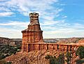
The "Lighthouse" formation in Palo Duro Canyon.
-
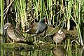
Wildlife at Santa Ana National Wildlife Refuge.
-

Inside Natural Bridge Caverns, showing unique formations.
-
Beautiful speleothems inside Cave Without a Name.
See also
