
Lost Maples State Natural Area facts for kids
Quick facts for kids Lost Maples State Natural Area |
|
|---|---|

Lost Maples State Natural Area
Location in Texas
|
|
| Location | Bandera County / Real County, Texas |
| Nearest city | Vanderpool |
| Area | 2,906 acres (11.76 km2) |
| Established | 1979 |
| Governing body | Texas Parks and Wildlife Department |
| Designated: | 1980 |


Lost Maples State Natural Area is a beautiful place in Texas. It has amazing hills, deep canyons, and a clear river called the Sabinal River. It's located in the Edwards Plateau region.
This area is called a Natural Area instead of a State Park. This means its main goal is to protect nature. So, some activities might be limited to keep the area safe and wild. The Texas Parks & Wildlife Department (TPWD) makes sure the environment is protected.
Contents
Where is Lost Maples Located?
Lost Maples State Natural Area covers about 2,906 acres (11.76 square kilometers). It is about 5 miles (8 kilometers) north of Vanderpool, Texas. It's also about 71 miles (114 kilometers) northwest of San Antonio. The area is found in western Bandera County and eastern Real County.
History of Lost Maples
The state of Texas bought the land for Lost Maples in 1973 and 1974. It first opened to the public in 1979. In 1980, it became a National Natural Landmark. This means it's a very special natural place in the United States.
People have lived in this area for a very long time, even before recorded history. Spanish explorers arrived in the 1600s. They found different Indian groups living here. These groups included the Apache, Lipan Apache, and Comanche people. They hunted and gathered food in this part of the Texas Hill Country.
Amazing Animals (Fauna)
Many different animals live at Lost Maples. White-tailed deer are very common here. You might also see wild turkeys, armadillos, skunks, raccoons, opossums, and rabbits. Fox squirrels are also present.
Sometimes, visitors might spot wild pigs or axis deer. Porcupines, rock squirrels, and ringtails also live here. Bobcats, coyotes, and foxes are in the area. Very rarely, you might even see a mountain lion.
Many different kinds of birds live here all year. This includes several types of raptors, like hawks and owls. Be careful of venomous snakes like the copperhead and coral. The Sabinal River always has water, even during dry times. So, fish and other water animals are always present.
Wonderful Plants (Flora)
Lost Maples is home to many plants. You'll see Ashe juniper trees, often called mountain cedar. There are also many types of oak trees. The most famous trees are the bigtooth maples. These maples give the area its name.
Other trees include sycamore, mesquite, Texas persimmon, and Texas mountain-laurel. You can also find Texas madrone, redbud, and wild grape. Prickly pear cacti are also common.
The bigtooth maples turn amazing colors in the fall. Their leaves are brightest if autumn is dry or has cold nights. If it's a mild, damp autumn, the colors might not be as bright. Texas red oaks also turn a beautiful crimson color almost every year. They can keep their leaves well into winter.
The Natural Area is most popular in late October and early November. This is when the fall colors are at their best. Scientists believe the maple trees here are "relics." This means they are leftovers from a time when maples grew more widely. That was during a cooler and wetter climate, like the last glacial period. Today, these maples only grow in special soils and climates.
You can find a longer list of all the animals and plants at the LMSNA Ranger Station.
Fun Things to Do (Recreation)
Lost Maples is a State Natural Area. This means it's set up to let visitors explore while still protecting nature. The reserve has about 11 miles (18 kilometers) of hiking trails. There are also 30 campsites and eight simple camping areas. In the middle of the park, you'll find two small lakes along Can Creek.
The Texas Parks & Wildlife Department wants all visitors to follow the Leave No Trace rules. These rules help protect the park:
- Plan Ahead and Prepare for your trip.
- Always stay on marked trails.
- Always dispose of your trash properly.
- Leave behind anything you find, like rocks or plants.
- Never build an open fire.
- Respect all wildlife.
- Be considerate of other visitors.
Please follow these rules to help protect the park's special natural and cultural resources!
- Lost Maples State Natural Area from the Handbook of Texas Online
Images for kids
-
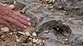
A Texas brown tarantula
-
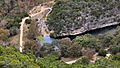
One of the ponds in Can Creek Canyon, seen from an East Trail overlook


