
List of Pennsylvania state historical markers in Montgomery County facts for kids

Welcome to Montgomery County, Pennsylvania! This area is full of history, and you can find special signs called state historical markers all around. These markers are like outdoor history books, telling stories about important people, places, and events that happened right here. The Pennsylvania Historical and Museum Commission (PHMC) puts them up to help everyone learn about Pennsylvania's past. There are 60 of these cool markers in Montgomery County, each sharing a piece of history. Let's explore some of them!
Contents
Revolutionary War Stories
Montgomery County played a big part in the American Revolution. Many markers tell us about the brave people and key moments from that time.
Heroes of the Revolution
- Edward Hector: Edward Hector was an African American hero who drove a wagon for the Continental Army during the Revolutionary War. He bravely saved his wagon and horses, even when others abandoned theirs. His marker is in Conshohocken.
- Gen. Andrew Porter: General Andrew Porter was a soldier who fought in the Revolutionary War. He was also a surveyor and later served in government. His marker is in Norristown.
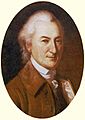
- Timothy Matlack: Timothy Matlack was an important figure during the Revolution. He was a scribe who wrote out the official copy of the Declaration of Independence. His marker is in Audubon.
Battles and Camps
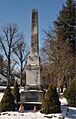
- Crooked Billet: This marker tells about a battle that happened in May 1778, during the Revolutionary War. American forces fought against British soldiers here. You can find this marker in Hatboro.
- Gulph Mills Encampment: After the famous Valley Forge encampment, General George Washington and his army camped at Gulph Mills in December 1777. This marker reminds us of their difficult winter.
- Whitemarsh: This area was the site of another important encampment for George Washington's army in late 1777. The marker highlights the strategic importance of this location during the war.
Important People and Their Legacies
Many famous and influential people lived or worked in Montgomery County. Their stories are told through these markers.
Leaders and Thinkers
- Frederick A. C. Muhlenberg (1750-1801): Frederick Muhlenberg was a very important person in early American history. He was the first Speaker of the U.S. House of Representatives. His marker is in Trappe.
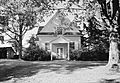
- John Dickinson: Known as the "Penman of the Revolution," John Dickinson was a lawyer and politician who helped write important documents like the Articles of Confederation. His marker is in Merion.
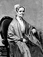
- Lucretia C. Mott: Lucretia Mott was a powerful voice for women's rights and the abolition of slavery in the 1800s. She was a Quaker minister and a leader in social reform. Her marker is in Elkins Park.
- Woodrow Wilson: Before becoming the 28th President of the United States, Woodrow Wilson taught at Bryn Mawr College in Montgomery County. His marker is in Bryn Mawr.
Innovators and Creators
- Cyrus H. K. Curtis (1850-1933): Cyrus Curtis was a publishing giant who founded the Curtis Publishing Company. He published popular magazines like The Saturday Evening Post and Ladies' Home Journal. His marker is in Wyncote.
- Harold F. Pitcairn: Harold Pitcairn was a pioneer in aviation. He developed the autogiro, an early type of aircraft that was a step towards modern helicopters. His marker is in Bryn Athyn.
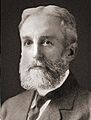
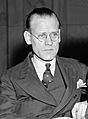
- Philo T. Farnsworth (1906-1971): Philo Farnsworth was an inventor who played a key role in developing the electronic television. His groundbreaking work changed how people received information and entertainment. His marker is in Wyndmoor.
- William B. T. Trego (1858-1909): William Trego was a talented artist known for his historical and military paintings. His marker is in North Wales.
Sports and Entertainment
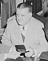
- Bert Bell: Bert Bell was a famous figure in American football. He was a player, coach, and later the commissioner of the NFL. His marker is in Narberth.
- James A. Bland: James Bland was a gifted African American musician and songwriter. He wrote over 700 songs, including "Carry Me Back to Old Virginny." His marker is in Bala Cynwyd.
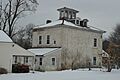
- Betzwood Motion Picture Studio: This marker celebrates an early movie studio that operated in Norristown. It was an important place for filmmaking in the early 1900s.
Historic Buildings and Places
Montgomery County is home to many beautiful and historically significant buildings, from churches to homes.
Churches and Meeting Houses
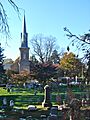
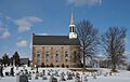
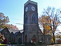
- Abington Presbyterian Church: This church has a long history, dating back to the early 1700s. It's a significant religious site in the area. Its marker is in Abington.
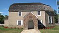
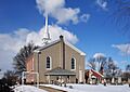
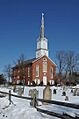
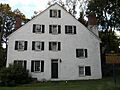
- Augustus Lutheran Church: Built in 1743, this is one of the oldest Lutheran churches in America. Its marker is in Trappe.
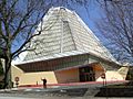
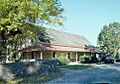
- Beth Sholom Synagogue: This unique synagogue was designed by the famous architect Frank Lloyd Wright. It's a stunning example of modern architecture. Its marker is in Elkins Park.
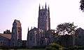
- Bryn Athyn Cathedral: This beautiful cathedral is known for its unique architecture and craftsmanship. It was built in the early 20th century. Its marker is in Bryn Athyn.
- Merion Friends Meeting: This historic Quaker meeting house was built in 1695, making it one of the oldest places of worship in Pennsylvania. Its marker is in Narberth.
Homes and Mansions
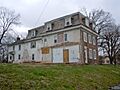
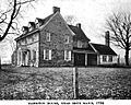
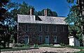
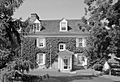
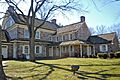
- Harriton: This historic home was built in 1704 and was once owned by Charles Thomson, a key figure in the American Revolution. Its marker is near Bryn Mawr.
- Hope Lodge: A beautiful 18th-century country estate, Hope Lodge served as a headquarters for American forces during the Revolutionary War. Its marker is in Fort Washington.
- Mill Grove: This was the first home in America for the famous artist and naturalist John James Audubon. He studied birds here and began his famous work, The Birds of America. Its marker is in Audubon.
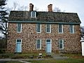
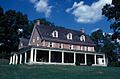
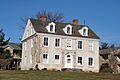
- Pottsgrove Manor: Built in 1752, this grand Georgian mansion was the home of John Potts, an ironmaster and founder of Pottstown. Its marker is in Pottstown.
Other Notable Sites
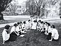
- Bryn Mawr Summer School for Women Workers in Industry: This school, active from 1921 to 1938, offered education to women working in factories. It was a pioneering effort for workers' rights and education. Its marker is in Bryn Mawr.
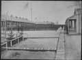
- Camp William Penn: During the Civil War, Camp William Penn was the largest training camp for African American soldiers in the United States. Many brave soldiers trained here before fighting for the Union. Its marker is in LaMott.
- Pennsylvania School of Horticulture for Women, The: This school, founded in 1910, provided women with education in farming and gardening, a field usually dominated by men. Its marker is in Ambler.
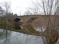
- Perkiomen Bridge: This stone arch bridge, built in 1799, is a historic landmark. It's one of the oldest bridges in Pennsylvania still in use. Its marker is in Collegeville.
Images for kids
-
Abington Presbyterian Church
-
Augustus Lutheran Church
-
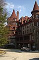
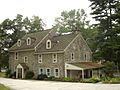
Baldwin School
-
Bert Bell
-
Beth Sholom Synagogue
-
Bryn Athyn Cathedral
-
Bryn Mawr Summer School for Women Workers in Industry
-
Camp William Penn
-
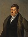
Charles Thomson
-
Crooked Billet Monument
-
Cyrus H. K. Curtis
-
General Wayne Inn
-
Falkner Swamp Reformed Church
-
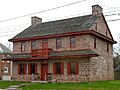
Frederick A. C. Muhlenberg House
-
Graeme Park
-
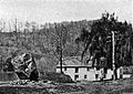
Gulph Mills Village
-
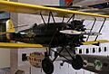
Harold F. Pitcairn's Autogiro
-
Harriton House
-
Hope Lodge
-
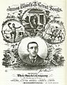
James A. Bland
-
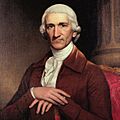
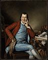
John Dickinson
-
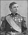
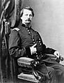
John F. Hartranft
-
Keith House
-
Marquis de Lafayette
-
Lucretia C. Mott
-
Merion Friends Meeting House
-
Mill Grove
-
Muhlenberg Home
-
Muhlenberg House
-
New Goschenhoppen Reformed Church
-
New Hanover Lutheran Church
-
Pennsylvania School of Horticulture for Women
-
Pennypacker's Mill and Mansion
-
Perkiomen Bridge
-
Philo T. Farnsworth
-
Plymouth Friends Meetinghouse
-
Pottsgrove Manor
-
Selma Mansion
-
St. Paul's Episcopal Church
-
Thomas Rowland & Sons Shovel Works
-
Timothy Matlack
-
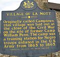
Village of La Mott
-
Wall House (The Ivy)
-
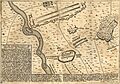
Battle of Whitemarsh map
-
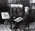
William B. T. Trego's studio
-
Winfield S. Hancock
-
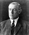
Woodrow Wilson


.jpg)


.jpg)


,_Merion_Station_(Montgomery_County,_Pennsylvania).jpg)
.jpg)


.JPG)


See also
- List of Pennsylvania state historical markers
- National Register of Historic Places listings in Montgomery County, Pennsylvania
