
List of prehistoric scheduled monuments in north Pembrokeshire facts for kids
Pembrokeshire is a county in Wales that's full of amazing ancient sites! These special places are called scheduled monuments, and they are protected by law because they are so important to history. Pembrokeshire has more of these ancient sites than almost any other county in Wales, with over 500 in total. That means there are lots of cool historical spots to explore!
Most of these protected sites, about two-thirds, are from prehistoric times. This means they were built long, long ago, before people started writing things down. Because there are so many, they are often split into different lists. This article will focus on the 233 prehistoric sites found in the northern part of Pembrokeshire.
These ancient sites include many different types of structures built by people thousands of years ago. You'll find hill forts and promontory forts (which are like forts on high cliffs or hillsides), as well as various enclosures and hut sites where people lived. There are also many burial sites like barrows (mounds of earth) and chambered tombs (stone burial rooms). Plus, there are mysterious stone circles and standing stones that might have been used for ceremonies or as markers.
These important sites are looked after by Cadw, a Welsh government agency that protects historic places. They work with other groups like RCAHMW and Dyfed Archaeological Trust to keep track of these treasures.
Contents
- Prehistoric Wonders in North Pembrokeshire
- Ancient Burial Chambers
- Parc-y-Llyn Burial Chamber
- Tre-Ffynnon Burial Chamber
- Burton Burial Chamber
- Bedd yr Afanc Burial Chamber
- Garn Wen Burial Chambers
- Pen-Rhiw Burial Chamber
- Carreg Samson Dolmen
- Llech-y-Tribedd Burial Chamber
- Pentre Ifan Dolmen
- Carreg Coetan Arthur Burial Chamber
- Cerig-y-Gof Burial Chamber
- Trefflys Burial Chamber
- Colston Burial Chamber
- Carn Llidi Burial Chambers
- Coetan Arthur Burial Chamber
- Standing Stones and Stone Circles
- Hillforts and Promontory Forts
- Brawdy Promontory Fort
- Keeston Castle
- Castell Pengegin
- Dinas Island Castell
- Carn Alw Hillfort
- Castell Mawr
- St Lawrence Camp
- South Hook Camp
- Castell Coch Promontory Fort
- Deer Park Promontory Fort
- Castell Coch Promontory Fort (on Penmorfa)
- Ynys y Castell
- Castell Henllys
- Castell Tre-Riffith
- Pen-Castell Promontory Fort
- Carn Ffoi Camp
- Carn Ingli Camp
- Slade Camp
- Dinas Mawr Camp
- Garn Fawr Camp
- Summerton Camp
- Castle Lake Camp
- Porth-y-Rhaw Camp
- Caerfai Camp
- Clegyr Boia Camp
- St David's Head Camp
- Promontory Fort on Great Castle Head
- Black Point Rath
- Waun-Castell Camp
- Capeston Rath
- Lamborough Camp
- Great Treffgarne Rocks Camp
- Other Interesting Sites
- Ancient Burial Chambers
- Images for kids
- See also
Prehistoric Wonders in North Pembrokeshire
North Pembrokeshire is home to many fascinating prehistoric monuments. Let's take a closer look at some of them.
Ancient Burial Chambers
Chambered tombs are ancient burial places made of large stones. They often look like stone rooms or chambers.
Parc-y-Llyn Burial Chamber

This site in Ambleston features a large capstone (a flat stone forming a roof) resting on four smaller upright stones. It was first recorded in 1871.
Tre-Ffynnon Burial Chamber
In Brawdy, east of Trefynnon, you can find this chambered tomb. It has three upright stones supporting a 2-meter capstone. The chamber is now filled with stones from nearby fields.
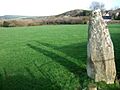
Burton Burial Chamber
_-_geograph.org.uk_-_1025366.jpg)
Also known as The Hanging Stone, this tomb in Burton has three upright stones holding up a large, tall capstone.
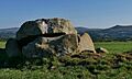
Bedd yr Afanc Burial Chamber

Located in Eglwyswrw, this is a passage grave within a long mound, about 15 meters long. Seven stones form a P-shaped burial chamber. It was explored in 1939.
Garn Wen Burial Chambers

Near Fishguard and Goodwick, you'll find a line of at least three, possibly four, cromlechs (another name for a type of chambered tomb). They are partly hidden by plants on a hillside above the Fishguard Ferry Terminal.
Pen-Rhiw Burial Chamber

This broad, low-lying cromlech is in a grassy field north of Pen-rhiw farm, also near Fishguard and Goodwick.
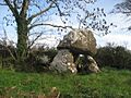
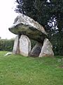
Carreg Samson Dolmen

In Mathry, this impressive dolmen has a huge capstone supported by three of its six surrounding upright stones. While traditionally thought of as a tomb, some recent studies suggest it was designed to show off the elevated capstone, and might not have been covered by a mound.
Llech-y-Tribedd Burial Chamber

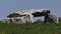
This well-preserved dolmen in Nevern has three tall, tapering upright stones and a massive capstone.
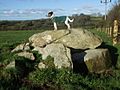
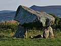
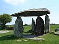
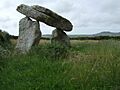
Pentre Ifan Dolmen

![]() Also in Nevern, this is one of the most famous ancient sites in Wales. It has a 16-tonne capstone supported 2.5 meters off the ground by three slender upright stones. It was given legal protection in 1882. Like Carreg Samson, some experts now think it was built to display the capstone, not to be covered by a mound.
Also in Nevern, this is one of the most famous ancient sites in Wales. It has a 16-tonne capstone supported 2.5 meters off the ground by three slender upright stones. It was given legal protection in 1882. Like Carreg Samson, some experts now think it was built to display the capstone, not to be covered by a mound.
Carreg Coetan Arthur Burial Chamber

![]() This large, well-preserved dolmen is found among houses in Newport. It was excavated in 1979–80.
This large, well-preserved dolmen is found among houses in Newport. It was excavated in 1979–80.
Cerig-y-Gof Burial Chamber

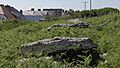
In Newport, this site has a group of up to five stone-lined chambers. It's believed they were once under a single mound, and each had its own entrance. One still has a large capstone.
Trefflys Burial Chamber

Also known as Ffyst Samson, this dolmen in Pencaer has two strong upright stones, about 2 meters apart, supporting a large capstone that slopes down to the north.
Colston Burial Chamber
In Puncheston, this chamber is also called 'The Altar'. It's a stone chamber with a capstone built into a field boundary. Another chamber next to it was destroyed around 1815 when a road was built.
Carn Llidi Burial Chambers
In St Davids and the Cathedral Close, you can find these burial chambers near Carn Llidi.
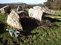
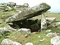
Coetan Arthur Burial Chamber

This chambered tomb is located near St David's Head in St Davids and the Cathedral Close.
Standing Stones and Stone Circles
Standing stones are tall, upright stones, sometimes arranged in rows or circles. They were often used for ceremonies or as markers.
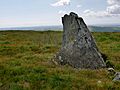
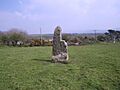
Bedd Morris Standing Stone

This standing stone in Cwm Gwaun was damaged in 2011, probably by a vehicle. An excavation showed it had been there since the Bronze Age. It was repaired and put back in its original spot in 2012.
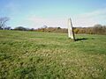
Cerrig Lladron stone row

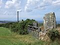
Also in Cwm Gwaun, this site has three standing stones, though one has fallen. They line up with the nearby Foel Eryr hilltop cairn.
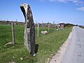
Parc-y-Meirw Standing Stones

This impressive row of four large standing stones is in Cwm Gwaun. At least two other stones are now lying down. It might also line up with the Trellwyn Fawr stone.
Trellwyn Fach, Standing Stone

This 2-meter tall standing stone, also known as Parc Maenhir, is in Cwm Gwaun.
Parc Cerric Hirion

In Dinas Cross, this 2.1-meter tall standing stone leans quite a bit. It's sometimes confused with The Lady Stone nearby.
The Lady Stone, Ty-Meini

This tall, tapering 2.7-meter standing stone is near a road in Dinas Cross. Its rounded top is said to look like a heavily veiled lady.
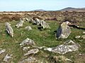
Dyffryn Stone Circle
In Puncheston, you can find the Dyffryn Stone Circle, a prehistoric arrangement of stones.
Hillforts and Promontory Forts
Hillforts are ancient forts built on hills, while promontory forts are similar but built on high pieces of land that stick out, often into the sea or a river.
Brawdy Promontory Fort
This inland promontory fort is located in Brawdy.
Keeston Castle
In Camrose, Keeston Castle is an example of a hillfort.
Castell Pengegin
This inland promontory fort is found in Cwm Gwaun.
Dinas Island Castell
An inland promontory fort located in Dinas Cross.
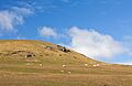
Carn Alw Hillfort
This hillfort is situated in Eglwyswrw.
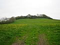
Castell Mawr

Another hillfort in Eglwyswrw.
St Lawrence Camp
An inland promontory fort located in Hayscastle.
South Hook Camp
This coastal promontory fort is in Herbrandston.
Castell Coch Promontory Fort
An inland promontory fort in Llanrhian.
Deer Park Promontory Fort
A coastal promontory fort in Marloes and St Brides.
Castell Coch Promontory Fort (on Penmorfa)

This coastal promontory fort is located in Mathry.
Ynys y Castell
A hillfort found in Mathry.
Castell Henllys
This hillfort in Nevern is a well-known site.
Castell Tre-Riffith
A coastal promontory fort in Nevern.
Pen-Castell Promontory Fort
Another coastal promontory fort in Nevern.
Carn Ffoi Camp
A hillfort located in Newport.
Carn Ingli Camp
Carn Ingli is a hillfort in Newport.
Slade Camp
An inland promontory fort in Nolton and Roch.
Dinas Mawr Camp

A coastal promontory fort in Pencaer.
Garn Fawr Camp
A hillfort in Pencaer.
Summerton Camp
A hillfort located in Puncheston.
Castle Lake Camp
A coastal promontory fort in Slebech.
Porth-y-Rhaw Camp

A coastal promontory fort in Solva.
Caerfai Camp

A coastal promontory fort in St Davids and the Cathedral Close.
Clegyr Boia Camp

A hillfort in St Davids and the Cathedral Close.
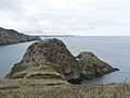
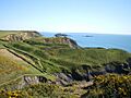
St David's Head Camp
A coastal promontory fort at St David's Head.
Promontory Fort on Great Castle Head
A coastal promontory fort in St Ishmael's.
Black Point Rath
A coastal promontory fort in The Havens.
Waun-Castell Camp
An inland promontory fort in Trecwn.
Capeston Rath
An inland promontory fort in Walwyn's Castle.
Lamborough Camp
An inland promontory fort in Wiston.
Great Treffgarne Rocks Camp
A hillfort in Wolfscastle.
Other Interesting Sites
There are many other types of prehistoric sites in North Pembrokeshire, including:
- Enclosures: Fenced-off areas, sometimes for defense.
- Raths or Ringforts: Circular forts or settlements.
- Round barrows and Round cairns: Mounds of earth or stones used for burials.
- Hut circles and Hut circle settlements: Remains of ancient homes.
- Burnt mounds: Piles of heat-cracked stones, often from ancient cooking sites.
Banc Du Neolithic Enclosure

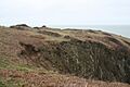
In Puncheston, this is the first confirmed Neolithic enclosure in Wales. Digs in 2012 showed it had ramparts (defensive walls) made with stone and timber posts. It dates back to about 3650 BC!
Rudbaxton Rath

This rath (a type of circular fort or settlement) is located in Rudbaxton.
Rath S of St James Church

Another rath, found south of St James Church in Walwyn's Castle.
Images for kids
-
Parc-y-Llyn burial chamber
-
The Hanging Stone, Burton
-
Bedd Morris standing stone, before the 2011 damage
-
Cerrig Lladron standing stone
-
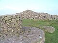
Summit cairn on Foel Eryr
-
Parc y Meirw megalithic alignment
-
Trellwyn-fach maenhir
-
Standing Stone leaning at Dinas Cross
-
The Lady Stone near Dinas Cross
-
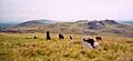
Bedd Arthur stone oval, Preseli Mountains
-
Bedd yr Afanc, looking east-southeast
-
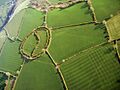
Castell Mawr from the air
-
Garn Wen Cromlechs
-
Pen Rhiw Cromlech
-

Carreg Samson Dolmen
-
Castell Coch, Penmorfa
-
Llech-y-Tribedd Burial Chamber
-
Pentre Ifan Dolman
-
Trellyffant Dolman
-
Carreg Coetan burial chamber
-
Cerrig y Gof chambered tomb
-
Dinas Mawr promontary fort
-
Ffyst Samson dolmen
-
Banc Du hillside
-
The Rath, Rudbaxton
-
Porth y Rhaw hillfort from the west
-
Coetan Arthur Burial Chamber, St David's Head
-
Caerfaihillfort on Penpleidiau
-
Clegyr Boia, view east
-
Rath (Ringwork) at Walwyn's Castle


See also
