
Ambleston facts for kids
Quick facts for kids Ambleston
|
|
|---|---|
 |
|

Ambleston
|
|
| Population | 382 (2011) |
| OS grid reference | SN000257 |
| Principal area | |
| Country | Wales |
| Sovereign state | United Kingdom |
| Post town | HAVERFORDWEST |
| Postcode district | SA62 |
| Post town | CLARBESTON ROAD |
| Postcode district | SA63 |
| Police | Dyfed-Powys |
| Fire | Mid and West Wales |
| Ambulance | Welsh |
| EU Parliament | Wales |
| UK Parliament |
|
| Welsh Assembly |
|
Ambleston, known as Treamlod in Welsh, is a small village in Pembrokeshire, Wales. It's about 11 kilometers (7 miles) northeast of Haverfordwest. The area around Ambleston also includes the small villages of Wallis and Woodstock.
Contents
What's in a Name?
The name Ambleston comes from an old meaning: "Amlot's farm." Amlot was a name used by people from Normandy, France, who came to Britain a long time ago.
Where is Ambleston and Who Lives There?
The northern edge of Ambleston parish follows an old path. This path leads towards St David's. It also goes through an old Roman farm called "Castell Fflemish."
This boundary was once very important. In 1602, a writer named George Owen called it a "language frontier." This meant it was where the Welsh language met the English language. Ambleston was in an area known as "Little England beyond Wales." This name was given because English was spoken more there.
Ambleston was one of the places Owen said had people who spoke both languages. In more recent times, many people in Ambleston spoke Welsh. In 2011, about 34.3% of people in Ambleston could speak Welsh. This was a bit less than in 2001. In the past, even more people spoke Welsh. For example, in 1891, about 86% of people spoke Welsh.
The number of people living in Ambleston has changed over time. In 2001, there were 367 people. By 2011, the population grew slightly to 382 people.
How Ambleston is Governed
Ambleston works with two other communities, Spittal and Wiston. Together, they form an area called the Wiston electoral ward in Pembrokeshire. This ward helps choose local representatives.
Discovering Ambleston's Past
Ambleston is home to some very old and interesting sites. These places tell us about people who lived here long ago.
Castle Flemish: A Roman Farm
About a kilometer north of Ambleston village, there's a special spot called Castle Flemish. It's a low, four-sided bank that encloses an area about 80 meters wide. For a long time, people thought this site was related to the Roman army.
In 1922, an archaeologist named Mortimer Wheeler dug at the site. He found Roman bricks, tiles, and pottery. These discoveries showed that Castle Flemish was likely a Roman farmstead or a small Roman villa. It probably had a bathhouse and living areas. This farm was likely built in the late 1st century. There were old stories about a "golden table" found here, but these stories have not been proven. Today, Castle Flemish is a Scheduled ancient monument. This means it's a protected historical site.
Parc-y-Llyn Burial Chamber: An Ancient Tomb
Another ancient site in Ambleston is the Parc-y-Llyn Burial Chamber. This is a large stone structure that might be a Neolithic chambered tomb. It has a big capstone, which is a large flat stone, about 2 meters across. This capstone rests on four smaller upright stones.
This site was first noticed in 1871 and became a protected monument in 1938. If it is a Neolithic tomb, it would be extremely old, dating back to between 4400 and 2900 BC. However, because no other ancient items have been found there, some people wonder if it's truly from the Neolithic period.
A map from 1578, kept in the British Library, shows the parish of Ambleston as it was back then.
Images for kids
-
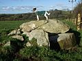
Parc-y-Llyn burial chamber, an ancient stone structure.

