
List of sites on the Queensland Heritage Register in Warwick facts for kids
Warwick, a town in Queensland, Australia, is home to many special places listed on the Queensland Heritage Register. This register is like a very important list that helps protect buildings, sites, and objects that tell us about Queensland's history and culture. These places are important because they show us how people lived, worked, and built their communities a long time ago. Exploring these heritage sites in Warwick is like taking a trip back in time!
Contents
Historic Buildings in Warwick
Warwick has many old and beautiful buildings that are important parts of its history.
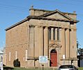
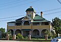
St Mark's Anglican Church

Located on Albion Street, St Mark's Anglican Church is a stunning example of old church architecture. It was built in the 1870s and has been a central part of the Warwick community for over 150 years. Its tall spire and detailed design make it a landmark in the town.
Canning Downs Homestead

The Canning Downs Homestead is a very old and important property in the Warwick area. It was one of the earliest large farms, or "stations," established in Queensland. The homestead itself shows how wealthy families lived in the past, with its grand design and beautiful gardens. It tells a big story about the early days of farming and settlement in the region.
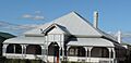
Pringle Cottage

At 81 Dragon Street, Pringle Cottage is a much smaller, but equally important, historic home. It gives us a look at what a typical house might have been like for early settlers in Warwick. These simpler homes are just as valuable as grand mansions because they show the everyday lives of people who built the town.
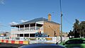
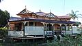
Warwick Court House

The Warwick Court House on Fitzroy Street is a grand building that has been used for legal matters for many years. Built in the late 1800s, its design reflects the importance of law and order in the growing town. It's a place where many important decisions affecting the community have been made.
Warwick Town Hall

The Warwick Town Hall on Palmerin Street is another impressive building. It's where the local government meets and where many community events have taken place over the years. Town halls are often the heart of a town, representing its civic pride and history.
Schools and Education
Warwick also has historic schools that have educated generations of students.
Warwick East State School

The Warwick East State School on Fitzroy Street has been teaching children for a very long time. Old school buildings like this one are special because they remind us of how education has changed and grown over the decades.
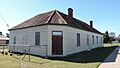
Warwick Central State School
,_Warwick,_Queensland,_2015.JPG)
Another important school is the Warwick Central State School on Guy Street. Both East and Central schools show the long commitment Warwick has had to educating its young people.
Our Lady of Assumption Convent

The Our Lady of Assumption Convent on Locke Street was once a place where nuns lived and taught. Convents played a big role in providing education, especially for girls, in earlier times.
Public Spaces and Monuments
Some heritage sites are not buildings but important public spaces or monuments.
Warwick War Memorial

The Warwick War Memorial on Fitzroy Street is a special place dedicated to remembering the soldiers from Warwick who served in wars. War memorials are important for communities to honor heroes and reflect on history.
T J Byrnes Monument

The T J Byrnes Monument on Palmerin Street is a statue dedicated to Thomas Joseph Byrnes, a former Premier of Queensland. Monuments like this help us remember important people who shaped the state's history.
Other Notable Sites
Warwick has many other interesting heritage-listed places.
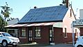
Warwick Railway Station

The Warwick railway station on Lyons Street was once a very busy hub for travel and trade. Railways were super important for connecting towns and moving goods in the past, and this station shows that history.
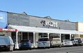
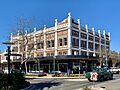
Hotels and Businesses
Places like the National Hotel on Grafton Street, the Criterion Hotel on Palmerin Street, and the Langham Hotel also on Palmerin Street, were important gathering spots. They show how people socialized and how businesses operated in Warwick long ago. Buildings like Johnson's Building and Barnes and Co. Trading Place (also known as the Smith & Miller building) were once busy shops and offices.
Churches
Besides St Mark's, the Warwick Uniting Church on Guy Street and the two St Mary's Roman Catholic Churches on Palmerin Street are also heritage-listed. These churches show the different faiths and communities that have made up Warwick over time.
Warwick General Cemetery

The Warwick General Cemetery on Wentworth Street is a quiet place where many of Warwick's past residents are buried. Cemeteries can be important historical sites, with old headstones telling stories of the people who lived in the town.
Images for kids
-
Glennie Hall
-
The Commonage
-
Plumb's Chambers
-
Tulloch's Central Stores
-
Residence, 50 Guy Street
-
St George's Masonic Centre
-
Johnson's Building
-
Barnes and Co. Trading Place
-
St Mary's Presbytery
-
Oddfellows Home Hotel
-
Aberfoyle


