Little Tomhicken Creek facts for kids
Quick facts for kids Little Tomhicken Creek |
|
|---|---|

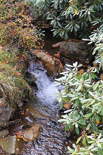
Little Tomhicken Creek looking upstreamin its middle reaches
|
|
| Physical characteristics | |
| Main source | strip mine on Green Mountain in East Union Township, Schuylkill County, Pennsylvania 1,500 to 1,520 feet (460 to 460 m) |
| River mouth | Tomhicken Creek in North Union Township, Schuylkill County, Pennsylvania 1,200 ft (370 m) 40°54′59″N 76°08′36″W / 40.91634°N 76.14342°W |
| Length | 1.0 mi (1.6 km) |
| Basin features | |
| Progression | Tomhicken Creek → Catawissa Creek → Susquehanna River → Chesapeake Bay |
| Basin size | 4.31 sq mi (11.2 km2) |
Little Tomhicken Creek is a small stream in Schuylkill County, Pennsylvania. It flows into Tomhicken Creek. The creek is about 1.0 mile (1.6 km) long. It runs through East Union Township and North Union Township. The land area that drains into the creek is about 4.31 square miles (11.2 km2).
Even though it's called a Coldwater Fishery, the creek has no fish. This is because of pollution from old mines. The water quality is also very low. The main rocks in the area are the Mauch Chunk and Pottsville Formations. The soil is mostly Hazleton soil. Most of the creek flows close to a road.
Contents
Where Does Little Tomhicken Creek Flow?
Little Tomhicken Creek starts in a strip mine on Green Mountain. This is near Cove Mountain Drive in East Union Township. It flows north for a short distance. Soon after, it enters a valley.
The creek then turns northeast for a bit. After that, it turns north again. It flows next to Nuremberg Road for several tenths of a mile. The creek then enters North Union Township. It continues flowing north. A short distance downstream, it joins Tomhicken Creek. Little Tomhicken Creek meets Tomhicken Creek about 6.03 miles (9.70 km) before Tomhicken Creek reaches its own end.
Why Is the Water Quality Low?
The Pennsylvania Department of Environmental Protection says Little Tomhicken Creek is unhealthy for aquatic life. This is mainly due to acid mine drainage and low pH levels. Acid mine drainage is polluted water from old mines.
There is one source of this pollution near the creek's mouth. Also, old strip mines at the creek's start add more acid mine drainage. This makes the creek's water very acidic. It greatly harms the water quality.
The pH of Little Tomhicken Creek is 4.4. A pH of 7 is neutral, so 4.4 is quite acidic. The water has 0 milligrams per liter of alkalinity. Alkalinity helps water resist changes in pH. The water hardness is 22 milligrams per liter.
In 1997, the air temperature near the creek was 30 °C (86 °F). The water temperature was 15.5 °C (59.9 °F). The water's specific conductance was 107 μmhos. This measures how well water conducts electricity, which can show how many dissolved substances are in it.
Land and Rocks Around the Creek
The land near where Little Tomhicken Creek joins Tomhicken Creek is about 1,200 feet (370 m) above sea level. The creek's source is higher, between 1,500 feet (460 m) and 1,520 feet (460 m) high. Most of the land around the creek is high up.
The main rock formations in the area are the Mauch Chunk Formation and the Pottsville Formation. The soil is mostly Hazleton soil. There are not many places that flood in the creek's watershed. The creek starts near a mountain called Green Mountain.
A mine tunnel called the Oneida Number 3 Tunnel releases water into Little Tomhicken Creek. This tunnel is a major source of acid mine drainage in the larger Catawissa Creek area. Little Tomhicken Creek is quite narrow, about 4.6 ft (1.4 m) wide. It drops quickly, about 310 ft/mi (59 m/km), which means it flows downhill steeply.
The Creek's Surroundings and History
The area that drains into Little Tomhicken Creek is about 4.31 square miles (11.2 km2). Most of this area is in East Union Township. However, some parts are in North Union Township. There is some agricultural land near where the creek begins.
Nuremberg Road runs alongside Little Tomhicken Creek for much of its path. Chapel Road is also in the northern part of the area. Pennsylvania Route 924 crosses the area from north to south. About 91 percent of the creek's length is within 330 ft (100 m) of a road. All of its length is within 980 ft (300 m) of a road. In 1990, about 21 people lived in each square kilometer of the watershed.
Little Tomhicken Creek is located in the Nuremberg area on United States Geological Survey maps. In the 1990s, there was some building development near the creek's source. In 2009, a special system was put in place to treat the water from the Oneida Number Three Tunnel. But heavy rain in 2011 damaged it, making it useless.
Why Are There No Fish?
The Pennsylvania Department of Environmental Protection calls Little Tomhicken Creek a Coldwater Fishery. This means it should be cold enough for fish like trout. However, a report from 1997 suggested not doing much to manage the creek. This was because of its very low water quality. The Pennsylvania Fish and Boat Commission also does not manage the creek for the same reason.
Because of the acid mine drainage, no part of the creek can support fish. There are simply no fish living in it. The 1997 report also said that Little Tomhicken Creek was not a good place for fishing. Interestingly, Rainbow trout used to live in Little Tomhicken Creek in the early 1900s.
 | Audre Lorde |
 | John Berry Meachum |
 | Ferdinand Lee Barnett |


