
Little Yosemite Valley facts for kids
Quick facts for kids Little Yosemite Valley |
|
|---|---|

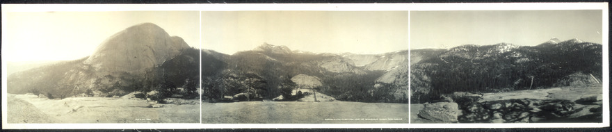
Little Yosemite Valley from Washburn Point
|
|

Little Yosemite Valley Topographic Map
|
|
| Floor elevation | 6,150 feet (1,870 m) |
| Length | 3.5 miles (5.6 km) |
| Geography | |
Little Yosemite Valley is a beautiful, smaller valley in Yosemite National Park. It's located upstream from the main Yosemite Valley along the Merced River. The Merced River winds through this flat, 3.5-mile-long valley. It then flows over two big waterfalls, Nevada Fall and Vernal Fall, before reaching the main Yosemite Valley.
You can reach Little Yosemite Valley by hiking from the main Yosemite Valley. It's a very popular spot in the Yosemite Wilderness. The valley is a great starting point for adventures. From here, you can explore places like the back side of Half Dome and Clouds Rest. You can also visit the Merced Lake High Sierra Camp.
Little Yosemite Valley is part of a "glacial stairway" along the Merced River. This stairway climbs from Yosemite Valley up towards Mount Lyell. The valley itself is about 2,000 feet higher than the main Yosemite Valley.
Contents
Valley's Amazing Geology

Little Yosemite Valley was carved by huge glaciers long ago. These glaciers shaped the land, creating its unique features. The rocks here tell an amazing story of ice and time.
The north wall of Little Yosemite Valley looks different from the south wall. Its granite rocks are very tough and strong. This means the glaciers didn't smooth them down as much. Even though huge glaciers passed through here, the rocks stayed mostly intact. They mostly eroded along natural cracks called exfoliation joints.
The south wall of the valley was smoothed a lot by the glaciers. Its granite cliffs are very stark and flat. You can see this in the picture of the valley from Washburn Point. This smooth rock means there are few places for plants to grow. The north wall, however, has more cracks and plants, similar to the north wall of Yosemite Valley.
Cool Places to See
Liberty Cap and Mount Broderick

Liberty Cap is a large granite dome in Yosemite National Park. It sits at the edge of Little Yosemite Valley. This dome is right next to Nevada Fall on the John Muir Trail. It rises about 1,700 feet from the base of Nevada Fall. Its peak is about 7,076 feet high.
Next to Liberty Cap is a smaller, flat-topped dome called Mount Broderick. These two domes create a natural barrier at the entrance of Little Yosemite Valley. Both Liberty Cap and Mount Broderick are "roches moutonnées." This means they are rock formations that resisted being worn down by glaciers. They are smooth on the side where the glacier pushed against them. The other side is rougher.
Half Dome: A Famous Landmark

Half Dome is a famous granite dome in Yosemite National Park. It's located at the northwest end of Little Yosemite Valley. This rock formation is probably the most recognized symbol of Yosemite. The granite crest rises over 4,737 feet above the Yosemite Valley floor. It's also 2,686 feet above the floor of Little Yosemite Valley.
The trail to Half Dome splits off from the main Little Yosemite Valley trail. You'll find this turn near the ranger station and campground.
Moraine Dome: Glacial Clues

Moraine Dome is another granite dome in Yosemite National Park. It's located along the northern edge of Little Yosemite Valley. This dome rises to an elevation of 8,036 feet. That's about 1,906 feet above the Merced River.
Moraine Dome is special because of its lateral moraines. These are piles of rock and dirt left behind by the Merced Glacier. They likely show the highest point that glacial ice reached in Little Yosemite Valley. The southwest side of Moraine Dome has a wide, striped granite slope. It looks like a "granite apron" that rises about 500 feet from the valley floor.
Sugar Loaf Dome and Cascade Fall

Sugar Loaf Dome is a granite dome at the northeast end of Little Yosemite Valley. It rises to 7,697 feet high. Even though glaciers passed over Sugar Loaf Dome many times, its core remained strong. This is because it's made of very solid granite.
This dome is about 1,300 feet higher than the Merced River. Its shoulder changes the river's path. This change creates Cascade Fall, where the river flows down into Little Yosemite Valley.

Cascade Fall is located at the eastern end of Little Yosemite Valley. The water tumbles over smooth granite into a lovely pool. This waterfall is sometimes confused with Bunnell Cascade, which is in a different area.
Bunnell Point and Cascade Cliffs

Bunnell Point is a granite dome peak in California. It rises to 8,173 feet high. This point forms the southeast edge of Little Yosemite Valley.

Cascade Cliffs are tall walls of solid granite. They rise to 8,170 feet high, about 1,930 feet above the Merced River. These cliffs form the southern wall of Little Yosemite Valley. The granite here is incredibly solid, with very few cracks. The dark streaks you see on the cliffs are from ribbon cascades. These small waterfalls appear in spring when the snow melts. There are also two wide, deep arches at the bottom of the cliffs.
The Quarter Domes
The Quarter Domes are two granite domes located between Half Dome and Clouds Rest. They are called West Quarter Dome and East Quarter Dome. East Quarter Dome is the taller of the two, reaching 8,318 feet. West Quarter Dome is 8,160 feet high.
Visitor Facilities
Hiking Trail
The Merced River enters Little Yosemite Valley at 6,185 feet elevation. It leaves the valley at 5,907 feet. This means the river drops about 278 feet over the 3.25-mile trail length.
The trail is mostly covered by trees. However, there are two open areas. One is a short section near Moraine Dome. The second is a quarter-mile section of burned forest. This section is about 2.3 miles above Nevada Fall, across from Cascade Cliffs.
Campground Information
The hike-in campground in Little Yosemite Valley is a popular spot. It's a little under 4 miles from the trailhead in Yosemite Valley. It's also about 3.5 miles from the summit of Half Dome.
You can have fires in the two shared campfire rings outside the campground. There is no drinking water available directly at the campground. However, you can get water from the nearby Merced River. The river is the only water source in the area. The Little Yosemite Valley Ranger Station is open during the summer. A composting toilet is also available near the campground.
The Park Service provides special food lockers at the campground. These are for storing your food, toiletries, and trash safely. This helps protect them from the many black bears that visit Little Yosemite.
