Clouds Rest facts for kids
Quick facts for kids Clouds Rest |
|
|---|---|

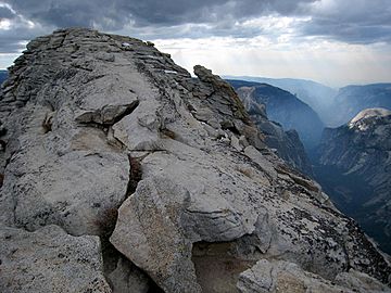
The summit of Cloud's Rest.
|
|
| Highest point | |
| Elevation | 9,930 ft (3,027 m) |
| Prominence | 806 ft (246 m) |
| Parent peak | Tresidder Peak |
| Listing |
|
| Geography | |
| Location | Yosemite National Park, Mariposa County, California, U.S. |
| Parent range | Sierra Nevada |
| Topo map | USGS Tenaya Peak |
| Climbing | |
| Easiest route | Trail hike, class 1 |
Clouds Rest is a tall and famous mountain located in Yosemite National Park in California, U.S.. It stands east-northeast of Yosemite Valley. Even though some other mountains in the park are even taller, Clouds Rest stands out. This is because it's very close to the valley, making it look really impressive from many viewpoints.
Contents
What is Clouds Rest?
Clouds Rest is a special type of mountain called an arête. Imagine a thin, sharp ridge of rock, almost like a knife blade. This shape was carved by huge glaciers long ago. These glaciers slowly wore away the solid rock. They helped form Tenaya Canyon and Little Yosemite Valley around the mountain.
The northwest side of Clouds Rest is mostly solid granite. It rises about 5,000 feet (1,520 m) above Tenaya Creek. This makes it a very dramatic sight.
How Clouds Rest Got Its Name
A medical doctor named Lafayette H. Bunnell was part of the Mariposa Battalion. He wrote about how his group named the mountain. They saw "the clouds rapidly settling down to rest upon that mountain." Because of this, they decided to call it Clouds Rest. This happened when they returned to camp to avoid a snow storm.
Exploring Clouds Rest
There are a few main ways to reach the top of Clouds Rest. Hikers can choose different paths depending on how long and challenging they want their adventure to be.
Hiking Trails
One popular way to reach the summit is by hiking from the Tioga Pass Road. This trail is about 7.2-mile (11.6 km) long. Another option is a longer hike from Happy Isles in Yosemite Valley. This route is about 13-mile (21 km) and goes through Little Yosemite Valley.
A common hiking path is the Sunrise Lakes Trail. This trail starts off of CA-120. It's often called the Northeast Ridge Route. This round trip hike is about 14.5 miles (23.3 km) long. It begins at an elevation of 8,150 feet (2,480 m). Hikers gain about 1,776 feet (541 m) in elevation to reach the summit. The summit is at 9,926 feet (3,025 m).
Amazing Views
When you reach the top of Clouds Rest, you get incredible views. You can see all around you, with wide-ranging 360-degree panoramic sights. It's a truly rewarding experience for hikers.
 | Aurelia Browder |
 | Nannie Helen Burroughs |
 | Michelle Alexander |

