Littlerock, California facts for kids
Quick facts for kids
Littlerock, California
|
|
|---|---|

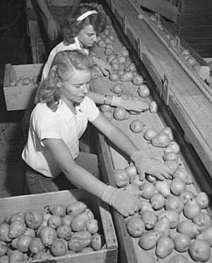
Workers sorting pears, Bones & Son packinghouse, Littlerock 1946. Packers were promised an extra 25 cents for each "wormy" pear, but found only two in 27 tons of fruit.
|
|

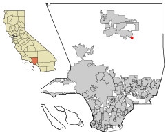
Location of Littlerock in Los Angeles County, California.
|
|
| Country | |
| State | |
| County | |
| Area | |
| • Total | 1.843 sq mi (4.774 km2) |
| • Land | 1.842 sq mi (4.770 km2) |
| • Water | 0.001 sq mi (0.004 km2) 0.08% |
| Elevation | 2,890 ft (881 m) |
| Population
(2020)
|
|
| • Total | 1,535 |
| • Density | 832.9/sq mi (321.53/km2) |
| Time zone | UTC-8 (PST) |
| • Summer (DST) | UTC-7 (PDT) |
| ZIP code |
93543
|
| Area code(s) | 661 |
| FIPS code | 06-41880 |
| GNIS feature ID | 1660929 |
Littlerock is a small community in California, United States. It's known as a census-designated place, which means it's a special area defined by the government for counting people. In 2020, about 1,535 people lived there.
The name Littlerock comes from the Little Rock Wash, a stream that flows through the area. It's also called "The Fruit Basket of the Antelope Valley" because it used to have many fruit orchards. You could find trees with almonds, apples, peaches, and pears along Highway 138.
Contents
Where is Littlerock Located?
Littlerock is about 11 miles (18 km) southeast of Palmdale's main center. It is surrounded by other places like Palmdale to the northwest and Pearblossom to the southeast. To the north is Sun Village, and to the south are the San Gabriel Mountains.
The United States Census Bureau says Littlerock covers about 1.8 square miles (4.7 square kilometers) of land. Almost all of this area is land, with very little water.
Who Lives in Littlerock?
Population Changes Over Time
The number of people living in Littlerock has changed over the years.
| Historical population | |||
|---|---|---|---|
| Census | Pop. | %± | |
| 1990 | 1,320 | — | |
| 2000 | 1,402 | 6.2% | |
| 2010 | 1,377 | −1.8% | |
| sources: | |||
People in 2010
In 2010, the 2010 United States Census counted 1,377 people in Littlerock.
- Most residents (58.7%) were White.
- About 5.4% were African American.
- Around 1.2% were Native American.
- About 1.7% were Asian.
- Roughly 0.8% were Pacific Islander.
- Many people (27.1%) were from other races, and 5.1% were from two or more races.
- A large group, 54.1%, identified as Hispanic or Latino.
Most people (99.9%) lived in regular homes.
- There were 417 households.
- Almost half (46.3%) of these households had children under 18.
- More than half (53.7%) were married couples.
- The average household had about 3.30 people.
- The average family had about 3.69 people.
The population included people of all ages:
- 30.4% were under 18 years old.
- 11.6% were between 18 and 24.
- 25.1% were between 25 and 44.
- 25.0% were between 45 and 64.
- 7.9% were 65 or older.
The average age was 32.3 years.
Most homes (64.5%) were owned by the people living in them. The rest (35.5%) were rented. In 2010, the average income for a household in Littlerock was about $42,617. About 9.5% of the people lived below the official poverty line.
People in 2000
In 2000, there were 1,402 people living in Littlerock.
- About 71.68% were White.
- About 4.78% were African American.
- About 1.07% were Native American.
- About 0.21% were Asian.
- Many people (19.76%) were from other races, and 2.50% were from two or more races.
- About 39.73% of the population was Hispanic or Latino.
There were 426 households.
- Almost half (49.3%) had children under 18.
- More than half (56.1%) were married couples.
The average household had about 3.29 people, and the average family had about 3.71 people.
The population was spread out by age:
- 38.5% were under 18.
- 7.5% were 18 to 24.
- 30.0% were 25 to 44.
- 16.5% were 45 to 64.
- 7.5% were 65 or older.
The average age was 29 years.
In 2000, the average household income was $39,000. About 23.7% of the population lived below the poverty line.
Ancestry and Birthplace
According to a project called Mapping L.A., the most common family backgrounds in Littlerock in 2000 were Mexican and German. The most common countries where people were born outside the U.S. were Mexico and El Salvador.
How to Get Around Littlerock?
Roads and Public Transport
You can reach Littlerock by road using California State Route 138. For public transportation, the Antelope Valley Transit Authority provides bus services.
Train Connections
Littlerock also has a special bus service that connects to Amtrak California's San Joaquin trains. You can catch this bus at the MB Grocery Discount store.
See also
 In Spanish: Littlerock (California) para niños
 | DeHart Hubbard |
 | Wilma Rudolph |
 | Jesse Owens |
 | Jackie Joyner-Kersee |
 | Major Taylor |


