
Lodi, Ohio facts for kids
Quick facts for kids
Lodi, Ohio
|
|
|---|---|
|
Village
|
|

Community Park, Downtown Lodi
|
|

Location of Lodi, Ohio
|
|

Location of Lodi in Medina County
|
|
| Country | United States |
| State | Ohio |
| County | Medina |
| Founded | 1811 |
| Incorporated | 1891 (village) |
| Government | |
| • Type | Mayor-Council |
| Area | |
| • Total | 2.26 sq mi (5.85 km2) |
| • Land | 2.25 sq mi (5.83 km2) |
| • Water | 0.01 sq mi (0.02 km2) |
| Elevation | 906 ft (276 m) |
| Population
(2020)
|
|
| • Total | 2,746 |
| • Density | 1,219.90/sq mi (470.95/km2) |
| Time zone | UTC-5 (Eastern (EST)) |
| • Summer (DST) | UTC-4 (EDT) |
| ZIP code |
44254
|
| Area code(s) | 330 |
| FIPS code | 39-44604 |
| GNIS feature ID | 2398466 |
Lodi (/ˈloʊdaɪ/ LOH-dye) is a small village in Medina County, Ohio, United States. It is located southwest of the city of Medina. In 2020, about 2,746 people lived there.
Contents
History of Lodi
Lodi was founded in 1811, making it the oldest settlement in Medina County. It was first called Harrisville, named after Judge Joseph Harris. The village's name was later changed to Lodi. This new name came from a city in northern Italy where Napoleon won an important battle in 1796. Lodi officially became a village in 1891.
An early settler named Redfield helped create a path through the trees to Medina. This path was later made straighter and became part of U.S. Route 42.
Geography of Lodi
Lodi is located along the East Fork of the Black River. The village covers an area of about 2.26 square miles (5.85 square kilometers). Most of this area is land, with a small part being water.
The East Fork of the Black River flows into Lodi from the north. It then turns back north and eventually empties into Lake Erie. Lodi is on a special line called the north–south continental divide. This means that rainwater falling in Lodi can flow in two different directions. Some water flows north towards Lake Erie, while other water flows south towards the Ohio River.
Population of Lodi
| Historical population | |||
|---|---|---|---|
| Census | Pop. | %± | |
| 1880 | 437 | — | |
| 1890 | 568 | 30.0% | |
| 1900 | 846 | 48.9% | |
| 1910 | 1,015 | 20.0% | |
| 1920 | 1,240 | 22.2% | |
| 1930 | 1,273 | 2.7% | |
| 1940 | 1,304 | 2.4% | |
| 1950 | 1,523 | 16.8% | |
| 1960 | 2,213 | 45.3% | |
| 1970 | 2,399 | 8.4% | |
| 1980 | 2,942 | 22.6% | |
| 1990 | 3,042 | 3.4% | |
| 2000 | 3,061 | 0.6% | |
| 2010 | 2,746 | −10.3% | |
| 2020 | 2,746 | 0.0% | |
| U.S. Decennial Census | |||
Lodi's Population in 2010
In 2010, there were 2,746 people living in Lodi. The village had 1,178 households. Most of the people living in Lodi were White (98.1%). About 1.1% of the population identified as Hispanic or Latino.
Education in Lodi
Lodi has a school system that works with nearby communities. Younger students attended Lodi Primary School for preschool through second grade. Students in grades three and four went to Seville Intermediate School. Fifth and sixth graders attended Westfield Upper Elementary.
For middle school and high school, students from Lodi join students from Chatham, Lafayette, Westfield Center, and Seville. Together, they form Cloverleaf Middle School and Cloverleaf High School.
Lodi also has a public library. It is a branch of the Medina County District Library system.
Culture and Events
Lodi used to host an event called the Sweet Corn Festival every July. This festival included a parade, fair food, and amusement rides. The last Sweet Corn Festival was held in 2019.
Since 2019, Lodi has started a new event called the Annual Parkstock Music Festival. This festival brings together different bands. The money raised from this event helps support the local parks in Lodi.
Images for kids
-
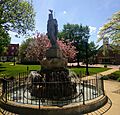
Community Park, Downtown Lodi
-
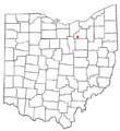
Location of Lodi, Ohio
-

Location of Lodi in Medina County
See also
 In Spanish: Lodi (Ohio) para niños
