
Logar Province facts for kids
Quick facts for kids Logar (لوګر) |
|
| Province | |
| Country | Afghanistan |
|---|---|
| Capital | Pul-i-Alam |
| - coordinates | 34°00′N 69°12′E / 34.0°N 69.2°E |
| Area | 3,880 km² (1,498 sq mi) |
| Population | 332,451 and 550,300 (varying estimates) |
| Density | 120 /km² (311 /sq mi) |
| Timezone | UTC+4:30 |
| Main languages | Pashto Dari Persian |
Logar (pronounced LOH-gar) is one of the 34 provinces in Afghanistan. It is located in the eastern part of the country. Many people living here are from the Pashtun group. The capital city of Logar Province is Pul-i-Alam.
What are the Districts of Logar Province?

Logar Province is divided into several smaller areas called districts. Each district has its own unique features. Here are the main districts:
| District | Capital | Population | Area | Notes |
|---|---|---|---|---|
| Azra | 14,550 | Moved from Paktia Province in 2005 | ||
| Baraki Barak | 78,063 | Has a main road connecting to Highway 1 | ||
| Charkh | 40,492 | Divided into smaller parts in 2005 | ||
| Kharwar | 26,607 | Formed in 2005 from part of Charkh District | ||
| Khoshi | 15,127 | Home to many Shia communities | ||
| Mohammad Agha | 58,979 | Its northern part is close to the city of Kabul | ||
| Pul-i-Alam | 88,886 | Includes the capital city of Logar |
 |
Kabul Province | |
||
| Wardak Province | Nangarhar Province | |||
| Ghazni Province | Paktia Province | Federally Administered Tribal Areas, |
Images for kids
-
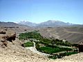
The main river valley in the Khoshi District of Logar province. Water for farming comes from special irrigation systems called karez.
-
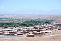
Puli Alam, the capital of Logar province.


See also
 In Spanish: Provincia de Laugar para niños

All content from Kiddle encyclopedia articles (including the article images and facts) can be freely used under Attribution-ShareAlike license, unless stated otherwise. Cite this article:
Logar Province Facts for Kids. Kiddle Encyclopedia.