
Nangarhar Province facts for kids
Quick facts for kids Nangarhar (ننګرهار) |
|
| Province | |
| Country | Afghanistan |
|---|---|
| Capital | Jalalabad |
| - coordinates | 34°15′N 70°30′E / 34.25°N 70.50°E |
| Area | 7,727 km² (2,983 sq mi) |
| Population | 1,436,000 (2013) |
| Governor | Gul Agha Shirzai |
| Timezone | GMT+4:30 |
| Main language | Pashto |
Nangarhar (Pashto: ننګرهار Nangarhār) is one of the 34 provinces in Afghanistan. It is located in the eastern part of the country. The capital city of Nangarhar is Jalalabad. Around 1.4 million people live in this province. The main language spoken here is Pashto.
Nangarhar's Districts

Nangarhar province is divided into 22 smaller areas called districts. Each district helps manage the local communities. Some of these districts were created or changed in 2005 to better organize the province. For example, the Jalalabad District was divided into smaller parts.
 |
Laghman Province | Kunar Province | |
|
| Kabul Province | ||||
| Logar Province | Federally Administered Tribal Areas, |
Images for kids
-
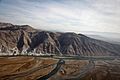
Branches of the Kunar River meet with the Kabul River in Nangarhar
-
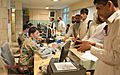
Inside the Afghan customs and border patrol station at the Torkham border crossing in 2013
-
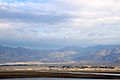
Nangarhar Overview
-
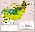
Ethnolinguistic groups in Afghanistan
-
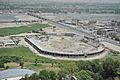
The Sherzai Cricket Stadium under construction in June 2011


See also
 In Spanish: Provincia de Nangarjar para niños
