
Kunar Province facts for kids
Quick facts for kids Kunar |
|
| Province | |
 |
|
| Country | Afghanistan |
|---|---|
| Capital | Asadabad |
| - coordinates | 35°00′N 71°12′E / 35.0°N 71.2°E |
| Population | 413,008 |
| Timezone | UTC+4:30 |
| Main language | Pashto |
Kunar is one of the 34 provinces of Afghanistan. It is located in the northeastern part of the country. The capital city of Kunar is Asadabad. About 428,800 people live in Kunar Province.
Kunar is known as one of the four "N2KL" provinces. This name was used by forces in Afghanistan for a tough region. It is located along the Durand Line border. This border is opposite parts of Pakistan.
Kunar is also the birthplace of Sayyed Jamaluddin Afghani. He was a very important Muslim scholar and thinker.
You might have seen Kunar Province in a movie! The start of the 2008 film Iron Man happens in Kunar Province.
Exploring Kunar's Geography

Kunar Province is in the northeast of Afghanistan. It shares borders with other provinces. To the south is Nangarhar Province. Nuristan Province is to the north. Laghman Province is to the west. Kunar also has a border with Pakistan in the east.
The province covers an area of 4,339 square kilometers. Most of Kunar, about 86%, is mountainous. The rest, about 12%, is flatter land. The main mountains here are part of the lower Hindu Kush range.
The Kunar River flows through these mountains. It creates the Kunar Valley. This river starts in the Pamir area. It flows south and southwest. The Kunar River is part of the Indus River system. It connects through the Kabul River.
The mountains, narrow valleys, and rivers make travel hard. Moving around the province is very difficult. This is true even today. People often travel on foot or with animals. Roads for vehicles are very limited.
Images for kids
-
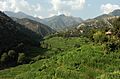
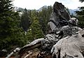
View of the Korangal Valley
-
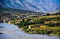
Nari District
-
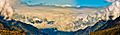
Panorama of a mountain range near Naray, Kunar province, Afghanistan
-
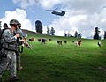
US soldiers near FOB (Forward Operating Base) Naray.
-
A soldier observes the mountain landscape opposite of his position that surrounds the Korengal Valley
-
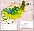
Ethnolinguistic groups of Afghanistan
-
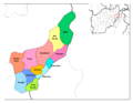
Districts of Kunar
-
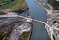
A bridge in Kunar province.


See also
 In Spanish: Provincia de Kunar para niños
