
Laghman Province facts for kids
Quick facts for kids
Laghman
لغمان
|
|
|---|---|

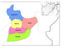
The location of Laghman Province within Afghanistan
|
|
| Country | |
| Capital | Mehtar Lam |
| Area | |
| • Total | 3,843 km2 (1,484 sq mi) |
| Population
(2008)
|
|
| • Total | 382,280 |
| • Density | 99.474/km2 (257.64/sq mi) |
| Time zone | UTC+4:30 |
| Main languages | [Pashto] |
Laghman (in Persian and Pashto: لغمان) is one of the 34 provinces in Afghanistan. It is located in the eastern part of the country. The capital city of Laghman Province is Mehtar Lam.
Districts of Laghman Province
A province is often divided into smaller areas called districts. Laghman Province has several districts, each with its own main town or capital. These districts help manage different parts of the province.
| District | Capital | Population | Area | Notes |
|---|---|---|---|---|
| Alingar | 89,716 | |||
| Alishing | 68,153 | |||
| Dawlat Shah | 40,887 | |||
| Mihtarlam | 112,856 | |||
| Qarghayi | 70,688 | |||
| Baad Pukh | New District |
Where is Laghman Province?
Laghman Province is located in eastern Afghanistan. It shares borders with several other provinces. Knowing its neighbors helps us understand its place on the map.
 |
Panjshir Province | Nuristan Province | |
|
| Kapisa Province | Kunar Province | |||
| Kabul Province | Nangarhar Province |
Images for kids
-

A village sits in a valley in the Hindu Kush Mountain Range in Laghman Province
-
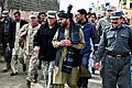
U.S. Army Gen. David Petraeus walking with Governor Iqbal Azizi in 2011.
-
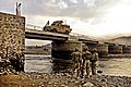
Members of the U.S. Air Force inspecting the underside of a bridge as traffic squeezes through the narrow roadway in Mihtarlam.
-
Districts of Laghman Province


See also
 In Spanish: Provincia de Lagmán para niños
