
Kapisa Province facts for kids
Quick facts for kids
Kapisa
کاپیسا
|
|
|---|---|
|
Province
|
|

Map of Afghanistan with Kapisa highlighted
|
|
| Country | |
| Capital | Mahmud-i-Raqi |
| Area | |
| • Total | 1,842.1 km2 (711.2 sq mi) |
| Population
(2015)
|
|
| • Total | 441,010 |
| • Density | 239.406/km2 (620.059/sq mi) |
| Time zone | UTC+4:30 |
| ISO 3166 code | AF-KAP |
| Main languages | Pashto, Persian and Pashayi |
Kapisa (which is کاپيسا in Pashto and Persian) is one of the 34 provinces in Afghanistan. It is located in the north-east part of the country. The main city and capital of Kapisa is Mahmud-i-Raqi.
Kapisa province is about 80 kilometers (50 miles) north-east of Kabul, the capital city of Afghanistan. In 2015, about 441,010 people lived in this province. The main languages spoken here are Pashto, Persian, and Pashayi.
Districts of Kapisa

Kapisa province is divided into several smaller areas called districts. Each district has its own center. This helps to manage the different parts of the province.
Here are the districts that make up Kapisa Province:
| District | District Center | Population | Area | Notes |
|---|---|---|---|---|
| Alasay | ||||
| Hesa Awal Kohistan | This district was created in 2005 from parts of the old Kohistan District. | |||
| Hesa Duwum Kohistan | This district was also created in 2005 from parts of the old Kohistan District. | |||
| Koh Band | ||||
| Mahmud Raqi | ||||
| Nijrab | ||||
| Tagab |
Where is Kapisa Province?
Kapisa Province is surrounded by other provinces in Afghanistan. Knowing its neighbors helps us understand its location better.
Here are the provinces that share a border with Kapisa:
 |
Panjshir Province | |
||
| Parwan Province | Laghman Province | |||
| Kabul Province |
Images for kids
-
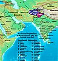
Asia in AD 565, showing the Shahi kingdoms and their neighbors.
-
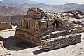
Newly excavated Buddhist stupa at Mes Aynak in Logar Province of Afghanistan. Similar stupas have been discovered in neighboring Ghazni Province, including in the northern Samangan Province.
-
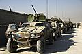
French army soldiers prepare their vehicles for a convoy prior to departing camp for Operation Eagle, October 2008
-
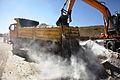
Afghan construction workers, work on a road construction project in Mahmood Rahqi.
-
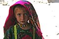
A young Pashai girl wearing distinctively colored and patterned clothing
-

Saffron harvesting ceremony in Kapisa Province


See also
 In Spanish: Provincia de Kapisa para niños
