London Township, Michigan facts for kids
Quick facts for kids
London Township, Michigan
|
||
|---|---|---|

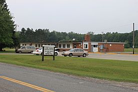
Municipal Building on Tuttle Hill Road
|
||
|
||

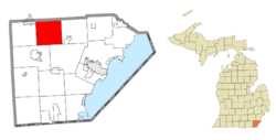
Location within Monroe County and the state of Michigan
|
||
| Country | United States | |
| State | Michigan | |
| County | Monroe | |
| Established | 1833 | |
| Area | ||
| • Total | 35.87 sq mi (92.9 km2) | |
| • Land | 35.76 sq mi (92.6 km2) | |
| • Water | 0.11 sq mi (0.3 km2) | |
| Elevation | 663 ft (202 m) | |
| Population | ||
| • Total | 2,984 | |
| • Density | 83.5/sq mi (32.2/km2) | |
| Time zone | UTC-5 (Eastern (EST)) | |
| • Summer (DST) | UTC-4 (EDT) | |
| ZIP Codes | ||
| Area code(s) | 734 | |
| FIPS code | 26-115-49180 | |
| GNIS feature ID | 1626639 | |
London Township is a community in Monroe County, Michigan, USA. It is a type of local government area called a "civil township." In 2020, about 2,984 people lived here.
Contents
History of London Township
London Township was created a long time ago, in 1833. This means it has been a community for nearly 200 years!
Communities in London Township
Inside London Township, there are a couple of smaller communities. These are called "unincorporated communities" because they don't have their own separate local government.
- London is one of these communities. It started with a post office way back on December 22, 1832. This post office served the area until 1905.
- Oakville is another community in the northern part of the township. People first settled here around 1831. It had a post office that opened and closed a few times. It was first called Readingville, then Nelsonville, and finally Oakville. The Oakville post office closed in 1904.
Geography of London Township
London Township is located in the northern part of Monroe County. Its northern border is right next to Washtenaw County.
The center of the township is about 5 miles (8 km) southeast of Milan. It's also about 6 miles (10 km) northwest of Maybee. The county seat of Monroe County, which is the city of Monroe, is about 14 miles (23 km) northwest of London Township.
The township covers a total area of about 35.87 square miles (92.90 square kilometers). Most of this area is land, about 35.76 square miles (92.62 square kilometers). A small part, about 0.11 square miles (0.28 square kilometers), is water. This means only a tiny bit of the township is covered by water.
You can find the start of Paint Creek at the northern border of the township, where it meets Stony Creek.
Population Over Time
The number of people living in London Township has changed quite a bit over the years. Here's a look at the population counts from different U.S. censuses:
| Historical population | |||
|---|---|---|---|
| Census | Pop. | %± | |
| 1850 | 626 | — | |
| 1860 | 839 | 34.0% | |
| 1870 | 1,031 | 22.9% | |
| 1880 | 1,408 | 36.6% | |
| 1890 | 1,315 | −6.6% | |
| 1900 | 1,271 | −3.3% | |
| 1910 | 1,128 | −11.3% | |
| 1920 | 1,032 | −8.5% | |
| 1930 | 1,119 | 8.4% | |
| 1940 | 1,273 | 13.8% | |
| 1950 | 1,591 | 25.0% | |
| 1960 | 2,422 | 52.2% | |
| 1970 | 2,522 | 4.1% | |
| 1980 | 3,266 | 29.5% | |
| 1990 | 2,915 | −10.7% | |
| 2000 | 3,024 | 3.7% | |
| 2010 | 3,048 | 0.8% | |
| 2020 | 2,984 | −2.1% | |
| U.S. Decennial Census | |||
As of the 2000 census, there were 3,024 people living in the township. The population density was about 84.7 people per square mile. This means that, on average, about 85 people lived in every square mile of land.
The population included people of different ages. About 29.6% of the people were under 18 years old. About 8.4% of the people were 65 years old or older. The average age of people in the township was 35 years.
Images for kids
See also
 In Spanish: Municipio de London (Míchigan) para niños


