Long Island (California) facts for kids

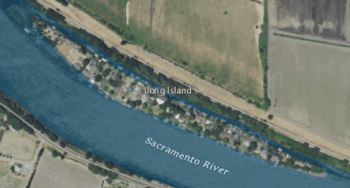
USGS aerial imagery of Long Island in the w:Sacramento River; to the south is w:Brannan Island, and to the north a bridge connects to Grand Island.
|
|
| Geography | |
|---|---|
| Location | Northern California |
| Coordinates | 38°10′01″N 121°37′30″W / 38.16694°N 121.62500°W |
| Adjacent bodies of water | Sacramento–San Joaquin River Delta |
| Highest elevation | 7 ft (2.1 m) |
| Administration | |
|
United States
|
|
| State | |
| County | Sacramento |
Long Island is a small island located in the Sacramento–San Joaquin River Delta in Northern California. It is part of Sacramento County. This island is quite low, with its highest point being only about 7 feet (2.1 meters) above sea level.
Where is Long Island?
Long Island sits within the large network of waterways known as the Sacramento–San Joaquin River Delta. This delta is where the Sacramento River and the San Joaquin River meet. These rivers then flow into San Francisco Bay. The delta is a very important area for both nature and farming.
The island's exact location is at coordinates 38°10′01″N 121°37′30″W. The United States Geological Survey (USGS) officially recorded its elevation in 1981.
What is the Sacramento–San Joaquin River Delta?
The Sacramento–San Joaquin River Delta is a huge area of islands and waterways. It was formed over many years by the rivers carrying soil and sand. This created a flat, fertile land. People have built levees, which are like walls, to protect the land from floods.
The delta is home to many different kinds of plants and animals. It is also a major agricultural region. Farmers grow many crops on the rich soil of the delta islands.


