Loop Creek (West Virginia) facts for kids
Quick facts for kids Loop Creek |
|
|---|---|

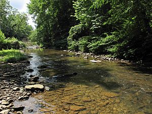
Loop Creek near Robson
|
|

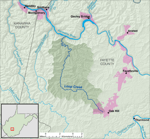
A map of Loop Creek and its watershed
|
|
| Country | United States |
| State | West Virginia |
| County | Fayette |
| Physical characteristics | |
| Main source | Oak Hill 1,946 ft (593 m) 37°58′28″N 81°09′45″W / 37.9745558°N 81.162603°W |
| River mouth | Kanawha River Deep Water 617 ft (188 m) 38°07′40″N 81°15′27″W / 38.1278852°N 81.2576092°W |
| Length | 20 mi (32 km) |
| Basin features | |
| Basin size | 49.6 sq mi (128 km2) |
| Hydrologic Unit Code | 050500060301 (USGS) |
Loop Creek, sometimes spelled Loup Creek, is a stream in West Virginia, United States. It flows for about 20 miles (32 kilometers). This creek is a tributary, which means it's a smaller stream that flows into a larger river. Loop Creek joins the Kanawha River.
The water from Loop Creek eventually travels a long way. It flows into the Kanawha River, then into the Ohio River, and finally into the mighty Mississippi River. This whole area that drains into Loop Creek is called its watershed. The Loop Creek watershed covers about 49.6 square miles (128.5 square kilometers). This area is known for coal mining and is part of the Allegheny Plateau.
Where Loop Creek Flows
Loop Creek is located entirely within Fayette County, West Virginia. It begins in the city of Oak Hill, West Virginia. From there, it flows generally northwest.
As it travels, Loop Creek passes through several small communities. These include:
After these places, the creek turns northward. It then flows through:
Finally, Loop Creek reaches Deep Water, West Virginia. This is where it empties into the Kanawha River.
The Story Behind the Name
The name "Loop Creek" comes from how the creek flows. Local history says it was named because its path is very irregular and "loopy." It doesn't flow in a straight line but makes many turns and bends. Another old name for the creek was "Loops Creek." This name is listed in the Geographic Names Information System, which keeps track of place names.
 | Janet Taylor Pickett |
 | Synthia Saint James |
 | Howardena Pindell |
 | Faith Ringgold |

