
Losser facts for kids
Quick facts for kids
Losser
|
|||
|---|---|---|---|

Monumental former factory in Losser
|
|||
|
|||
.svg)
Location in Overijssel
|
|||
| Country | Netherlands | ||
| Province | Overijssel | ||
| Government | |||
| • Body | Municipal council | ||
| Area | |||
| • Total | 99.61 km2 (38.46 sq mi) | ||
| • Land | 98.82 km2 (38.15 sq mi) | ||
| • Water | 0.79 km2 (0.31 sq mi) | ||
| Elevation | 35 m (115 ft) | ||
| Population
(May 2014)
|
|||
| • Total | 22,616 | ||
| • Density | 229/km2 (590/sq mi) | ||
| Demonym(s) | Lossernaar, Lossenaar | ||
| Time zone | UTC+1 (CET) | ||
| • Summer (DST) | UTC+2 (CEST) | ||
| Postcode |
7580–7589
|
||
| Area code | 053, 0541 | ||


Losser is a municipality and a town in the eastern Netherlands. It is located where the A1 motorway ends in the east. Losser is known for its rich history and beautiful natural surroundings.
Exploring Losser: A Dutch Municipality
Losser is a municipality, which means it's like a local government area, in the Overijssel province of the Netherlands. It includes the main town of Losser and several smaller villages.
Villages and Towns in Losser
The municipality of Losser is made up of several smaller communities. These are often called "population centres."
- Beuningen
- De Lutte
- Glane
- Losser (the main town)
- Overdinkel
The History of Losser Town
The town of Losser has a long history. The first time Losser was mentioned in writing was around the tenth century. Back then, the village was split into two separate parts.
Major Events in Losser's Past
A big event in Losser's history happened on September 21, 1665. Troops from Münster attacked and burned almost both parts of the village. This caused a lot of damage.
Losser's Oldest Building: Martinustoren
One of the oldest buildings still standing in Losser is the Martinustoren, also known as St. Martin's Tower. It was built around the year 1500. This tower is the only part left of a church that was taken down in 1903.
Losser's Geography and Nature
Losser is located in a beautiful natural area. It has interesting land features and an important river.
The Tankenberg Hill
A few kilometers west of the village of De Lutte, near the border with Oldenzaal, you'll find the Tankenberg. This is a hill, and its top is 85 meters high. This makes it the highest point in the entire province of Overijssel! There are old myths and stories connected to the Tankenberg.
The Dinkel River
The most important river in the Losser municipality is the Dinkel. Rivers like the Dinkel are vital for the local environment and often for farming.
International Connections: Sister Cities
Losser has a "sister city" relationship with another town. This means they have a special friendship to encourage cultural exchange and understanding.
 Emsbüren, Germany
Famous People from Losser
Many interesting people have come from Losser and its surrounding villages.
- Pi de Bruijn (born 1942 in Losser): A famous Dutch architect who designs buildings.
- Kim Kötter (born 1982 in Losser): A Dutch director, model, and beauty pageant winner.
- Moniek Nijhuis (born 1988 in Overdinkel): A Dutch swimmer who competed in the 2012 Summer Olympics.
Gallery
-
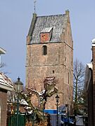
Martin's Tower
-
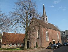
Reformed church
-
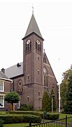
Church: de Sint Martinuskerk
-
Overdinkel, Rooms katholieke Kerk


See also
 In Spanish: Losser para niños
