
Overijssel facts for kids
Quick facts for kids
Overijssel
|
|||
|---|---|---|---|
|
|||
| Anthem: "Aan de rand van Hollands gouwen" "On the edge of Holland's district" |
|||

Location of Overijssel in the Netherlands
|
|||
| Country | Netherlands | ||
| Capital | Zwolle | ||
| Largest city | Enschede | ||
| Area | |||
| • Total | 3,327 km2 (1,285 sq mi) | ||
| • Water | 94 km2 (36 sq mi) | ||
| Area rank | 4th | ||
| Population | |||
| • Total | 1,142,360 | ||
| • Rank | 7th | ||
| • Density | 343.36/km2 (889.30/sq mi) | ||
| • Density rank | 7th | ||
| ISO 3166 code | NL-OV | ||
| Religion (2006) | Protestant 29% Catholic 26% Muslim 2% Others 6% Non-religious 37% |
||
| HDI (2017) | 0.917 very high · 7th |
||
| Website | www.overijssel.nl | ||


Overijssel is a province in the Netherlands. It is located in the central eastern part of the country. The name "Overijssel" means "Lands across the river IJssel" in both Dutch and Latin. The capital city of Overijssel is Zwolle. The biggest city in the province is Enschede.
Contents
Exploring Overijssel's Landscape
Overijssel shares a border with Germany to the east. To the south, you'll find the Achterhoek region of Gelderland. The Veluwe region of Gelderland and Flevoland are to the west. To the north are Friesland and the former moors of Drenthe.
The province is divided into three main areas:
Besides the capital city of Zwolle, other important cities include Almelo, Deventer, Enschede, and Hengelo.
Land Features and Rivers
The southeastern part of Overijssel has mostly sandy soil. Small rivers and brooks flow through this area. Some examples are the Regge and the Dinkel.
In the northwest, the land is mostly made of clay and sediments. These come from the Overijsselse Vecht river.
Bogs and Wetlands
The northern parts of Overijssel were once covered by veen, which are bogs or peatlands. These bogs separated the drier, farmable land in the south from Drenthe. People used to dig up a lot of this peat for fuel.
Today, only small areas of these bogs remain. You can find them at Engbertsdijksvenen near Tubbergen, Witteveen near Haaksbergen, and the Aamsveen near Enschede.
The very northwest of the province has many lakes. These lakes were formed when people dug out peat. This area, called the Weerribben, is now a very important wetland.
Highest and Lowest Points
The highest point in Overijssel is the top of the Tankenberg hill. This hill is in the municipality of Losser. It is 89 meters (295 feet) high.
The lowest point is in the Mastenbroek Polder. This polder is near Kampen. It is 2 meters (6 feet) below sea level.
Overijssel's Past
Overijssel was once known as Oversticht. In 1336, it became part of Guelders. Later, in 1347, it was given to the Bishopric of Utrecht. The Bishopric of Utrecht was also called het Sticht.
In 1528, the Bishops gave Oversticht to Emperor Charles V. He then called himself "Lord of Overijssel," which gave the province its current name.
Revolts and New Governments
The people of Overijssel joined other Dutch provinces in a rebellion. They fought against Charles V's son, Philip II. After this, the most powerful mayors and lords in the province governed Overijssel.
From 1672 to 1674, the forces of the Bishop of Münster briefly took over Overijssel. After this, a new government was set up. This new system gave more power to the stadtholders (governors).
French Influence and Modern Times
Many provinces resisted this increased power. This led to the creation of the Batavian Republic in 1795. A central government was formed, and the Netherlands was divided into areas called départements. These were similar to the ones used in revolutionary France.
At first, Overijssel was its own département. But in 1798, it joined with Drenthe to form Ouden Ijssel. This was renamed Overijssel in 1801.
In 1810, the French took over the Batavian Republic. Overijssel became part of a new French département called Bouches-de-l'Yssel. After Napoleon was defeated in 1814, the Kingdom of the Netherlands was created again. The old province of Overijssel was also brought back.
Overijssel was briefly occupied by Nazi Germany during World War II. This lasted from May 1940 until its liberation in April 1945.
The Noordoostpolder is a piece of land that was drained in 1942. It was part of Overijssel from 1962 until 1986. Then, it became part of the new province of Flevoland.
Towns and Cities
Overijssel is made up of many different towns and cities, called municipalities. Here are some of them:
Images for kids
-
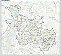
Topographic map of Overijssel, 2019
-
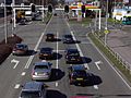
Rijksweg N35 Ceintuurbaan in Zwolle
-

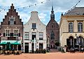
The Grote Markt in Zwolle, the provincial capital
-
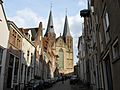
The Bergkerk from the Bergstraat, Deventer
-
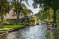
A canal in Giethoorn
-
Steenwijk
-
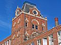
Water tower at the Jannink building in Enschede
-
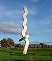
Beacon of Overijssel in Olst


See also
 In Spanish: Provincia de Overijssel para niños
