Salland facts for kids

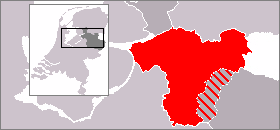
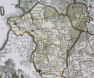
Salland is a historical area in the western and northern parts of the Dutch province of Overijssel. Today, when people talk about Salland, they usually mean the part of this old area that is west of Twente.
Contents
A Look Back: Salland's History

Salland, also known as Salalant, was first mentioned a very long time ago, in the early Middle Ages. It probably got its name from the IJssel river, which was once called Isala, and a lake area called Sallzee. This lake was where the Vecht and IJssel rivers met. Some people think Salland might have been where the Salian Franks originally lived.
Back then, Salalant was a small region called a shire (or gouw). It included the area around Zwolle, between places like Wijhe, Mastenbroek, and Dalfsen. In 795, a count named Wracharius ruled Salalant. His family kept control until the 11th century.
In 814, a place called Salahom was mentioned. It was located where the IJssel river flowed into the Sallzee. Later, in 1086, the four main parts of Oversticht (which were Salland, Twente, Vollenhove, and Drenthe) belonged to Egbert III. He was a descendant of Wracharius and a count himself. However, the Holy Roman Emperor Henry IV took these lands. He then gave them to the Prince-Bishopric of Utrecht, which was a powerful church state.
Salland slowly grew bigger. It stretched south to the Meppelerdiep and Reest rivers, and west to the Regge river. In 1246, the city of Deventer and its nearby areas, which used to be part of another county, became part of Salland.
In 1225, a special church official called an "episcopal sheriff" was put in charge of Salland. Later, in 1308, the bishop gave a "dike-right" to the land between the Hunnepe and the coast. This area later became known as the Salland sheriffdom.
In 1336, the bishop had to give almost all of Overijssel, including Salland, to the count of Guelders. But ten years later, the new bishop, Jan van Arkel, got the lands back. He also changed how the area was run. He divided Oversticht into three main areas: Twente, Vollenhove, and Salland. Even though these areas later became smaller "bailiwicks," they still form the basis for how Oversticht is divided today.
When the Archbishop of Utrecht sold his lands to Holy Roman Emperor Charles V in 1527, Salland became one of the three main parts of the new area called Overijssel. In 1581, Overijssel then became one of the seven provinces of the Dutch Republic.
Exploring Salland's Land
The exact borders of Salland are not always clear. But the largest area that can be called Salland, matching the historical region, has these boundaries:
- To the west: The border with the Gelderland province, partly formed by the IJssel river.
- To the north: The Meppelerdiep stream and the border with the Drente province, which includes the Reest stream.
- To the east: The borders with the German state of Lower Saxony and the eastern Overijssel region of Twente.
- To the south: The border with the Gelderland region of Achterhoek, partly formed by the Schipbeek stream.
So, Salland is basically all of Overijssel, except for Twente and the area known as "Kop van Overijssel."
Most of Salland's land is low and covered with rich river sediment (tiny bits of soil and rock carried by rivers). In the east, large moors (wet, spongy areas) have been drained to create pastures for animals. These moors, along with the hilly Holterberg region, used to be the natural border with Twente. On the Holterberg, you can still find parts of the original vast heathland (open land with small shrubs). In the northwest, people dug for peat (decayed plant matter used as fuel) in the boglands. This created low-lying areas that were easily flooded before 1932. That year, the Zuiderzee was closed off from the North Sea to become the IJsselmeer lake.
Salland is a low area with many rivers and streams. These waterways have left behind thick layers of rich river clay. The most important river is the IJssel. Other important waterways include the Zwarte Water and (Overijsselse) Vecht rivers. The Regge stream flows through Twente and then its last few kilometers are in Salland before it joins the Vecht near Ommen. There are also the Schipbeek stream and the Soestwetering stream, which combine with smaller streams near Zwolle to form the Zwarte Water river.
Three of Overijssel's biggest cities are in Salland: Deventer, Kampen, and the province's capital, Zwolle. Other important towns include Ommen and Hardenberg. These towns are often described as being in the "Vechtstreek" (Vecht Region) or "Vechtdal" (Vecht Valley), named after the river, rather than specifically in Salland.
Today, Salland often refers to the countryside between Deventer, Zwolle, Ommen, and Rijssen-Holten. Raalte is in the center of this area and has become its "unofficial capital." The Salland tourism board describes Salland as the land between the IJssel river and the hills, which means they use a much smaller definition of Salland than the historical one.
Changing Borders: Salland and Twente
In the early 2000s, there were some changes to how municipalities (local government areas) were organized within Overijssel. These changes made the border between Salland and Twente a bit less clear. Some municipalities that were historically part of Salland joined with Twente municipalities. For example, Holten is now part of the Rijssen-Holten municipality, and Den Ham is part of the Twenterand municipality. Also, because of its factories and businesses, and its location east of the Sallandse Heuvelrug hills, the municipality of Hellendoorn switched its association to Twente earlier in the 20th century.
Salland's Farthest Points
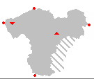
Here are the extreme (farthest) points of Salland:
- Northernmost Point — The very northern edge of the municipality of Staphorst.
- Southernmost Point — The very southern edge of the municipality of Deventer.
- Westernmost Point — Where the IJssel river flows into the sea, in the municipality of Kampen.
- Easternmost Point — The very eastern edge of Hardenberg municipality.
- Highest Point — The Archemerberg hill near Lemele in the municipality of Ommen. It is 77 meters (about 253 feet) above sea level.
- Lowest point — The Mastenbroek polder (a piece of low-lying land reclaimed from water) in the municipality of Kampen. It is 2 meters (about 6.5 feet) below sea level.
The changes to the municipal borders mentioned earlier do not affect where these extreme points of Salland are located.
Who Lives in Salland?
The total number of people living in Salland is thought to be around 500,000. This is about half of all the people who live in the province of Overijssel. The other half lives in Twente.
 | Charles R. Drew |
 | Benjamin Banneker |
 | Jane C. Wright |
 | Roger Arliner Young |


