Lost Lad facts for kids
Quick facts for kids Lost Lad |
|
|---|---|

Lost Lad
|
|
| Highest point | |
| Elevation | 518 m (1,699 ft) |
| Prominence | ca. 10 m |
| Parent peak | Back Tor (Derwent Edge) |
| Listing | none |
| Geography | |
| Location | Derbyshire, England |
| Parent range | Peak District |
| OS grid | SK193912 |
| Topo map | OS Landranger 110; OL1W |
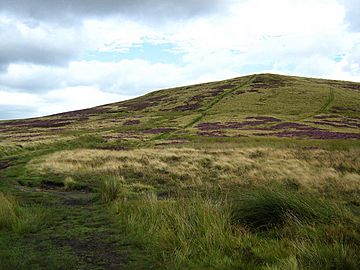
Lost Lad is a hill found in the beautiful Peak District in Derbyshire, England. It stands at 518 metres (1,699 ft) tall. This hill is part of the Derwent Edge and is a smaller peak of the nearby Back Tor, which is 538 metres [1,765 ft] high.
About Lost Lad
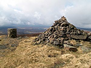
Lost Lad is a rounded hill with no trees, covered in moorland plants. It's a smaller peak that sits about 600 metres from Back Tor. At the very top of Lost Lad, you'll find a pile of stones called a cairn. There's also a toposcope there, which is a special marker that shows you the names of other hills and landmarks you can see from that spot. From the top, you get amazing views of the northern Peak District all around you!
The Story Behind the Name
The name "Lost Lad" actually refers to the cairn (the pile of stones) at the top of the hill. The name comes from an old legend about a shepherd boy. This boy was from the village of Derwent, which is now underwater because of a reservoir.
The story says that the shepherd boy got lost on the moors during a big snowstorm and sadly died. The next spring, another shepherd found his body. Near him, someone had written the words "Lost Lad" on a rock. This sad tale gave the cairn, and then the hill, its name.
 | Sharif Bey |
 | Hale Woodruff |
 | Richmond Barthé |
 | Purvis Young |


