
Derwent Edge facts for kids
Quick facts for kids Derwent Edge |
|
|---|---|
.jpg)
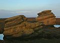
The Salt Cellar with Ladybower Reservoir in the Background
|
|
| Highest point | |
| Elevation | 538 m (1,765 ft) (Back Tor) |
| Prominence | 67 m (220 ft) |
| Listing | TuMP |
| Geography | |
| Location | Derbyshire, England |
| Parent range | Kinder Scout |
| OS grid | SK197909 |
| Topo map | OS Landranger 110 |
Derwent Edge is a long, rocky ridge made of a type of stone called Millstone Grit. It sits high above the beautiful Upper Derwent Valley in the Peak District National Park in Derbyshire, England. The highest point on the Edge is called Back Tor, which is 538 metres (1,765 feet) tall. You can find an Ordnance Survey marker there. North of Back Tor, the ridge continues into Howden Edge and crosses into South Yorkshire.
Contents
What is Derwent Edge?
Derwent Edge is part of a high, flat area of moorland on the eastern side of the valley. It overlooks the Ladybower Reservoir. The rocks here, called Millstone Grit, are the last parts of a huge layer of gritstone that once covered the whole Peak District. Most of this rock was scraped away by giant sheets of ice during the last ice age.
This area is famous for its unusual rock formations, called tors. It also offers amazing views of the Derwent Valley and the wild Dark Peak landscape. Because it's close to Sheffield, many people love to come here for walks. Its popularity has led to some paths wearing away. To fix this, parts of the path between The Salt Cellar and Lost Lad Hillend have been paved with stone slabs. This helps protect the natural environment.
Amazing Rock Formations
Derwent Edge has several strangely shaped gritstone tors. These unique shapes were created over many centuries by wind, rain, and frost. Local people have given these tors special names, and now these names are even on official Ordnance Survey maps.
Some of the most famous tors include:
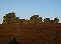
- The Cakes of Bread
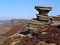
- The Coach and Horses
- The Salt Cellar
The Coach and Horses, also known as the Wheel Stones, looks like a horse-drawn coach when you see it from the A57 road to the south. Another spot worth visiting is Lost Lad Hillend. It has a stone marker that helps you identify different landmarks in the wide-open view.
Exploring Derwent Edge
Derwent Edge is a very popular place for walkers and hikers. Many guidebooks describe walks along the Edge. For example, a 10.5-mile walk starts from the Fairholmes car park in the Upper Derwent Valley. This car park is at the northern end of Ladybower Reservoir.
You can also reach the Edge from other places:
- Cutthroat Bridge (with parking) on the A57 road.
- Strines Reservoir car park, near the Strines public house.
The rock formations along Derwent Edge are also popular with rock climbers. Dovestone Tor is the largest and has about 50 different climbing routes. These routes range from easy to very difficult. However, it's not as busy as the nearby Stanage Edge, which is another famous climbing spot.
Protecting Nature
A lot of the moorland around Derwent Edge is a special protected area called a Site of Special Scientific Interest (SSSI). This is because it has unique plants and rare birds and animals.
Some of the special wildlife you might find here include:
- Eurasian golden plover (a type of bird)
- Red grouse (another bird)
- Ring ouzel (a bird similar to a blackbird)
- Mountain hare (a type of rabbit)
Rare plants also grow here, such as common cottongrass, mountain strawberry, and crowberry. This area has also been suggested as a Special Protection Area for birds under a European rule.
Derwent Edge is managed by the National Trust, a charity that looks after special places. Visitors are welcome to explore freely. However, it's important to stay on marked paths. This helps avoid disturbing the birds that nest here. Sometimes, parts of the moors might be closed for special management or for grouse shooting. Signs will be put up when this happens.
Images for kids
-
The Cakes of Bread, about 15 feet (4.6 metres) high
-
The Coach and Horse or Wheel Stones, about 25 feet (7.6 metres) high
-
Salt Cellar with the edge visible in the background
.JPG)
.JPG)

