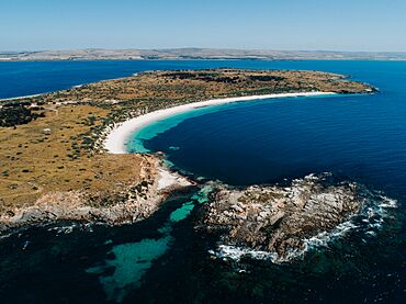
Louth Bay, South Australia facts for kids
Quick facts for kids Louth BaySouth Australia |
|||||||||||||||
|---|---|---|---|---|---|---|---|---|---|---|---|---|---|---|---|
 |
|||||||||||||||
| Established | 24 June 1909 (town) 16 October 2003 (locality) |
||||||||||||||
| Postcode(s) | 5607 | ||||||||||||||
| Time zone | ACST (UTC+9:30) | ||||||||||||||
| • Summer (DST) | ACST (UTC+10:30) | ||||||||||||||
| Location |
|
||||||||||||||
| LGA(s) | District Council of Lower Eyre Peninsula | ||||||||||||||
| Region | Eyre Western | ||||||||||||||
| County | Flinders | ||||||||||||||
| State electorate(s) | Flinders | ||||||||||||||
| Federal Division(s) | Grey | ||||||||||||||
|
|||||||||||||||
|
|||||||||||||||
| Footnotes | Location Adjoining localities |
||||||||||||||
Louth Bay is a town and a specific area (called a locality) in the Australian state of South Australia. It was named after the bay, which was explored by Matthew Flinders in 1802. Flinders named the bay after a place in England called Lincolnshire.
The town was first planned and created on 24 June 1909. It was initially called 'Laurence'. In 2006, about 408 people lived in Louth Bay.
Contents
History of Louth Bay
Naming the Town
The town was first surveyed, or mapped out, in March 1909. It was officially named 'Laurence' on 24 June 1909. This name honored Laurence O'Loughlin, who was a politician in South Australia.
However, people often called the area 'Louth Bay'. So, in November 1940, the local council decided to officially change the town's name to 'Louth Bay'. This change became official on 20 February 1941. The exact boundaries for the 'Louth Bay' locality were set in October 2003.
Islands Near Louth Bay
Louth Island is a large island located within Louth Bay. It is privately owned. About 3 kilometers southeast of Louth Island, you'll find the smaller Rabbit Island. Rabbit Island is part of the Lincoln National Park.
Early Activities and the Jetty
In the early 1900s, Louth Bay was a very popular spot for picnics. Even with visitors, the area stayed peaceful and wild.
Around the same time, people started dredging for oysters in the bay. This meant they would dig up oysters from the seabed.
A jetty, which is like a long pier for boats, was suggested for Louth Bay in 1878. It was built around that time. In 1908, the jetty was damaged, possibly by a ship. By 1949, the government wanted to remove the jetty. They asked companies to bid on the job. However, many local people objected and signed a petition, which delayed the decision to demolish it.
Modern Industries and Concerns
In the late 1900s, a new industry called aquaculture became important in Louth Bay. Aquaculture is like farming fish or other water creatures. However, some fishermen and local residents became worried about this. They were concerned about fish escaping from the farms and about pollution affecting the bay.
Some of their worries included:
- Too much algae growing in the water.
- Damage to the seagrass beds.
- plastic pollution from the farms.
- The area losing its natural beauty and peacefulness.
 | Toni Morrison |
 | Barack Obama |
 | Martin Luther King Jr. |
 | Ralph Bunche |


