Louvart River facts for kids
Quick facts for kids Louvart |
|
|---|---|

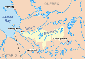
Watershed of Broadback River
|
|
| Country | Canada |
| Province | Quebec |
| Region | Nord-du-Québec |
| Physical characteristics | |
| Main source | Malsain Lake Eeyou Istchee Baie-James (municipalité), Nord-du-Québec, Jamésie, Quebec 214 m (702 ft) 50°51′16″N 77°57′03″W / 50.85444°N 77.95083°W |
| River mouth | Lepallier River Eeyou Istchee Baie-James (municipalité), Nord-du-Québec, Jamésie, Quebec 179 m (587 ft) 50°55′48″N 78°02′48″W / 50.93000°N 78.04667°W |
| Length | 14.4 km (8.9 mi) |
The Louvart River is a small river in Quebec, Canada. It flows into the Lepallier River. This river is located in the Nord-du-Québec region. It is part of the Eeyou Istchee Baie-James municipality.
The Louvart River flows southwest of the James Bay area. A winter road runs about 8.8 kilometers (5.5 miles) east of Louvart Lake. This road is used in winter and goes north-south. It runs alongside the main road from Matagami that goes further north.
The river usually freezes over from early November until mid-May. It's generally safe to travel on the ice from mid-November to mid-April.
River's Path and Surroundings
The Louvart River is surrounded by other rivers and lakes. These are part of its hydrographic slopes, which means the areas where water drains into the river.
- To the north, you'll find the Broadback River and the Lepallier River.
- To the east are Wemistikushiiuch Creek, Chaboullié Lake, Louvart Lake, Rodayer Lake, and the Pauschikushish Ewiwach River.
- To the south, there's the Nottaway River and Chechekw Creek, along with Dusaux Lake.
- To the west, you'll find more of the Nottaway River and the Kitchigama River.
Where the River Starts
The Louvart River starts at Louvart Lake. This lake is about 7.5 kilometers (4.7 miles) long. It sits 214 meters (702 feet) above sea level.
Louvart Lake is about 6.3 kilometers (3.9 miles) northeast of the Nottaway River. It's also about 14.6 kilometers (9.1 miles) west of Rodayer Lake. Rodayer Lake is 250 meters (820 feet) high and is where the Lepallier River begins. Louvart Lake is also about 63.1 kilometers (39.2 miles) west of Evans Lake.
How the River Flows
From Louvart Lake, the Louvart River flows generally northwest. It runs somewhat parallel to the Nottaway River, which is to its south. The Louvart River flows between the Nottaway River (south) and the Broadback River (north).
Finally, the Louvart River flows into the south bank of the Lepallier River. The Lepallier River then flows west into Rupert Bay. Rupert Bay is located south of James Bay.
Name of the River
The name Louvart River became official on December 5, 1968. This happened when the Commission de toponymie du Québec was created. This commission is in charge of naming places in Quebec.
 | Calvin Brent |
 | Walter T. Bailey |
 | Martha Cassell Thompson |
 | Alberta Jeannette Cassell |

