Louviers, Colorado facts for kids
Quick facts for kids
Louviers, Colorado
|
|
|---|---|

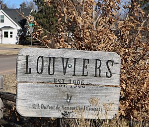
A sign marking the entrance to Louviers.
|
|

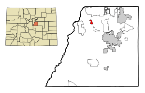
Location of the Louviers CDP in Douglas County, Colorado. Colorado
|
|
| Country | |
| State | |
| County | Douglas County |
| Founded | 1906 |
| Government | |
| • Type | unincorporated community |
| Area | |
| • Total | 1.580 sq mi (4.093 km2) |
| • Land | 1.580 sq mi (4.093 km2) |
| • Water | 0 sq mi (0.000 km2) |
| Elevation | 5,617 ft (1,712 m) |
| Population
(2020)
|
|
| • Total | 293 |
| • Density | 185.4/sq mi (71.59/km2) |
| Time zone | UTC-7 (MST) |
| • Summer (DST) | UTC-6 (MDT) |
| ZIP Code |
80131
|
| Area codes | 303 & 720 |
| GNIS feature | Louviers CDP |
Louviers is a small community in Douglas County, Colorado, United States. It's not a city or town with its own government. Instead, it's called an "unincorporated area" or a "census-designated place" (CDP). This means the government of Douglas County helps manage it. Louviers is also part of the larger Denver metropolitan area. In 2020, about 293 people lived in Louviers. It even has its own post office with the ZIP Code 80131.
Contents
The Story of Louviers
Louviers was created in 1906. The DuPont Company planned and built this community. They named it after a special place called Louviers, which was an estate belonging to the Du Pont family in Delaware. The Louviers Post Office has been open since 1907.
Where is Louviers Located?
Louviers is located in Colorado. Its eastern edge is next to U.S. Route 85. This road goes north about 20 miles (32 km) to the center of Denver. It also goes southeast about 12 miles (19 km) to Castle Rock. Castle Rock is the main town in Douglas County. The Louviers CDP covers an area of about 4.093 square kilometers (1.580 sq mi). All of this area is land.
How Many People Live in Louviers?
The United States Census Bureau first counted Louviers as a CDP for the United States Census 2000.
| Louviers CDP, Colorado | ||
|---|---|---|
| Year | Pop. | ±% |
| 2000 | 237 | — |
| 2010 | 269 | +13.5% |
| 2020 | 293 | +8.9% |
| Source: United States Census Bureau | ||
Schools in Louviers
Students in Louviers attend schools managed by the Douglas County School District.
See also
 In Spanish: Louviers (Colorado) para niños
 | Isaac Myers |
 | D. Hamilton Jackson |
 | A. Philip Randolph |


