Low Pass, Oregon facts for kids
Quick facts for kids
Low Pass, Oregon
|
|
|---|---|
 |
|
| Country | United States |
| State | Oregon |
| County | Lane |
| Time zone | UTC-8 (Pacific (PST)) |
| • Summer (DST) | UTC-7 (PDT) |
| ZIP code |
97419
|
| Area code(s) | 458 and 541 |
| GNIS feature ID | 1136499 |
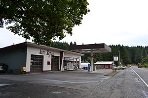
Low Pass is a small, quiet place in Lane County, Oregon, United States. It's known as an "unincorporated community." This means it's not a city or town with its own local government. Instead, it's a group of homes and businesses that are part of the larger county. Low Pass is located right by the Long Tom River. It's about 5 miles east of Blachly and 11 miles west of Cheshire.
What Makes Low Pass Special?
Low Pass is centered around a small stop along Oregon Route 36. Here, you'll find a gas station that also has a convenience store. There's also a diner that acts like a meeting spot for people living in the countryside nearby. It's a place where neighbors can gather and catch up.
Why Is It Called Low Pass?
The name "Low Pass" comes from its location. It sits on a gentle rise of land that leads up to the foothills of the Coast Range mountains. This "low pass" is different from another nearby mountain pass called High Pass. Much of the land to the west of Low Pass is covered in very old, tall trees. These are called old-growth forests. This land is managed by the Bureau of Land Management, which is a part of the U.S. government.
A Brief History of the Name
Before it was officially called Low Pass, this community was sometimes known as "Long Tom Station." This name came from the nearby Long Tom River. In 1985, the United States Board on Geographic Names made the name "Low Pass" official. This board is responsible for deciding and approving names for places in the United States.
 | George Robert Carruthers |
 | Patricia Bath |
 | Jan Ernst Matzeliger |
 | Alexander Miles |


