Lu'an facts for kids
Quick facts for kids
Lu'an
六安市
Liuan
|
|
|---|---|
|
Prefecture-level city
|
|
 |
|
| Country | People's Republic of China |
| Province | Anhui |
| County-level divisions | 7 |
| Township-level divisions | 196 |
| Municipal seat | Jin'an District |
| Area | |
| • Prefecture-level city | 15,436 km2 (5,960 sq mi) |
| • Urban | 4,127.5 km2 (1,593.6 sq mi) |
| • Metro | 3,561 km2 (1,375 sq mi) |
| Population
(2020 census)
|
|
| • Prefecture-level city | 4,393,699 |
| • Density | 284.640/km2 (737.214/sq mi) |
| • Urban | 1,968,766 |
| • Urban density | 476.988/km2 (1,235.392/sq mi) |
| • Metro | 1,752,537 |
| • Metro density | 492.15/km2 (1,274.66/sq mi) |
| GDP | |
| • Prefecture-level city | CN¥ 192.3 billion US$ 24.2 billion |
| • Per capita | CN¥ 43,666 US$ 6,769 |
| Time zone | UTC+8 (CST) |
| Area code(s) | 0564 |
| ISO 3166 code | CN-AH-15 |
| License Plate Prefix | 皖N |
| Administrative division code | 341500 |
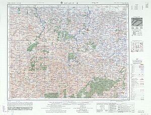
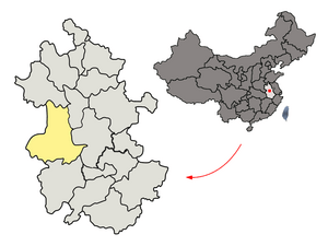
Lu'an (Chinese: 六安; pinyin: Lù'ān) is a large city in western Anhui province, China. It shares borders with Henan to the northwest and Hubei to the southwest. Lu'an is known as a "prefecture-level city." This means it's a major city that also manages several smaller areas around it, like districts and counties.
As of 2020, about 4.4 million people live in Lu'an. Over 1.7 million of them live in the main city area. This main area includes the Yu'an District and Jin'an District. Lu'an is close to other important cities. These include Hefei, which is the capital of Anhui province, and Anqing.
You might notice that the Chinese character for "six" (六) is usually pronounced "Liù." However, in the name Lu'an, it's pronounced "Lù." This is because of an old way of saying the word in Chinese history.
Contents
Geography and Climate of Lu'an
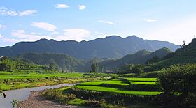
Lu'an is located in an interesting part of China. To the north, you'll find the southern edge of the North China Plain. This is a large, flat area. To the south, the city reaches into the northern parts of the Dabie Mountains. These are a range of hills and mountains.
The city's area stretches between 31°01′ and 32°40′ North latitude. It also spans from 115°20′ to 117°14′ East longitude.
Lu'an's Weather Patterns
Lu'an has a climate that is affected by monsoons. This means it gets a lot of rain during certain times of the year. It has a humid subtropical climate, which means it has four clear seasons.
- Winters are usually cold and wet. In January, the average low temperature is just below freezing.
- Summers are typically hot and humid. July is the warmest month, with an average temperature of about 28 degrees Celsius (82 degrees Fahrenheit).
- The average temperature for the whole year is about 16 degrees Celsius (61 degrees Fahrenheit).
- Lu'an gets a lot of rain, usually over 1,100 millimeters (43 inches) each year. Most of this rain falls between May and August.
- The city also gets a good amount of sunshine, usually between 2,000 and 2,300 hours per year.
| Climate data for Lu'an (1991–2020 normals, extremes 1971–2010) | |||||||||||||
|---|---|---|---|---|---|---|---|---|---|---|---|---|---|
| Month | Jan | Feb | Mar | Apr | May | Jun | Jul | Aug | Sep | Oct | Nov | Dec | Year |
| Record high °C (°F) | 22.5 (72.5) |
28.7 (83.7) |
34.9 (94.8) |
35.3 (95.5) |
37.6 (99.7) |
38.4 (101.1) |
40.6 (105.1) |
39.7 (103.5) |
40.0 (104.0) |
34.6 (94.3) |
31.2 (88.2) |
25.1 (77.2) |
40.6 (105.1) |
| Mean daily maximum °C (°F) | 7.2 (45.0) |
10.3 (50.5) |
15.6 (60.1) |
22.3 (72.1) |
27.0 (80.6) |
29.6 (85.3) |
32.6 (90.7) |
31.6 (88.9) |
27.7 (81.9) |
22.5 (72.5) |
16.3 (61.3) |
9.8 (49.6) |
21.0 (69.9) |
| Daily mean °C (°F) | 3.1 (37.6) |
5.8 (42.4) |
10.7 (51.3) |
17.0 (62.6) |
22.0 (71.6) |
25.3 (77.5) |
28.2 (82.8) |
27.3 (81.1) |
23.1 (73.6) |
17.6 (63.7) |
11.3 (52.3) |
5.3 (41.5) |
16.4 (61.5) |
| Mean daily minimum °C (°F) | 0.1 (32.2) |
2.5 (36.5) |
6.9 (44.4) |
12.6 (54.7) |
17.8 (64.0) |
21.8 (71.2) |
24.9 (76.8) |
24.2 (75.6) |
19.7 (67.5) |
13.8 (56.8) |
7.5 (45.5) |
2.1 (35.8) |
12.8 (55.1) |
| Record low °C (°F) | −13.6 (7.5) |
−11.6 (11.1) |
−3.2 (26.2) |
0.2 (32.4) |
7.6 (45.7) |
12.1 (53.8) |
18.0 (64.4) |
15.3 (59.5) |
10.7 (51.3) |
1.7 (35.1) |
−4.7 (23.5) |
−11.7 (10.9) |
−13.6 (7.5) |
| Average precipitation mm (inches) | 52.3 (2.06) |
53.0 (2.09) |
84.3 (3.32) |
88.7 (3.49) |
101.6 (4.00) |
156.4 (6.16) |
214.2 (8.43) |
150.7 (5.93) |
83.8 (3.30) |
60.1 (2.37) |
59.5 (2.34) |
35.0 (1.38) |
1,139.6 (44.87) |
| Average precipitation days (≥ 0.1 mm) | 9.1 | 9.3 | 11.5 | 10.4 | 11.4 | 11.1 | 12.9 | 12.6 | 9.9 | 9.1 | 9.1 | 7.5 | 123.9 |
| Average snowy days | 5.0 | 3.0 | 1.1 | 0 | 0 | 0 | 0 | 0 | 0 | 0 | 0.5 | 1.7 | 11.3 |
| Average relative humidity (%) | 73 | 72 | 70 | 68 | 70 | 77 | 79 | 81 | 77 | 73 | 72 | 70 | 74 |
| Mean monthly sunshine hours | 121.0 | 122.0 | 152.8 | 183.1 | 190.7 | 171.4 | 196.9 | 181.0 | 154.9 | 159.8 | 150.5 | 136.8 | 1,920.9 |
| Percent possible sunshine | 38 | 39 | 41 | 47 | 45 | 40 | 46 | 44 | 42 | 46 | 48 | 44 | 43 |
| Source 1: China Meteorological Administration | |||||||||||||
| Source 2: Weather China | |||||||||||||
How Lu'an is Managed
The city of Lu'an is divided into seven smaller areas. These areas help manage the city and its surrounding regions. There are three main city districts and four counties.
| Map | ||||||
|---|---|---|---|---|---|---|
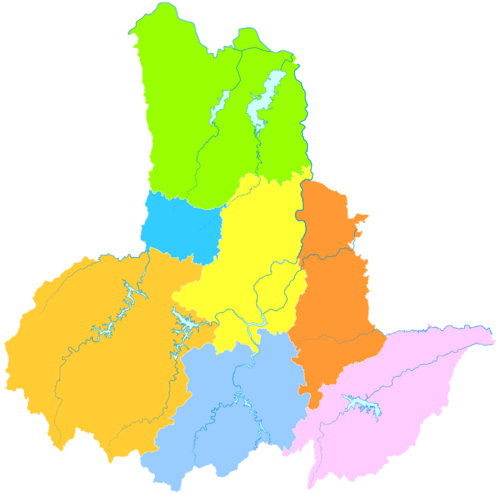
Jin'an
Yu'an
Yeji
Huoqiu
County Shucheng
County Jinzhai
County Huoshan
County |
||||||
| Name | Simplified Chinese | Hanyu Pinyin | Population (2015) |
Area (km²) | Density (/km²) | |
| Districts | ||||||
| Jin'an District | 金安区 | Jīn'ān Qū | 878,600 | 1653.58 | 531 | |
| Yu'an District | 裕安区 | Yù'ān Qū | 1,024,600 | 1925.61 | 532 | |
| Yeji District | 叶集区 | Yèjí Qū | 168,000 | 555.17 | 302 | |
| Counties | ||||||
| Huoqiu County | 霍邱县 | Huòqiū Xiàn | 1,702,200 | 3248.16 | 524 | |
| Shucheng County | 舒城县 | Shūchéng Xiàn | 995,000 | 2109.77 | 471 | |
| Jinzhai County | 金寨县 | Jīnzhài Xiàn | 674,400 | 3914.74 | 172 | |
| Huoshan County | 霍山县 | Huòshān Xiàn | 362,600 | 2040.42 | 177 | |
These seven areas are then divided even further. They are split into 142 smaller areas called "township-level divisions."
Transportation in Lu'an
Lu'an has important transportation routes that connect it to other parts of China.
- China National Highway 312 is a major road that passes through the city.
- Lu'an railway station is a train station that helps people travel to and from Lu'an by rail.
See also
 In Spanish: Lu'an para niños
 | William M. Jackson |
 | Juan E. Gilbert |
 | Neil deGrasse Tyson |


