Lucin Cutoff facts for kids
|
Southern Pacific Railroad:
Ogden-Lucin Cut-Off Trestle |
|
|
Formerly listed on the U.S. National Register of Historic Places
|
|

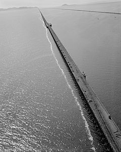
Aerial view of the Lucin Cutoff trestle
before removal. The 1950s causeway is to the right of the trestle. |
|
| Nearest city | Ogden, Utah |
|---|---|
| Area | 143 acres (58 ha) |
| Built | 1902–1904 |
| Architect | William Hood |
| NRHP reference No. | 72001257 |
Quick facts for kids Significant dates |
|
| Added to NRHP | April 14, 1972 |
| Removed from NRHP | October 23, 2018 |
The Lucin Cutoff is a 102-mile-long (164 km) railroad line in Utah, in the Western United States. It stretches from Ogden to a place called Lucin. The most famous part of this railroad was a nearly 12-mile-long (19 km) wooden trestle. This trestle crossed the Great Salt Lake.
The trestle was used from 1904 until the late 1950s. Then, a new path made of rock and dirt, called a causeway, replaced it. The Southern Pacific Railroad first built the cutoff. Their goal was to make the First Transcontinental Railroad shorter.
Today, the Union Pacific Railroad owns and runs the cutoff. It is a key part of their "Lakeside Subdivision." This subdivision runs from Ogden to Wells, Nevada. It is also a major part of the larger Overland Route. Because the Lucin Cutoff blocks water flow, the Great Salt Lake looks different colors from above. Water north of the cutoff often appears brown, while water to the south looks greener.
Contents
History of the Lucin Cutoff
Building the Original Line
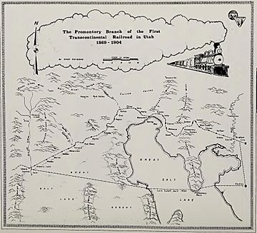
The Southern Pacific Company (SP) built the Lucin Cutoff between February 1902 and March 1904. This new route went around the older Central Pacific Railroad path. The original route went through Promontory Summit, where the famous Golden spike was driven in 1869.
By building west across the Great Salt Lake from Ogden to Lucin, the railroad saved 44 miles (71 km). It also made the tracks much straighter and flatter. William Hood, the chief engineer for SP, led the project. A team of 3,000 SP workers built the line. They worked every day of the week to get it done.
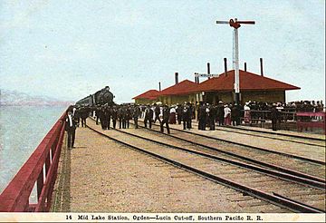
When the line first opened, it had short causeways on both sides of the lake. These causeways connected to a nearly 12-mile-long (19 km) wooden trestle. The cutoff also included a causeway that crossed Bear River Bay. This part had a 600-foot-long (180 m) trestle. This trestle allowed water from the Bear River to flow into the lake.
By 1908, many trains were using the Lucin Cutoff daily. Five passenger trains and seven freight trains traveled in each direction. In 1942, the original railroad line between Lucin and Corinne, Utah was removed. The last spikes from Promontory were pulled up. The metal was given to help with the war effort.
In late 1944, a serious train accident happened on the cutoff. A freight train crashed into a slower passenger train during thick fog.
Replacing the Trestle Bridge
The wooden trestle was mostly replaced in the late 1950s. A new causeway, made of dirt and rock, was built next to it. Morrison Knudsen of Boise, Idaho built this new causeway. The old trestle was still used a little bit alongside the causeway until about 1975.
Later, the railroad sold the rights to salvage the trestle. Cannon Structures, Inc., through its Trestlewood division, started taking it apart in the early 1990s. Trestlewood still sells the wood from the old trestle today.
Openings in the Causeway
The causeway blocked the lake water from flowing as freely as the open trestle had. To help with this, two large pipes, called culverts, were built into the original causeway. These culverts let boats pass through. They also allowed some water to flow from the southern part of the lake, where rivers empty, to the northern part.
In the early 1980s, Utah had very heavy flooding. A lot of extra water from the Wasatch Front flowed into the Great Salt Lake. This caused the lake to reach record high levels and flood nearby land. To help the culverts move more water to the northern part, the State of Utah built a 300-foot-long (91 m) bridge. This bridge was at the western end of the causeway.
On August 1, 1984, the state made a gap in the causeway under this new bridge. This allowed the water that had built up in the southern part to flow into the northern part. The causeway slowly sinks over time. Sometimes, more material is needed to raise its height above the lake. During the 1980s flooding, 1,430 old railcars were placed along the northern edge. They were filled with rock to act like baskets holding rocks, called gabions. This part is known as the "Boxcar Seawall."
In March 2011, the Union Pacific Railroad (UP) had to build another bridge and make a gap under it. Construction of a 180-foot-long (55 m) bridge finished in fall 2016. The railroad agreed to wait a few months before opening the gap. This was due to concerns about the environment and water levels. The causeway was finally opened beneath the 180-foot bridge on December 1, 2016. Since this opening, the water levels in the two parts of the lake have started to become more equal. By April 30, 2017, the water level in the northern part of the lake was within a foot of the southern part.
- Historic American Engineering Record (HAER) No. UT-13, "Southern Pacific Railroad, Ogden-Lucin Cutoff Trestle, Spanning Great Salt Lake, Brigham City, Box Elder County, UT", 42 photos, 2 color transparencies, 5 measured drawings, 12 data pages, 4 photo caption pages
 | Emma Amos |
 | Edward Mitchell Bannister |
 | Larry D. Alexander |
 | Ernie Barnes |


