
Lugton facts for kids
Quick facts for kids Lugton |
|
|---|---|
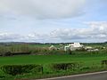
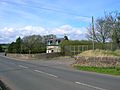
 The Lochlibo Road looking towards Glasgow from the site of the old Lugton Inn. |
|

Lugton
|
|
| Population | 80 (2001 Census) |
| OS grid reference | NS413529 |
| Council area | |
| Lieutenancy area |
|
| Country | Scotland |
| Sovereign state | United Kingdom |
| Police | Strathclyde |
| Fire | Strathclyde |
| Ambulance | Scottish |
| EU Parliament | Scotland |
| UK Parliament |
|
| Scottish Parliament |
|
Lugton is a small village in East Ayrshire, Scotland. About 80 people live there. The A736 road goes through Lugton. This road connects Glasgow, which is about 15 miles (24 km) north, to Irvine in North Ayrshire. The first village north of Lugton on this road is Uplawmoor, and to the south is Burnhouse. Lugton is located on the Lugton Water, a small river. This river forms the border between East Ayrshire and East Renfrewshire. It also marks the edge of the areas called Dunlop and Beith.
Contents
Exploring Lugton's Past
In the 1830s, Lugton was very tiny, with only four buildings. These included an inn (like a hotel), a blacksmith's shop, and two toll houses. By 1845, records show there were six other houses where drinks were sold. The road from Uplawmoor was known as the Lochlibo Road. Sadly, the old Lugton Inn burned down in the early 2000s.
The name 'Lugton' does not appear on old maps from the 1600s. However, some local farms like Waterlands and Biggart are shown. An old mill called Waterland Mill was also marked. Later maps from the 1800s started to show more details of the area. One inn, called the 'Paraffin Lamp Inn', was once a private house before it became a popular place for travelers.
What is a Turnpike Road?
Lugton was located on two 'turnpike' roads. These were special roads where people had to pay a toll to use them. One road went to Kilmarnock and Ayr, and the other went to Irvine. The road from Glasgow through Lugton to Kilmarnock, Irvine, and Ayr was finished in 1820. It cost a lot of money to build.
A tollhouse was a small building where people collected money from travelers. One tollhouse in Lugton stood opposite the old railway station. Another one is still standing behind where the Lugton Inn used to be. It was later used as a blacksmith's shop and is now a home.
The word 'turnpike' comes from the simple wooden bar used as a gate. This bar could 'turn' to let people pass. It looked like a 'pike', a weapon used by soldiers.
These turnpike roads were much better than older roads. They were smoother and often took a more direct route. Before turnpikes, different places used different lengths for a 'mile'. This caused a lot of confusion! The new roads helped make distances more standard. Tolls on roads were stopped in 1878.
Many old milestones (stones marking distances) were removed during the Second World War. This was done so that invading soldiers or spies couldn't use them to find their way. In some areas, like Fife, the stones were stored safely and put back after the war.
| What's in a Name? |
| The name Lugton likely comes from Ludgar or Lugdurr and Ton. A Toun or Ton was an old word for a farm and its buildings. Durr might be a Celtic word meaning 'black' or 'water'. |
Lugton's Economy and Work

Around 1850, iron ore was discovered near Lugton. A company built houses for 200 workers. Later, a brickworks was built nearby. It used the waste material from iron mining. This brickworks closed in 1921.
A lime works also existed near Lugton as early as 1829. Limestone is a mineral used by farmers to improve soil. It's also used in road building (tarmacadam) and was once used to make iron. Today, limestone is brought to Lugton from other places.
Local inns in the area had funny nicknames. The inn in Lugton was called the 'Lug 'Em Inn'. Other nearby inns had names like 'Trap 'Em Inn' and 'Cleek 'Em Inn'.
Many small limestone quarries and kilns (ovens for making lime) were marked on maps from the 1860s. There was also a corn mill on the Lugton Water, which was still in use in 1857 but later abandoned.
A creamery, which processed milk and made cheese, opened in 1919. It sent milk to Glasgow by train. It also made jams from vegetables during World War I. This creamery closed in 1919.
Getting Around Lugton
Lugton was once served by two railway stations, but both are now closed. Lugton railway station opened in 1871 and closed to passengers in 1966. The Lanarkshire and Ayrshire Railway also had a station called Lugton High station, which opened in 1903 and closed in 1932.
In 2000, a big emergency practice was held at Lugton. It was like a pretend train crash involving two passenger trains. The goal was to test how emergency services, like the police, ambulance, and fire brigade, would work together in a real accident. This exercise helped make train travel safer in Scotland.
Important Places in Lugton
Lugton Hall or Church
A small hall, which was used as both a church and a public meeting place, used to be near the railway bridge. It was moved there from an older site. The hall had two rooms, electricity, and even central heating in the 1930s. It was used for church services and meetings. This building was made of corrugated iron and was used until the 1960s. It was taken down in the 1990s, and a house now stands there. Lady Mure of Caldwell gave the Lugton Hall to the village.
Lugton School
In 1897, a small school stood close to the Lugton Water, behind the old blacksmith's shop.
Caldwell Mansion and Castle


The old Caldwell Castle was on a hill not far from Lugton. Only one tower of the castle remains today. A new, grand house called Caldwell House was built around 1712. The current house, designed by a famous architect named Robert Adam, was built later. Caldwell House was the home of the Mure family until 1909.
Old Discoveries in Lugton

Around 1770, six bronze bucklers (small, round shields) were found buried in a bog on Lugton ridge. They were found about 7 feet (2.1 m) deep and were arranged in a circle. One of these shields was saved. It was about 27 inches (686 mm) across and had a raised center part. It was beautifully decorated with many rings.
The Lugton Water River
This small river flows for about 14 miles (23 km). It starts at Loch Libo and flows through several areas like Neilston, Beith, and Dunlop. Eventually, it joins the River Garnock near Irvine. The Lugton Water has freshwater fish like trout and sometimes salmon.
Waterland Mill
In the 1600s, a corn mill called Waterland Mill was located on the Lugton Water. It was still in use in 1857, but by 1897, the mill and its buildings were no longer used.
Views in and Around Lugton
-
The Limeworks.
-
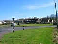
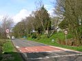
Looking across the Stewarton and Dunlop Road near the main road. 2007.
-
The old Tollhouse for the Glasgow to Irvine road. It was later part of a smithy.
-
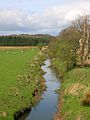
The Lugton Water looking towards Caldwell.
-
The old 1873 'Lugton' Stationmaster's house.
-
The old 1903 'Lugton High' Stationmaster's house.
-
The old 1903 'Lugton High' Stationmaster's house on the left and the much altered railway workers houses on the right.
-
The remains of the wooden pedestrian footbridge and way up to Lugton High station.


Lugton Stories and Local History
There's a local story that an underground passage once connected the old inn to Caldwell House. However, people who owned the house searched the cellars and never found any signs of a secret passage.
The village of Lugton is even mentioned in songs by a folk music group called Nyah Fearties, whose members are from the area.
Near Lugton is a quarry that is famous in geology textbooks. It has amazing marine fossils (old sea creatures) preserved in its rocks.
An old loch (lake) called Halket or Hawkhead Loch, which was about 10 acres (40,000 m2) in size, was drained in the 1840s. It appears on very old maps of Ayrshire.
