Mākaha, Hawaii facts for kids
Quick facts for kids
Makaha
Mākaha
|
|
|---|---|
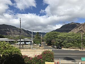
View of Mākaha Valley
|
|
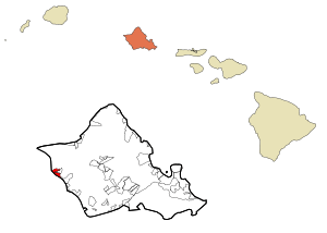
Location in Honolulu County and the state of Hawaii
|
|
| Country | United States |
| State | Hawaii |
| Area | |
| • Total | 5.55 sq mi (14.39 km2) |
| • Land | 2.69 sq mi (6.97 km2) |
| • Water | 2.87 sq mi (7.42 km2) |
| Elevation | 20 ft (6 m) |
| Population
(2020)
|
|
| • Total | 9,916 |
| • Density | 3,686.25/sq mi (1,423.25/km2) |
| Time zone | UTC-10 (Hawaii-Aleutian) |
| ZIP code |
96792
|
| Area code(s) | 808 |
| FIPS code | 15-47450 |
| GNIS feature ID | 0362017 |
Mākaha is a special town in Honolulu County, Hawaii, USA. Its name in Hawaiian means "fierce" or "savage" (pronounced [maːˈkɐhə]). It sits right on the Pacific coast, west of the Mākaha Valley. The town is also at the foot of Mt. Ka'ala in the Wai’anae Mountain Range. Mākaha is the last town on the leeward (drier) side of O'ahu as you go north. Beyond Mākaha, there are no more towns, gas stations, or restaurants.
In 2020, about 9,916 people lived in Mākaha. It is about 35 miles northwest of Honolulu, but it is still part of Honolulu County. The name "fierce" or "savage" comes from stories about groups of bandits who used to hide in the Mākaha Valley. They would wait for people passing by to rob them.
Mākaha has a higher number of Native Hawaiians and other Pacific islanders compared to most places on O’ahu. In 2010, about 26.2% of the people living there were Pacific Islanders. The Mākaha Resort often holds weekend events to celebrate traditional Hawaiian arts and crafts. These programs help keep the Native Hawaiian traditions alive in Mākaha.
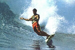
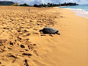
The town is famous for its amazing surfing waves and its history with surfing. It is also home to the Hawaiian temple Kāne’āki Heiau and Mākaha Beach Park. This beach is a safe place where several types of sea turtles come to lay their eggs. Besides surfing, people enjoy other water activities like diving, canoe-surfing, fishing, and bodysurfing.
Kāne’āki Heiau is one of Hawaii's most completely restored ancient temples. Experts from the Bishop Museum dug it up in 1970. You can visit it from Tuesday to Sunday. It started as a temple for farming, dedicated to the god Lono, in the 1400s. About 200 years later, it became a luakini, a special temple where sacrifices were made to the god Kū. This change showed that Mākaha had grown enough to have its own chief.
Contents
Exploring Mākaha's Location
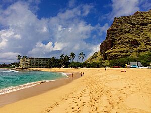
Mākaha is located at 21°28′14″N 158°12′51″W / 21.47056°N 158.21417°W. The total area of Mākaha is about 5.2 square miles (13.5 square kilometers). About 2.3 square miles (6.0 square kilometers) is land, and 2.9 square miles (7.5 square kilometers) is water.
Mākaha is the last town you will find when driving north on the leeward (drier) side of O'ahu. It is part of Honolulu County. The town is at the base of the Waianae Mountains, with the Pacific Ocean to its west. The Mākaha Valley is to its east. Mt. Ka'ala, the highest point on O'ahu at 4,020 feet (1,225 meters), is just east of Mākaha.
Getting to Mākaha
If you want to use public transportation, the express city bus C (Route C – Country Express) is the easiest way. It travels along the coast. Bus 40 goes up Mākaha Valley Road to the golf courses and then down Kili Drive to Mākaha Beach Park. Both buses leave daily from the Ala Moana Shopping Center in Downtown Honolulu.
If you are driving, you should follow Kamehameha Highway north of Pearl Harbor. Then, turn onto Farrington Highway (Route 93) to the west. Follow Farrington Highway north along Oahu's west shore. After you pass the nearby town of Waiʻanae, Mākaha is the next town. It is the last town on the leeward side of O’ahu. Mākaha Beach Park is in the center of town at 84-369 Farrington Hwy, Makaha HI 96792.
Surfing in Mākaha
Surfing has been a big part of Mākaha's history for a long time. It is believed that Native Hawaiians have surfed here for hundreds of years. In the early 1950s, Mākaha became known as a major surfing spot.
During the summer, the waves are usually about four feet high. But in the winter, the surf season brings much bigger waves, often over fifteen feet. Sometimes, the waves can even reach 25 feet! Because of these huge waves, the Waikīkī Surf Club started the Mākaha International Surfing Championships in 1952. This was the first of many international surfing contests held in Hawaii.
One of the most popular surfing events still held in Mākaha is Buffalo's Big Board Contest. This yearly contest is named after Richard “Buffalo” Keaulana, a Mākaha lifeguard and surfing legend. Buffalo created some amazing surfing styles in these waters. He also raised his son, Rusty, who became a world champion surfer. Buffalo made Mākaha the home of the world's first international surf meet in 1954. He still hosts his Big Board Surfing Classic today.
Another annual surfing event in Mākaha is Rell Sunn's Menehune Triple Lei of Surfing. Besides Mākaha Beach Park, other popular surfing spots in Mākaha include Aki's Beach, the Blowhole, Bowl, Charlie's Reef, and Cornets.
Mākaha's People
| Historical population | |||
|---|---|---|---|
| Census | Pop. | %± | |
| 2020 | 9,916 | — | |
| U.S. Decennial Census | |||
In the year 2000, there were 7,753 people living in Mākaha. These people lived in 2,388 households, and 1,721 of those were families. The population density was about 3,325 people per square mile (1,284 people per square kilometer).
The people in Mākaha came from many different backgrounds:
- 19.00% were White
- 1.39% were African American
- 0.71% were Native American
- 15.23% were Asian
- 21.90% were Pacific Islander
- 1.63% were from other races
- 40.14% were from two or more races.
About 17.86% of the population were Hispanic or Latino.
About 37.8% of households had children under 18 living with them. About 44.9% were married couples. About 19.6% had a female head of household with no husband present. The average household had 3.20 people, and the average family had 3.70 people.
The population was spread out by age:
- 31.7% were under 18 years old.
- 11.3% were from 18 to 24 years old.
- 26.1% were from 25 to 44 years old.
- 20.5% were from 45 to 64 years old.
- 10.3% were 65 years or older.
The average age was 30 years. For every 100 females, there were about 98.9 males.
The median income for a household was $35,674. For a family, it was $36,563. About 23.9% of the population lived below the poverty line. This included 32.8% of those under 18 and 9.3% of those 65 or older.
Schools in Mākaha
The Hawaii Department of Education is in charge of the public schools in Mākaha. Makaha Elementary School is located right in the town. Kamaile Elementary School is just outside the town.
Waianae High School has a Waianae mailing address. However, the school building is mostly located in Mākaha. A smaller part of the school is in Waianae.
See also
 In Spanish: Makaha para niños
 | Victor J. Glover |
 | Yvonne Cagle |
 | Jeanette Epps |
 | Bernard A. Harris Jr. |


