Madison, Missouri facts for kids
Quick facts for kids
Madison, Missouri
|
|
|---|---|

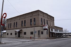
Intersection of US 24 and MO 151 in downtown Madison
|
|

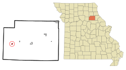
Location in Monroe County and the state of Missouri
|
|
| Country | United States |
| State | Missouri |
| County | Monroe |
| Area | |
| • Total | 0.45 sq mi (1.16 km2) |
| • Land | 0.45 sq mi (1.16 km2) |
| • Water | 0.00 sq mi (0.00 km2) |
| Elevation | 804 ft (245 m) |
| Population
(2020)
|
|
| • Total | 515 |
| • Density | 1,149.55/sq mi (444.16/km2) |
| Time zone | UTC-6 (Central (CST)) |
| • Summer (DST) | UTC-5 (CDT) |
| ZIP code |
65263
|
| Area code(s) | 660 |
| FIPS code | 29-45470 |
| GNIS feature ID | 2395808 |
Madison is a small city located in Monroe County, Missouri, in the United States. It's a friendly place with a population of about 515 people, according to the 2020 census.
Contents
History of Madison
The first people settled in Madison way back in 1836. A man named James R. Abernathy was one of the first settlers. He decided to name the town after James Madison, who was the fourth President of the United States.
In 1837, Abernathy planned out 40 acres of land in the town. He divided this land into 90 smaller pieces, called lots, and sold them. A post office was also opened in Madison in 1837, helping the community grow.
Geography and Location
Madison is in the western part of Monroe County. It's easy to find because U.S. Route 24 (also known as Broadway Street) goes right through it. This road leads east about 11 miles to Paris, which is the main town of the county. If you go west on the same road, you'll reach Moberly in about 14 miles.
Another important road, Missouri Route 151, also runs through the center of Madison. This route goes north about 21 miles to Clarence and south about 22 miles to Centralia.
The city of Madison covers a total area of about 0.45 square miles, and all of it is land. Water from the city flows into nearby creeks and rivers, eventually reaching the Salt River.
Population and People
| Historical population | |||
|---|---|---|---|
| Census | Pop. | %± | |
| 1880 | 315 | — | |
| 1890 | 486 | 54.3% | |
| 1900 | 538 | 10.7% | |
| 1910 | 688 | 27.9% | |
| 1920 | 646 | −6.1% | |
| 1930 | 664 | 2.8% | |
| 1940 | 625 | −5.9% | |
| 1950 | 571 | −8.6% | |
| 1960 | 528 | −7.5% | |
| 1970 | 540 | 2.3% | |
| 1980 | 656 | 21.5% | |
| 1990 | 518 | −21.0% | |
| 2000 | 586 | 13.1% | |
| 2010 | 554 | −5.5% | |
| 2020 | 515 | −7.0% | |
| U.S. Decennial Census | |||
The population of Madison changes over time. In 2010, there were 554 people living in the city. By 2020, the population was 515.
What the 2010 Census Showed
In 2010, there were 243 households in Madison. A household is a group of people living together. About 29.6% of these households had children under 18 living with them.
The average age of people in Madison in 2010 was 40 years old. About 24.2% of the residents were under 18, and 20% were 65 years or older. There were slightly more females (53.2%) than males (46.8%) living in the city.
Education in Madison
Public schools in Madison are managed by the Madison C-3 School District. This district runs an elementary school, a middle school, and Madison High School.
Madison also has a public library. It's part of the Little Dixie Regional Libraries system, which means residents can borrow books and use other resources.
See also
 In Spanish: Madison (Misuri) para niños

