Manasota Key, Florida facts for kids
Quick facts for kids
Manasota Key, Florida
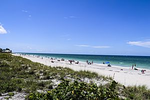
Englewood Beach
|
|
|---|---|

Englewood Beach
|
|

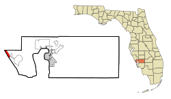
Location in Charlotte County and the state of Florida
|
|
| Country | United States |
| State | Florida |
| County | Charlotte |
| Area | |
| • Total | 3.07 sq mi (7.95 km2) |
| • Land | 1.06 sq mi (2.74 km2) |
| • Water | 2.01 sq mi (5.21 km2) |
| Elevation | 0 ft (0 m) |
| Population
(2020)
|
|
| • Total | 1,326 |
| • Density | 1,252.12/sq mi (483.57/km2) |
| Time zone | UTC-5 (Eastern (EST)) |
| • Summer (DST) | UTC-4 (EDT) |
| ZIP code |
34223
|
| Area code(s) | 941 |
| FIPS code | 12-42750 |
| GNIS feature ID | 1867173 |
Manasota Key is a beautiful coastal area in Charlotte County, Florida, United States. It is mostly known as the community of Englewood Beach. Manasota Key is called a census-designated place (CDP). This means it's an area defined by the government for collecting statistics, but it doesn't have its own local city government. In 2020, about 1,326 people lived here. Manasota Key is part of the larger Punta Gorda, Florida Metropolitan Statistical Area.
Contents
History of Manasota Key
Manasota Key is an island that is about 11 miles (18 kilometers) long. It used to be a peninsula, which is land almost surrounded by water. But it became an island when the Gulf Intracoastal Waterway was built. This waterway is a channel that allows boats to travel safely.
Where Does the Name "Manasota" Come From?
The name "Manasota" is a mix of two other names: "Sarasota" and "Manatee". These are the names of two counties nearby. The northern part of Manasota Key goes into Sarasota County. The part of the key in Charlotte County is where the community of Englewood Beach is located.
Geography of Manasota Key
Manasota Key is located in the northwest corner of Charlotte County. It's a narrow strip of land with water on both sides.
Water Bodies Around Manasota Key
To the west of Manasota Key is the vast Gulf of Mexico. This is where you'll find beautiful beaches and ocean waves. To the east is Lemon Bay, which is a calm, shallow body of water called an estuary. An estuary is where fresh water from rivers mixes with salt water from the ocean.
Connecting to the Mainland
The community of Englewood Beach is connected to the mainland by Beach Road. This road crosses over Lemon Bay, leading to the town of Englewood.
Stump Pass Beach State Park
The southern part of Manasota Key is home to Stump Pass Beach State Park. This park is a great place to explore nature. It includes Manasota Key itself, along with smaller islands like Peterson Island and Whidden Key.
Stump Pass is a natural channel that connects Lemon Bay to the Gulf of Mexico. It also separates Manasota Key from another island called Don Pedro Island to the south.
Land and Water Area
Manasota Key has a total area of about 3.1 square miles (8.0 square kilometers). About 1.1 square miles (2.7 square kilometers) of this is land, and the rest, about 2.0 square miles (5.2 square kilometers), is water.
Local Wildlife
An interesting animal, the extinct Chadwick Beach cotton mouse, used to live only in the Englewood Beach area.
Population and People
The number of people living in Manasota Key has changed a bit over the years.
- In 1990, there were 1,395 people.
- In 2000, the population was 1,345.
- By 2010, it was 1,229.
- In the most recent count in 2020, the population grew to 1,326 people.
Most of the people living in Manasota Key are White. A very small number are African American or Asian. About 1% of the population is Hispanic or Latino.
Many households in Manasota Key are made up of married couples. A large number of people living here are 65 years old or older. The average age of residents is 67 years.
See also
 In Spanish: Manasota Key para niños
 | Kyle Baker |
 | Joseph Yoakum |
 | Laura Wheeler Waring |
 | Henry Ossawa Tanner |

